The vector clipart library Geography contains 14 images of geographical features: ocean, forest, river, lake, waterfall, mountains, ravine, volcano, desert, hills, iceberg, trees.
Use the design elements library Geography to draw illustrations with landform images using the ConceptDraw PRO diagramming and vector drawing software.
"A landform in the earth sciences comprises a geomorphological unit, and is largely defined by its surface form and location in the landscape. As part of the terrain a landform is an element of topography. Landform elements also include land such as hills, mountains, plateaus,canyons,valleys, seascape and oceanic waterbody interface features such as bays, peninsulas, seas and so forth, including sub-aqueous terrain features such as mid-ocean ridges, volcanoes,and the great ocean basins." [Landform. Wikipedia]
This landscape illustration example is included in the Nature solution from the Illustration area of ConceptDraw Solution Park.
Vector illustration

The vector stencils library "Geography" contains 14 clipart images of natural landscapes and water features for drawing illustrations.
"A natural landscape is a landscape that is unaffected by human activity. A natural landscape is intact when all living and nonliving elements are free to move and change. The nonliving elements distinguish a natural landscape from a wilderness. A wilderness includes areas within which natural processes operate without human interference, but a wilderness must contain life. As implied, a natural landscape may contain either the living or nonliving or both." [Natural landscape. Wikipedia]
The clip art example "Geography - Vector stencils library" was created using the ConceptDraw PRO diagramming and vector drawing software extended with the Nature solution from the Illustration area of ConceptDraw Solution Park.
www.conceptdraw.com/ solution-park/ illustrations-nature
Ocean

Forest

River

Lake

Waterfall

Mountains

Mountain

Ravine

Volcano

Desert

Hills

Iceberg

Conifer tree

Tree

Geo Map - Europe - Greece

Geo Map - Asia - Kazakhstan

Landscape Plan

Electrical Symbols — VHF UHF SHF

"Snowboards are boards that are usually the width of one's foot longways, with the ability to glide on snow. Snowboards are differentiated from monoskis by the stance of the user. In monoskiing, the user stands with feet inline with direction of travel (facing tip of monoski/ downhill) (parallel to long axis of board), whereas in snowboarding, users stand with feet transverse (more or less) to the longitude of the board. Users of such equipment may be referred to as snowboarders. Commercial snowboards generally require extra equipment such as bindings and special boots which help secure both feet of a snowboarder, who generally rides in an upright position. These type of boards are commonly used by people at ski hills or resorts for leisure, entertainment and competitive purposes in the activity called snowboarding." [Snowboard. Wikipedia]
The vector icon example "Snowboard" represents one of 20 symbols from the Winter sports pictograms library for the ConceptDraw PRO diagramming and vector drawing software.
The design elements library Winter sports pictograms is included in the Winter Sports solution from the Sport area of ConceptDraw Solution Park.
Snowboard

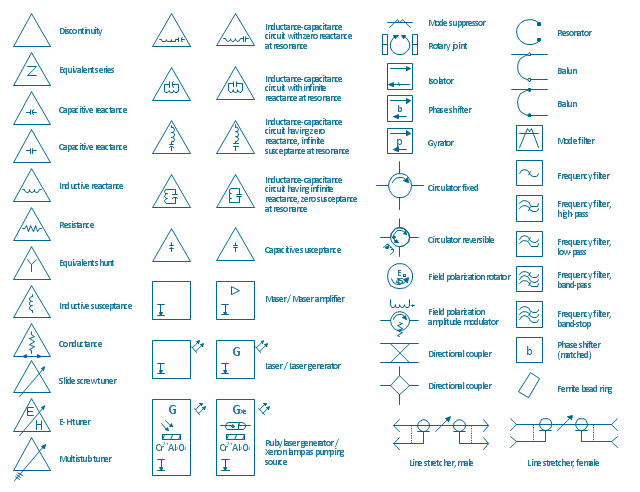
The vector stencils library "VHF UHF SHF" contains 52 symbols for VHF, UHF, and SHF circuit design, including capacitance measurers, nonreciprocal devices, modulators, phase shifters, field polarization devices, and filters.
"Very high frequency (VHF) is the ITU-designated range of radio frequency electromagnetic waves from 30 MHz to 300 MHz, with corresponding wavelengths of one to ten meters. Frequencies immediately below VHF are denoted high frequency (HF), and the next higher frequencies are known as ultra high frequency (UHF).
Common uses for VHF are FM radio broadcasting, television broadcasting, land mobile stations (emergency, business, private use and military), long range data communication up to several tens of kilometres with radio modems, amateur radio, and marine communications. Air traffic control communications and air navigation systems (e.g. VOR, DME & ILS) work at distances of 100 kilometres or more to aircraft at cruising altitude.
VHF was previously used for analog television stations in the US." [Very high frequency. Wikipedia]
"Ultra-high frequency (UHF) designates the ITU radio frequency range of electromagnetic waves between 300 MHz and 3 GHz (3,000 MHz), also known as the decimetre band or decimetre wave as the wavelengths range from one to ten decimetres; that is 1 decimetre to 1 metre. Radio waves with frequencies above the UHF band fall into the SHF (super-high frequency) or microwave frequency range. Lower frequency signals fall into the VHF (very high frequency) or lower bands. UHF radio waves propagate mainly by line of sight; they are blocked by hills and large buildings although the transmission through building walls is high enough for indoor reception. They are used for television broadcasting (digital and analogue), cordless phones, walkie-talkies, satellite communication, and numerous other applications.
The IEEE defines the UHF radar band as frequencies between 300 MHz and 1 GHz. Two other IEEE radar band overlap the ITU UHF band: the L band between 1 and 2 GHz and the S band between 2 and 4 GHz." [Ultra high frequency. Wikipedia]
"Super high frequency (or SHF) is the ITU designation for radio frequencies (RF) in the range of 3 GHz and 30 GHz. This band of frequencies is also known as the centimetre band or centimetre wave as the wavelengths range from ten to one centimetres. These frequencies fall within the microwave band, so radio waves with these frequencies are called microwaves. The small wavelength of microwaves allows them to be directed in narrow beams by aperture antennas such as parabolic dishes, so they are used for point-to-point communication and data links, and for radar. This frequency range is used for most radar transmitters, microwave ovens, wireless LANs, cell phones, satellite communication, microwave radio relay links, and numerous short range terrestrial data links. The commencing wireless USB technology will be using approximately 1/ 3 of this spectrum.
Frequencies in the SHF range are often referred to by their IEEE radar band designations: S, C, X, Ku, K, or Ka band, or by similar NATO or EU designations." [Super high frequency. Wikipedia]
The shapes example "Design elements - VHF UHF SHF" was drawn using the ConceptDraw PRO diagramming and vector drawing software extended with the Electrical Engineering solution from the Engineering area of ConceptDraw Solution Park.
VHF, UHF, SHF symbols
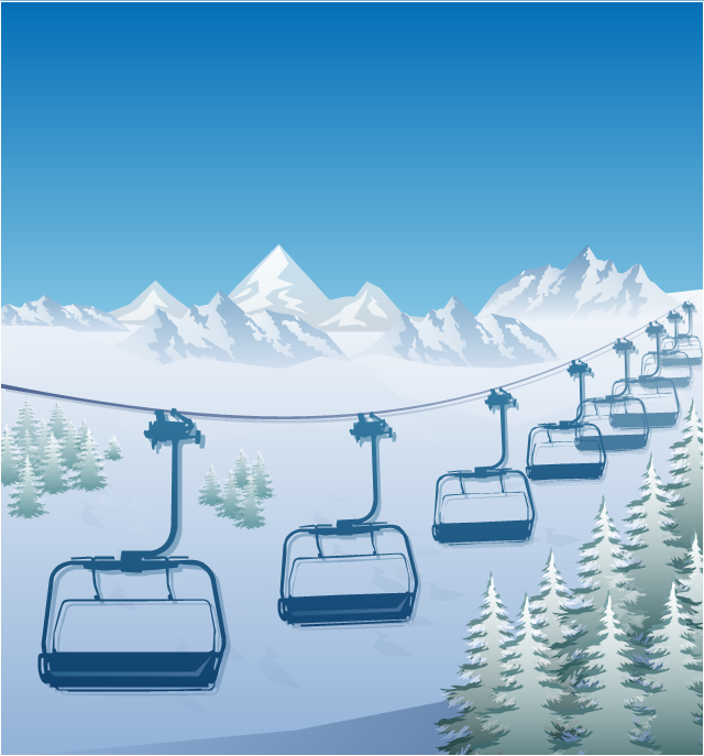
"The term ski lift generally refers to any cable transport device that carries skiers up a hill. A ski lift may fall into one of the following three main classes:
Aerial lifts, including:
Aerial tramways,
Chairlifts,
Detachable chairlifts,
Funifors,
Funitels,
Gondola lifts,
Telemix.
Surface lifts, including:
J-bars,
T-bars,
Magic carpets,
Platter / Button / Poma lifts,
Rope tows & handle tows.
Cable railways, including:
Funiculars." [Ski lift. Wikipedia]
The winter sport illustration example "Ski lift in the snow capped mountains" was created using the ConceptDraw PRO diagramming and vector drawing software extended with the Winter Sports solution from the Sport area of ConceptDraw Solution Park.
Winter sport illustration
- Drawing Of Mountains Rivers Forests Seas
- Draw Hill Mountain River Forest
- Drawing Of River Lake And Waterfall
- Green Landscape Hill Drawing Png
- Powerful Drawing Feature for Creating Professional Diagrams ...
- Hill Clipart Png
- How To Draw Hills River
- Map Software | How to Draw a Natural Landscape | Beautiful Nature ...
- Drawings Of Mountains And Sea
- Design elements - Geography | Geography - Vector stencils library ...
- Iceberg Draw
- Draw A Mountain Valley River Lake
- River Originated From Mountain Drawing
- Geography - Vector stencils library | How to Draw a Natural ...
- Natural Mountain Drawing
- Design elements - Geography | How to Draw a Natural Landscape ...
- How To Draw Sea River
- Design elements - Geography | Watercraft - Design Elements ...
- Nature | How to Draw a Natural Landscape | Map Software | Solution ...