The vector clipart library Geography contains 14 images of geographical features: ocean, forest, river, lake, waterfall, mountains, ravine, volcano, desert, hills, iceberg, trees.
Use the design elements library Geography to draw illustrations with landform images using the ConceptDraw PRO diagramming and vector drawing software.
"A landform in the earth sciences comprises a geomorphological unit, and is largely defined by its surface form and location in the landscape. As part of the terrain a landform is an element of topography. Landform elements also include land such as hills, mountains, plateaus,canyons,valleys, seascape and oceanic waterbody interface features such as bays, peninsulas, seas and so forth, including sub-aqueous terrain features such as mid-ocean ridges, volcanoes,and the great ocean basins." [Landform. Wikipedia]
This landscape illustration example is included in the Nature solution from the Illustration area of ConceptDraw Solution Park.
Vector illustration

Geo Map - Europe - Bulgaria

Use the Continent Maps solution to create Bulgaria geographical map, cartograms and thematic map, to help visualize the business and thematic information connected with geographic areas, locations or customs.
Geo Map - Europe - Russia

Geo Map - Europe

ConceptDraw PRO is idea to draw the geological maps of Europe from the pre-designed vector geo map shapes.
Use it to draw thematic maps, geospatial infographics and vector illustrations for your business documents, presentations and websites.
Geo Map - Europe - Greece

The vector stencils library Greece contains contours for ConceptDraw PRO diagramming and vector drawing software. This library is contained in the Continent Maps solution from Maps area of ConceptDraw Solution Park.
Geo Map - Asia - Kazakhstan

The vector stencils library Kazakhstan contains contours for ConceptDraw PRO diagramming and vector drawing software. This library is contained in the Continent Maps solution from Maps area of ConceptDraw Solution Park.
Geo Map - Europe - Iceland

The vector stencils library "Geography" contains 14 clipart images of natural landscapes and water features for drawing illustrations.
"A natural landscape is a landscape that is unaffected by human activity. A natural landscape is intact when all living and nonliving elements are free to move and change. The nonliving elements distinguish a natural landscape from a wilderness. A wilderness includes areas within which natural processes operate without human interference, but a wilderness must contain life. As implied, a natural landscape may contain either the living or nonliving or both." [Natural landscape. Wikipedia]
The clip art example "Geography - Vector stencils library" was created using the ConceptDraw PRO diagramming and vector drawing software extended with the Nature solution from the Illustration area of ConceptDraw Solution Park.
www.conceptdraw.com/ solution-park/ illustrations-nature
Ocean

Forest

River

Lake

Waterfall

Mountains

Mountain

Ravine

Volcano

Desert

Hills

Iceberg

Conifer tree

Tree

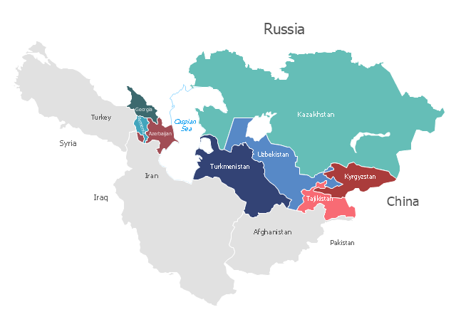
"Central Asia is the core region of the Asian continent and stretches from the Caspian Sea in the west to China in the east and from Afghanistan in the south to Russia in the north. It is also sometimes referred to as Middle Asia, and, colloquially, "the 'stans" (as the six countries generally considered to be within the region all have names ending with the Persian suffix "-stan", meaning "land of") and is within the scope of the wider Eurasian continent.
In modern contexts, all definitions of Central Asia include these five republics of the former Soviet Union: Kazakhstan (pop. 17.9 million), Kyrgyzstan (5.8 million), Tajikistan (8.0 million), Turkmenistan (5.2 million), and Uzbekistan (30.2 million), for a total population of 67.1 million as of 2013-2014. Afghanistan (pop. 31.1 million) is also sometimes included." [Central Asia. Wikipedia]
"The Caucasus / ˈkɔːkəsəs/ or Caucasia / kɔːˈkeɪʒə/ (for endonyms, see below), is a region at the border of Europe and Asia, situated between the Black and the Caspian seas. It is home to the Caucasus Mountains, which contain Europe's highest mountain, Mount Elbrus. Politically, the Caucasus region is separated between northern and southern parts. The southern parts consist of independent sovereign states: Abkhazia, Armenia, Azerbaijan, Georgia, Nagorno-Karabakh, South Ossetia, Turkey (part), Iran (part). The northern parts are under the jurisdiction of the Russian Federation." [Caucasus. Wikipedia]
This political map sample was redesigned from the Wikimedia Commons file: Caucasus central asia political map 2000.jpg. [commons.wikimedia.org/ wiki/ File:Caucasus_ central_ asia_ political_ map_ 2000.jpg]
The example "Caucasus and Central Asia 2000 - Political map" was created using the ConceptDraw PRO diagramming and vector drawing software extended with the Continent Maps solution from the Maps area of ConceptDraw Solution Park.
Political map - Caucasus and Central Asia 2000
Geo Map - Africa

Vector design elements library Africa contains country map contours, geographical maps, cartograms and thematic maps for ConceptDraw PRO diagramming and vector drawing software. To help visualize the business and thematic information connected with geographic areas, locations or customs.
All ConceptDraw PRO documents are vector graphic files and are available for reviewing, modifying, and converting to a variety of formats: image, HTML, PDF file, MS PowerPoint Presentation, Adobe Flash, MS Visio (.VDX, .VSDX).
Geo Map - South America - Honduras

The vector stencils library Honduras contains contours for ConceptDraw PRO diagramming and vector drawing software. This library is contained in the Continent Maps solution from Maps area of ConceptDraw Solution Park.
Use the map contours library "Asia" to design thematic maps of Asian countries using the ConceptDraw PRO diagramming and vector drawing software.
"Asia ... is the world's largest and most populous continent, located primarily in the eastern and northern hemispheres. ...
The boundaries of Asia are culturally determined, as there is no clear geographical separation between it and Europe, which together form one continuous landmass called Eurasia. The most commonly accepted boundaries place Asia to the east of the Suez Canal, the Ural River, and the Ural Mountains, and south of the Caucasus Mountains (or the Kuma–Manych Depression) and the Caspian and Black Seas. It is bounded on the east by the Pacific Ocean, on the south by the Indian Ocean and on the north by the Arctic Ocean." [Asia. Wikipedia]
The vector stencils library "Asia" contains 57 map contours: Asia state map contours, Asia political map, sea contours, lake contours.
The map contours example "Design elements - Asia" is included in the Continent Maps solution from the Maps area of ConceptDraw Solution Park.
Asia map contours

Geo Map - Africa - Tunisia

The vector stencils library Tunisia contains contours for ConceptDraw PRO diagramming and vector drawing software. This library is contained in the Continent Maps solution from Maps area of ConceptDraw Solution Park.
Geo Map - Asia - Syria

The vector stencils library Syria contains contours for ConceptDraw PRO diagramming and vector drawing software. This library is contained in the Continent Maps solution from Maps area of ConceptDraw Solution Park.
Geo Map - Asia

Use Geo Map Asia to draw thematic maps, geospatial infographics and vector illustrations for your business documents, presentations and websites.
- Drawing Of Mountains Rivers Forests Seas
- Mountain To River Illustration
- Design elements - Geography | How to Draw a Natural Landscape ...
- Draw Hill Mountain River Forest
- Design elements - Geography | Geography - Vector stencils library ...
- Features Of A Mountain Drawing
- Draw A Mountain Valley River Lake
- Geography - Vector stencils library | How to Draw a Natural ...
- Design elements - Geography | Watercraft - Design Elements ...
- Drawing Of River Lake And Waterfall
- Map Software | How to Draw a Natural Landscape | Beautiful Nature ...
- Aircraft - Design Elements | Design elements - Geography ...
- Ski lift in the snow capped mountains | Geography - Vector stencils ...
- Hills Drawing
- Mountain Illustration Vector Png
- Design elements - Geography | Landforms In Mountain Landscapes
- Free Clip Art River Flowing To The Sea
- Landscape Plan | Design elements - Geography | Geography ...
- Geography - Vector stencils library | Design elements - Geography ...
- Geo Map - Asia - Kazakhstan | Picture Of Mountain Rivers Seas On ...