 Nature
This solution extends ConceptDraw PRO software with samples, templates and libraries of vector clipart for drawing the Nature illustrations. Use it to make professional-looking documents, presentations and websites illustrated with color scalable vector c
How to Draw a Natural Landscape

The vector stencils library "Geography" contains 14 clipart images of natural landscapes and water features for drawing illustrations.
"A natural landscape is a landscape that is unaffected by human activity. A natural landscape is intact when all living and nonliving elements are free to move and change. The nonliving elements distinguish a natural landscape from a wilderness. A wilderness includes areas within which natural processes operate without human interference, but a wilderness must contain life. As implied, a natural landscape may contain either the living or nonliving or both." [Natural landscape. Wikipedia]
The clip art example "Geography - Vector stencils library" was created using the ConceptDraw PRO diagramming and vector drawing software extended with the Nature solution from the Illustration area of ConceptDraw Solution Park.
www.conceptdraw.com/ solution-park/ illustrations-nature
Ocean

Forest

River

Lake

Waterfall

Mountains

Mountain

Ravine

Volcano

Desert

Hills

Iceberg

Conifer tree

Tree

Map Software

The vector clipart library Geography contains 14 images of geographical features: ocean, forest, river, lake, waterfall, mountains, ravine, volcano, desert, hills, iceberg, trees.
Use the design elements library Geography to draw illustrations with landform images using the ConceptDraw PRO diagramming and vector drawing software.
"A landform in the earth sciences comprises a geomorphological unit, and is largely defined by its surface form and location in the landscape. As part of the terrain a landform is an element of topography. Landform elements also include land such as hills, mountains, plateaus,canyons,valleys, seascape and oceanic waterbody interface features such as bays, peninsulas, seas and so forth, including sub-aqueous terrain features such as mid-ocean ridges, volcanoes,and the great ocean basins." [Landform. Wikipedia]
This landscape illustration example is included in the Nature solution from the Illustration area of ConceptDraw Solution Park.
Vector illustration

How can you illustrate the weather condition

Beautiful Nature Scene: Drawing

Drawing Illustration

Geo Map - Africa

 Illustration
This solution extends ConceptDraw PRO v9.4, allowing you to make professional-looking documents, presentations and websites illustrated with color, scalable vector clip art and shapes, regardless of drawing skills.
Nature Drawings - How to Draw

Beauty in nature Illustrations and Clipart

Geo Map - Asia - Philippines

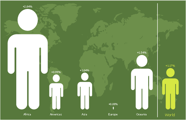
This picture bar graph sample shows regional population growth from 2010 to 2016. It was designed using data from the Wikipedia article List of continents by population.
[en.wikipedia.org/ wiki/ List_ of_ continents_ by_ population]
"Population geography is a division of human geography. It is the study of the ways in which spatial variations in the distribution, composition, migration, and growth of populations are related to the nature of places. Population geography involves demography in a geographical perspective. It focuses on the characteristics of population distributions that change in a spatial context." [Population geography. Wikipedia]
The pictorial chart example "Regional population growth from 2010 to 2016" was created using the ConceptDraw PRO diagramming and vector drawing software extended with the Picture Graphs solution from the Graphs and Charts area of ConceptDraw Solution Park.
Image chart
Map of Continents

- Solution Geography
- Geography - Vector stencils library | ConceptDraw Solution Park ...
- Design elements - Geography | Post and Mail - Design Elements ...
- How to Draw a Natural Landscape | Design elements - Geography ...
- Geography - Vector stencils library | Map Software | How to Draw a ...
- Design elements - Geography | How to Draw a Natural Landscape ...
- Geography - Vector stencils library | How to Draw a Natural ...
- Map Software | Nature | Maps | What Is A Flowchart In Geography
- Map Software | Geo Map - Africa | Drawing Illustration | Geography ...
- Geography Diagram
- How to Draw a Natural Landscape | Geography - Vector stencils ...
- Geography Diagram On Water Management Clipart
- Geography Software
- Solution Geography Diagram
- Design elements - Geography | How to Draw a Map of North ...
- Design elements - Geography | Geography - Vector stencils library ...
- Map Software | Design elements - Geography | Beauty in nature ...
- Geography - Vector stencils library | Design elements - Geography ...
- Design elements - Geography | Geo Map - Asia - Kazakhstan | Geo ...
- How To Draw A Easy Geography Picture