 Australia Map
For graphic artists creating accurate maps of Australia. The Australia Map solution - allows designers to map Australia for their needs, offers a collection of scalable graphics representing the political geography of Australia, split into distinct state
Australia Map

Map Australia

Map of Australia

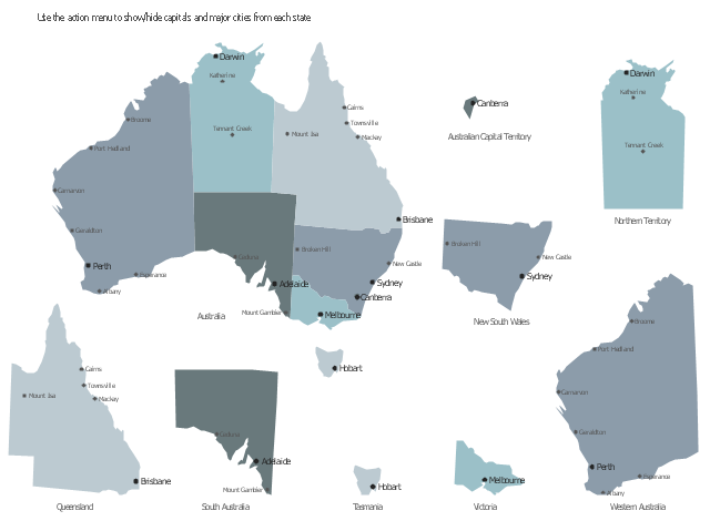
This sample displays map contours with capitals and main cities of Australia . Use it design your management infographics.
"The states and mainland territories of the Commonwealth of Australia combine to make up the world's sixth-largest country by total area. Australia comprises six states and various territories; the Australian mainland is made up of five states and three territories (including small, somewhat anomalous Jervis Bay Territory), with the sixth state being located on the island of Tasmania to the south of the mainland. In addition, there are six island territories, known as external territories. Australia also claims part of Antarctica as the Australian Antarctic Territory." [States and territories of Australia. Wikipedia]
The infogram shapes example "Design elements - Management map Australia" was created using the ConceptDraw PRO diagramming and vector drawing software extended with the Management Infographics solition from the area "Business Infographics" in ConceptDraw Solution Park.
Australia state map contours
Use the map contours library "Australia" to design thematic maps using the ConceptDraw PRO diagramming and vector drawing software.
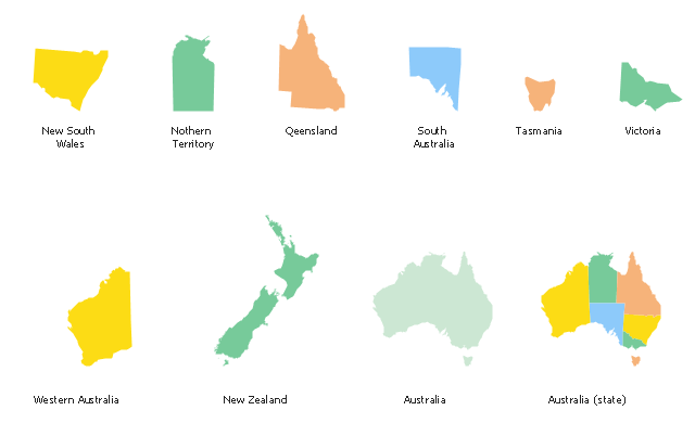
The vector stencils library "Australia" contains 10 map contours: Australia continent contour, Australia political maps, map contours of New Zealand and Australian states and mainland territories: New South Wales, Nothern Territory, Qeensland, Tasmania, Victoria, Western Australia.
The map contours example "Design elements - Australia" is included in the Continent Maps solution from the Maps area of ConceptDraw Solution Park.
Australia and New Zealand map contours
Geo Map - Australia - Victoria

Australia Map — States and Cities

Geo Map - Australia - New Zealand

Australia Map — Northern Territory

Geo Map - Australia

Australia Map — New South Wales

Australia Map — Queensland

Geo Map - Australia - South Australia

 Continent Maps
Continent Maps solution extends ConceptDraw PRO software with templates, samples and libraries of vector stencils for drawing the thematic maps of continents, state maps of USA and Australia.
- Australia states time zones - Thematic map | Design elements ...
- Geo Map - Europe | Design elements - Asia | Design elements ...
- Design elements - TCA cycle | Australia Map | Fire Exit Plan ...
- Map Australia
- Geo Map - Australia - Victoria
- Geo Map - Asia - Papua New Guinea | Geo Map - Australia | Design ...
- Australia map with cities - Template | Australia map - Template ...
- Continent Map Australia
- Map Australia | Geo Map - Asia - Israel | Competitor Analysis | Name ...
- Australia Map — South Australia
- Vector Map of Germany | Infographic design elements, software ...
- Australia Map | Geo Map - Australia - New Zealand | How to Draw ...
- Basic Flowchart Symbols and Meaning | Process Flowchart | Design ...
- Australia Map | Design elements - Asian country flags | All Famous ...
- Australia Map Example
- Design elements - Christmas and New Year | Geo Map - Australia ...
- Australia Map — South Australia | Victor Design Making Png
- Western Australia Map
- Australia map - Template | Geo Map - Australia - New Zealand ...
- How To use Landscape Design Software | Fault Tree Analysis ...