 Maps
Maps
This solution extends ConceptDraw DIAGRAM.4 with the specific tools necessary to help you draw continental, directional, road, or transit maps, to represent international, business, or professional information visually.
Continents Map

 Continent Maps
Continent Maps solution extends ConceptDraw DIAGRAM software with templates, samples and libraries of vector stencils for drawing the thematic maps of continents, state maps of USA and Australia.
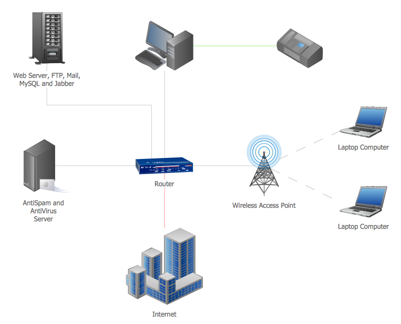
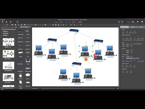
Area Network. Computer and Network Examples

The vector stencils library "Asia" contains 47 country contours for drawing thematic maps of Asia.
Use it in your spatial infographics for visual representation of geospatial information, statistics and quantitative data in the ConceptDraw PRO diagramming and vector drawing software extended with the Spatial Infographics solution from the area "What is Infographics" of ConceptDraw Solution Park.
Use it in your spatial infographics for visual representation of geospatial information, statistics and quantitative data in the ConceptDraw PRO diagramming and vector drawing software extended with the Spatial Infographics solution from the area "What is Infographics" of ConceptDraw Solution Park.
Asia

Afghanistan

Armenia

Azerbaijan

Bahrain

Bangladesh

Bhutan

Brunei

Burma (Myanmar)
-asia---vector-stencils-library.png--diagram-flowchart-example.png)
Cambodia

China

Cyprus

Georgia

India

Indonesia

Iran

Iraq

Israel

Japan

Jordan

Kuwait

Kazakhstan

Kyrgyzstan

Laos

Lebanon

Malaysia

Mongolia

Nepal

North Korea

Oman

Pakistan

Papua New Guinea

Philippines

Qatar

Saudi Arabia

Singapore

South Korea

Sri Lanka

Syria

Tajikistan

Thailand

Turkey

Turkmenistan

United Arab Emirates

Uzbekistan

Vietnam

Yemen

Geo Map - World

Chart Examples
Geo Map - Europe - United Kingdom

Tools to Create Your Own Infographics

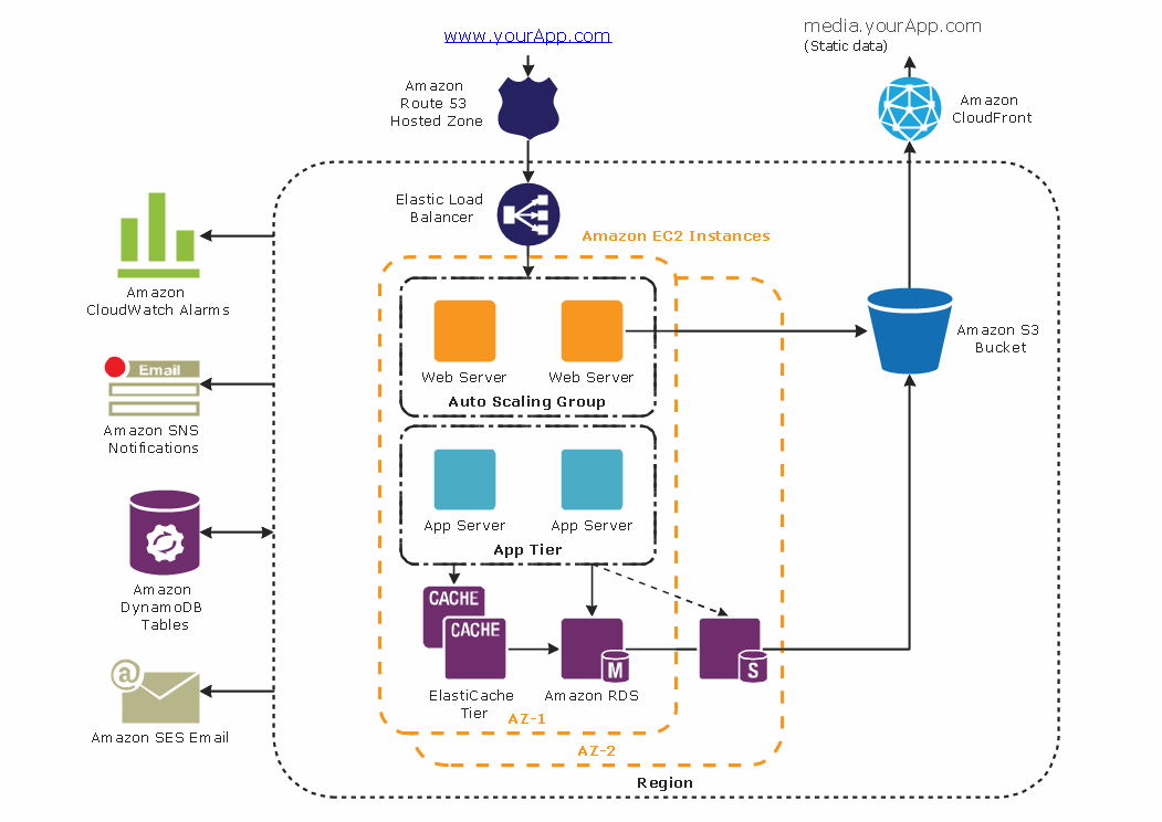
AWS
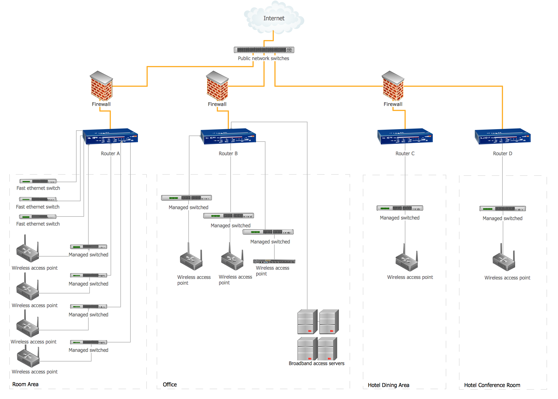
Hotel Network Topology Diagram
Geo Map — Europe — Poland

Geo Map Software

Geospatial Data
Pyramid Chart Examples
- Pakistan Map 3d Png
- Geo Map - Asia - Iran | 3D Column chart - Iran internet users per 100 ...
- Continent Maps | Middle East Map 3d
- Middle East - Political map | 3D Column chart - Iran internet users ...
- Flags - Stencils library | Ksa Map 3d
- Myanmar 3d Geological Map
- Geo Map - Asia - Philippines | Geo Map - Asia - Thailand | Geo Map ...
- Brunei Internet Map
- Geo Map - Asia - Laos | Draw A Map Of Latin America And Indicating ...
- Geo Map - Asia - Iran
- Geo Map - Asia | Continent Maps | UK Map | Middle East State ...
- Middle East - Political map | Geo Map - Asia | Continent Maps ...
- How to Draw Maps of Australia Using ConceptDraw PRO | Geo Map ...
- 3D pictorial street map | Directional Maps | Map Of A Neighborhood
- Continent Maps | Middle East - Political map | Geo Map - Asia ...
- Directional Maps | Design elements - 3D directional maps | 3D ...
- 3D pictorial street map | Star Network Topology | Road signs - Vector ...
- Geo Map - Asia - Pakistan
- Geo Map - South America Continent | Map Software | Geo Map ...
- Directional Maps | How to Create a Directional Map Using ...