This site uses cookies. By continuing to browse the ConceptDraw site you are agreeing to our Use of Site Cookies.
The vector stencils library "Asia" contains 57 Asian state map contours for drawing thematic and political maps of Asia. Use it for visual representation of geospatial information, statistics and quantitative data.
"Asia is the Earth's largest and most populous continent, located primarily in the eastern and northern hemispheres. ... Countries: 49 (and 5 disputed)." [Asia. Wikipedia]
The state map contours example "Asia - Vector stencils library" was created using the ConceptDraw PRO diagramming and vector drawing software extended with the Continent Maps solution from the Maps area of ConceptDraw Solution Park.
Asia
Asia, Singapore, Indonesia, Asia, Asia map,
Central Asia
Central Asia, Central Asia,
South Asia
South Asia, South Asia, Southern Asia, Southern Asia map,
East Asia
East Asia, East Asia,
Southeast Asia
Southeast Asia, Southeast Asia, Southeastern Asia map,
Afghanistan
Afghanistan, Afghanistan, Afghanistan map,
Armenia
Armenia, Armenia, Armenia map,
Azerbaijan
Azerbaijan, Azerbaijan, Azerbaijan map,
Bahrain
Bahrain, Bahrain, Bahrain map,
Bangladesh
Bangladesh, Bangladesh, Bangladesh map,
Bhutan
Bhutan, Bhutan, Bhutan map,
Brunei
Brunei, Brunei, Brunei map,
Burma (Myanmar)
Burma (Myanmar), Burma, Myanmar, Burma map, Myanmar map,
Cambodia
Cambodia, Cambodia, Cambodia map,
China
China, China, China map, People's Republic of China, PRC,
Cyprus
Cyprus, Cyprus, Cyprus map,
Georgia
Georgia, Georgia, Georgia map,
India
India, India, India map,
Indonesia
Indonesia, Indonesia, Indonesia map,
Iran
Iran, Iran, Iran map,
Iraq
Iraq, Iraq, Iraq map,
Israel
Israel, Israel, Israel map,
Japan
Japan, Japan, Japan map,
Jordan
Jordan, Jordan, Jordan map,
Kazakhstan
Kazakhstan, Kazakhstan, Kazakhstan map,
Kuwait
Kuwait, Kuwait, Kuwait map,
Kyrgyzstan
Kyrgyzstan, Kyrgyzstan, Kyrgyzstan map,
Laos
Laos, Laos, Laos map,
Lebanon
Lebanon, Lebanon, Lebanon map,
Malaysia
Malaysia, Malaysia, Malaysia map,
Maldives
Maldives, Maldives, Maldives map, Maldive Islands,
Mongolia
Mongolia, Mongolia, Mongolia map,
Nepal
Nepal, Nepal, Nepal map,
North Korea
North Korea, North Korea, North Korea map,
Oman
Oman, Oman, Oman map,
Pakistan
Pakistan, Pakistan, Pakistan map,
Papua New Guinea
Papua New Guinea, Papua New Guinea, Papua New Guinea map,
Philippines
Philippines, Philippines, Philippines map,
Qatar
Qatar, Qatar, Qatar map,
Russia (Asia)
Russia (Asia), Russia, Russian Federation, Asian part of Russia,
Saudi Arabia
Saudi Arabia, Saudi Arabia, Saudi Arabia map,
Singapore
Singapore, Singapore, Singapore map,
South Korea
South Korea, South Korea, South Korea map,
Sri Lanka
Sri Lanka, Sri Lanka, Sri Lanka map,
Syria
Syria, Syria, Syria map,
Taiwan
Taiwan, Taiwan, Republic of China, ROC,
Tajikistan
Tajikistan, Tajikistan, Tajikistan map,
Thailand
Thailand, Thailand, Thailand map,
Turkey
Turkey, Turkey, Turkey map,
Turkmenistan
Turkmenistan, Turkmenistan, Turkmenistan map,
United Arab Emirates
United Arab Emirates, United Arab Emirates, United Arab Emirates map,
Uzbekistan
Uzbekistan, Uzbekistan, Uzbekistan map,
Vietnam
Vietnam, Vietnam, Vietnam map,
Yemen
Yemen, Yemen, Yemen map,
Aral Sea
Aral Sea, Aral Sea,
Caspian Sea
Caspian Sea, Caspian Sea,
Lake Balkhash
Lake Balkhash, Lake Balkhash,
Used Solutions

World Continents Map

ConceptDraw PRO diagramming and vector drawing software enhanced with Continent Maps Solution from the Maps Area is the best for drawing geographic, topography, political, and many other kinds of maps for any of seven earth continents and also world continents map of any detailing.

Geo Map - Asia - United Arab Emirates

The United Arab Emirates, sometimes simply called the Emirates or the UAE, is a country located in the southeast end of the Arabian Peninsula on the Persian Gulf, bordering Oman to the east and Saudi Arabia to the south, as well as sharing sea borders with Qatar, Iran and Pakistan.
The vector stencils library United Arab Emirates contains contours for ConceptDraw PRO diagramming and vector drawing software. This library is contained in the Continent Maps solution from Maps area of ConceptDraw Solution Park.

Geo Map - South America - Guatemala

Guatemala, officially the Republic of Guatemala, is a country in Central America bordered by Mexico to the north and west, the Pacific Ocean to the southwest, Belize to the northeast, the Caribbean to the east, Honduras to the east and El Salvador to the southeast.
The vector stencils library Guatemala contains contours for ConceptDraw PRO diagramming and vector drawing software. This library is contained in the Continent Maps solution from Maps area of ConceptDraw Solution Park.

Aerospace - Design Elements

Samples, templates and libraries contain vector clip art for drawing the Aerospace Illustrations.

Geo Map - Asia - Sri Lanka

Sri Lanka, officially the Democratic Socialist Republic of Sri Lanka, is an island country in the northern Indian Ocean off the southern coast of the Indian subcontinent in South Asia; known until 1972 as Ceylon, Sri Lanka has maritime borders with India to the northwest and the Maldives to the southwest.
The vector stencils library Sri Lanka contains contours for ConceptDraw PRO diagramming and vector drawing software. This library is contained in the Continent Maps solution from Maps area of ConceptDraw Solution Park.

Map of Continents

A continent is one of several very large landmasses on Earth. ConceptDraw PRO diagramming and vector drawing software offers the unique Continent Maps Solution from the Maps Area which is indispensable for drawing the map of continents of the Earth.

Bar Diagrams for Problem Solving. Create space science bar charts with Bar Graphs Solution

Bar charts represent data in different categories or groups.
Create bar graphs for visual solving your scientific problems and data comparison using the ConceptDraw PRO diagramming and vector drawing software extended with the Bar Graphs Solution from the Graphs and Charts area of ConceptDraw Solition Park.
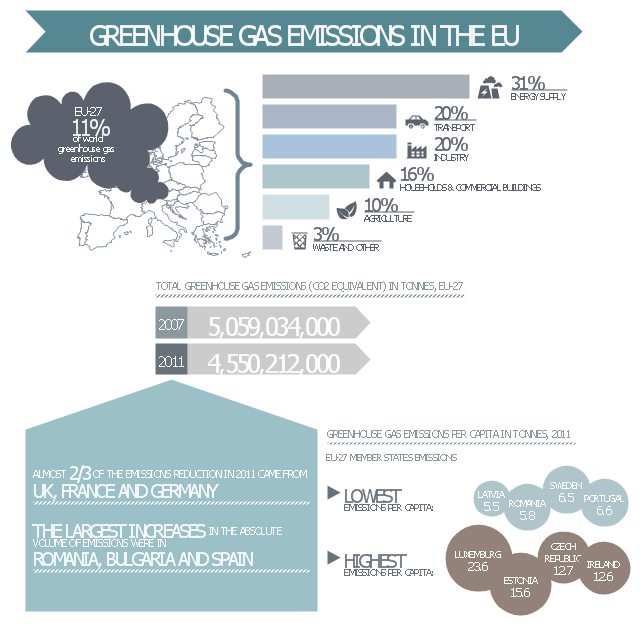
This ecology infographic example was created on the base of the infographics "Greenhouse gas emissions in the EU" from the Debating Europe website. [debatingeurope.eu/ wp-content/ uploads/ 2013/ 06/ TH_ 2_ social.png]
"A greenhouse gas (sometimes abbreviated GHG) is a gas in an atmosphere that absorbs and emits radiation within the thermal infrared range. This process is the fundamental cause of the greenhouse effect. The primary greenhouse gases in the Earth's atmosphere are water vapor, carbon dioxide, methane, nitrous oxide, and ozone. Greenhouse gases greatly affect the temperature of the Earth; without them, Earth's surface would average about 33 °C colder, which is about 59 °F below the present average of 14 °C (57 °F)." [Greenhouse gas. Wikipedia]
The ecology infographic example "EU greenhouse gas emissions" was created using the ConceptDraw PRO diagramming and vector drawing software extended with the Management Infographics solition from the area "Business Infographics" in ConceptDraw Solution Park.
Ecology infographics example
Ecology infographics example, trash bin, wastepaper basket, title text block, ribbon arrow callout, power plant, pointed up text block, nature, vegetation, horizontal bar chart, factory, industry, power plant, education diagram, cloud, circle callout, car, motor car, passenger car, callout with divider, bullet symbol, braces callout, curly brackets, squiggly brackets, arrow text block, United Kingdom, The Netherlands, Switzerland, Sweden, Spain, Slovenia, Slovakia, Serbia, Romania, Portugal, Poland, Montenegro, Malta, Macedonia, Luxembourg, Lithuania, Latvia, Kosovo, Italy, Ireland, Hungary, Greece, Germany, France, Finland, Estonia, Denmark, Czech Republic, Cyprus, Croatia, Bulgaria, Bosnia & Her., Belgium, Austria, Albania,

Geo Map - Asia - Malaysia

Malaysia is a federal constitutional monarchy in Southeast Asia.
The vector stencils library Malaysia contains contours for ConceptDraw PRO diagramming and vector drawing software. This library is contained in the Continent Maps solution from Maps area of ConceptDraw Solution Park.

Beauty in nature Illustrations and Clipart

Nature solution expands our software possibilities to create beautiful illustrations and cliparts with the new library which contains 17 vector objects.

Geo Map - Asia - Philippines

The Philippines, officially known as the Republic of the Philippines, is a sovereign island country in Southeast Asia situated in the western Pacific Ocean.
Use the Continent Maps solution and Philippines library to draw thematic maps, geospatial infographics and vector illustrations. This solution to help visualize the business and thematic information connected with geographic areas, locations or customs; for your business documents, presentations and websites.

USA Map

Usually designing of maps, including the USA Map is a quite complex, long and labour-intensive process. But now we have an excellent possibility to make it easier with ConceptDraw PRO diagramming and vector drawing software extended with powerful USA Maps Solution from the Maps Area of ConceptDraw Solution Park.

Geo Map - Africa - Algeria

Algeria, officially The People's Democratic Republic of Algeria, is a country in the Maghreb region of North Africa on the Mediterranean coast.
The vector stencils library Algeria contains contours for ConceptDraw PRO diagramming and vector drawing software. This library is contained in the Continent Maps solution from Maps area of ConceptDraw Solution Park.

Illustration Software

No science can't exist without illustrations, and especially astronomy! Illustrations help to visualize knowledge, natural phenomenons which are studied by astronomy, they equally effective help in work, during the learning process and on the conferences.
Now we have professional astronomy illustration software - ConceptDraw PRO illustration and sketching software with templates, samples and libraries of a variety of astronomy symbols, including constellations, galaxies, stars, and planet vector shapes; a whole host of celestial bodies. When drawing scientific and educational astronomy illustrations, astronomy pictures and diagrams, can help you reach for the stars!