"The Andean States are a group of nations in South America that are defined by sharing a common geography (Andes mountain range) or culture such as the Quechua language and Andean cuisine which was primarily spread during the times of the Inca Empire, but also before and after it.
Politically speaking, Argentina and Chile are usually not considered part of the Andean States as they lack a strong native Andean heritage and are culturally more oriented towards Europe and they are not a members of the Andean Community of Nations (which Venezuela is in the process of leaving).
The Andes occupy the western part of South America, stretching through the following countries: Colombia, Venezuela, Ecuador, Peru, Bolivia, Argentina (not considered to be -geopolitically- an Andean State), Chile (not considered to be -geopolitically- an Andean State)." [Andean states. Wikipedia]
"Southern Cone (Spanish: Cono Sur, Portuguese: Cone Sul) is a geographic region composed of the southernmost areas of South America, south of and around the Tropic of Capricorn. Traditionally, it covers Argentina, Chile and Uruguay, bounded on the west by the Pacific Ocean, and south to the junction between the Pacific and Atlantic Oceans, which is the closest continental area of Antarctica (1000 km). In terms of social and political geography, the Southern Cone comprises Argentina, Chile, Paraguay, Uruguay, Southern Brazil and the Brazilian state of São Paulo.
High life expectancy, the highest Human Development Index of Latin America, high standard of living, significant participation in the global markets and the emerging economy of its members make the Southern Cone the most prosperous macro-region in South America." [Southern Cone. Wikipedia]
Eastern South America (Brazil). "Brazil Listeni/ brəˈzɪl/ (Portuguese: Brasil, IPA: [bɾaˈziw]), officially the Federative Republic of Brazil (Portuguese: República Federativa do Brasil, About this sound listen (help·info)), is the largest country in both South America and the Latin American region. It is the world's fifth largest country, both by geographical area and by population. It is the largest Portuguese-speaking country in the world, and the only one in the Americas. Bounded by the Atlantic Ocean on the east, Brazil has a coastline of 7,491 km (4,655 mi). It is bordered on the north by Venezuela, Guyana, Suriname and the French overseas region of French Guiana; on the northwest by Colombia; on the west by Bolivia and Peru; on the southwest by Argentina and Paraguay and on the south by Uruguay. Numerous archipelagos form part of Brazilian territory, such as Fernando de Noronha, Rocas Atoll, Saint Peter and Paul Rocks, and Trindade and Martim Vaz. It borders all other South American countries except Ecuador and Chile and occupies 47 percent of the continent of South America." [Brazil. Wikipedia]
"The Guianas, sometimes called by the Spanish loan-word Guayanas (Las Guayanas) refers to a region in north-eastern South America which includes the following three territories:
(1) French Guiana, an overseas department of France,
(2) Guyana, known as British Guiana from 1831 until 1966, after the colonies of Berbice, Essequibo, and Demerara, taken from the Netherlands in 1814, were merged into a single colony,
(3) Suriname, until 1814 a part of Dutch Guiana, together with Berbice, Essequibo and Demerara." [The Guianas. Wikipedia]
This political map sample was redesigned from the Wikimedia Commons file: South America Color-coded Regions.png. [commons.wikimedia.org/ wiki/ File:South_ America_ Color-coded_ Regions.png]
This file is licensed under the Creative Commons Attribution-Share Alike 3.0 Unported license. [creativecommons.org/ licenses/ by-sa/ 3.0/ deed.en]
The example "South America regions - Political map" was created using the ConceptDraw PRO diagramming and vector drawing software extended with the Continent Maps solution from the Maps area of ConceptDraw Solution Park.
Political map - South America regions

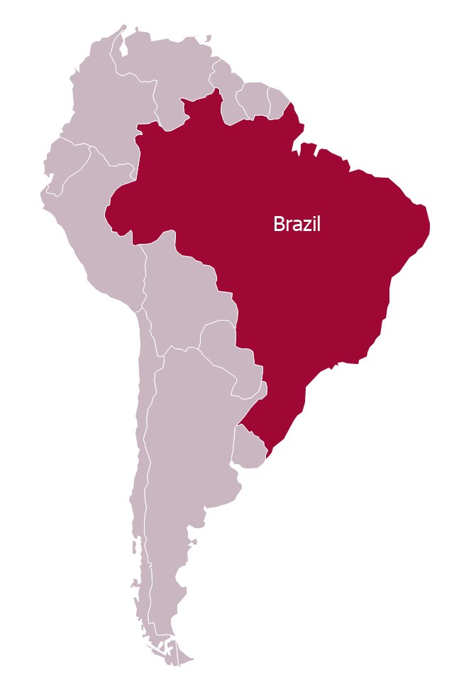
"Brazil ..., officially the Federative Republic of Brazil ... is the largest country in both South America and the Latin American region. It is the world's fifth largest country, both by geographical area and by population. It is the largest Lusophone country in the world, and the only one in the Americas.
Bounded by the Atlantic Ocean on the east, Brazil has a coastline of 7,491 km (4,655 mi). It is bordered on the north by Venezuela, Guyana, Suriname and the French overseas region of French Guiana; on the northwest by Colombia; on the west by Bolivia and Peru; on the southwest by Argentina and Paraguay and on the south by Uruguay. Numerous archipelagos form part of Brazilian territory, such as Fernando de Noronha, Rocas Atoll, Saint Peter and Paul Rocks, and Trindade and Martim Vaz. It borders all other South American countries except Ecuador and Chile and occupies 47 percent of the continent of South America." [Brazil. Wikipedia]
This Brazil in South America map was redesigned from Wikimedia Commons file: Brazil in South America (-mini map -rivers).svg. [commons.wikimedia.org/ wiki/ File:Brazil_ in_ South_ America_ (-mini_ map_ -rivers).svg]
This file is licensed under the Creative Commons Attribution-Share Alike 3.0 Unported license. [creativecommons.org/ licenses/ by-sa/ 3.0/ deed.en]
This Brazil in South America map example was drawn using ConceptDraw PRO diagramming and vector drawing software extended with design elements library South America. This example is included in the Continent Maps solution from the Maps area of ConceptDraw Solution Park.
Political map - Brazil in South America
Geo Map — South America Continent

Geo Map - South America - Brazil

Geo Map - South America - Mexico

Geo Map — South America — Peru

Geo Map - South America - Chile

Map of Continents

Geo Map - South America - Honduras

Geo Map — Europe — Poland

 Continent Maps
Continent Maps solution extends ConceptDraw PRO software with templates, samples and libraries of vector stencils for drawing the thematic maps of continents, state maps of USA and Australia.
Geo Map - Canada - British Columbia

Geo Map - USA - Mexico

"A thematic map is a type of map or chart especially designed to show a particular theme connected with a specific geographic area. ...
A thematic map is a map that focuses on a specific theme or subject area, whereas in a general map the variety of phenomena - geological, geographical, political - regularly appear together. ...
Thematic maps emphasize spatial variation of one or a small number of geographic distributions. These distributions may be physical phenomena such as climate or human characteristics such as population density and health issues. ...
Thematic map are sometimes referred to as graphic essays that portray spatial variations and interrelationships of geographical distributions. Location, of course, is important to provide a reference base of where selected phenomena are occurring. ...
Thematic maps serve three primary purposes.
First, they provide specific information about particular locations.
Second, they provide general information about spatial patterns.
Third, they can be used to compare patterns on two or more maps." [Thematic map. Wikipedia]
The vector stencils library "Thematic maps" contains 7 continent map contours for creating the thematic maps of geographic regions displaying the metric values by countries, states and territories marked by different colors.
Use the design elements library "Thematic maps" to create spatial dashboards using the ConceptDraw PRO diagramming and vector drawing software for your Spatial Intelligence and Location Intelligence business practice.
The example "Design elements - Thematic maps" is included in the Spatial Dashboard solution from the area "What is a Dashboard" of ConceptDraw Solution Park.
Thematic map templates

Geo Map - Europe - Portugal

- Southern Cone - Political map | South America regions - Political ...
- South America regions - Political map | Southern Cone - Political ...
- South America regions - Political map | Latin America - Vector ...
- South America regions - Political map | Andean states - Political map ...
- South America regions - Political map | East Africa - Political map ...
- South America regions - Political map | Geo Map - South America ...
- South America regions - Political map | Political map of Germany ...
- South America regions - Political map | Middle East - Political map ...
- South America regions - Political map | Map of South America - The ...
- South America regions - Political map | Canada regions - Political ...
- South America regions - Political map | South America - Political ...
- Middle East - Political map | Central Asia - Political map | South ...
- South America regions - Political map | Political map of Central ...
- World Continents Map | Continent Maps | South America regions ...
- South America regions - Political map | Geo Map - Asia - Papua New ...
- Continent Maps | South America regions - Political map | Benefit ...
- South America regions - Political map | World Continents Map ...
- Southern Cone - Political map | Rapid UML | South America regions ...
- Geo Map - South America - Guyana | South America regions ...