Geo Map — United States of America Map

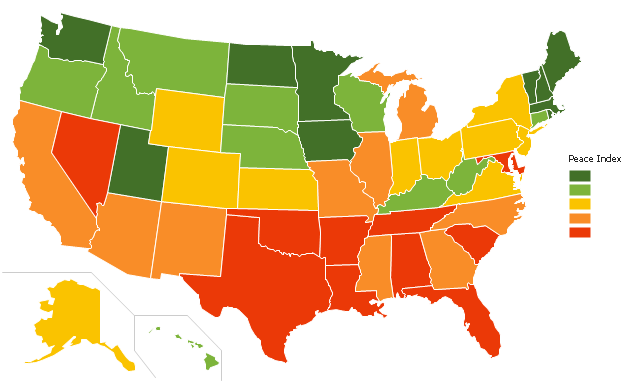
"The United States Peace Index (USPI) is a measurement of American States and cities by their peacefulness. Created by the Institute for Economics and Peace, the creators of the Global Peace Index, it is said to be the first in a series of National sub-divisions by their peacefulness." [United States Peace Index. Wikipedia]
This thematic map example was redesigned from the Wikimedia Commons file: 2011 USPI map.png.
[commons.wikimedia.org/ wiki/ File:2011_ USPI_ map.png]
This file is licensed under the Creative Commons Attribution 3.0 Unported license. [creativecommons.org/ licenses/ by/ 3.0/ deed.en]
The thematic map example "Ranks US states by peacefulness" was created using the ConceptDraw PRO diagramming and vector drawing software extended with the Continent Map solution from the Maps area of ConceptDraw Solution Park.
Thematic map - USA
Map of USA States

Geo Map of Americas

 USA Maps
Use the USA Maps solution to create a map of USA, a US interstate map, printable US maps, US maps with cities and US maps with capitals. Create a complete USA states map.
Map of USA

Geo Map — USA — Washington

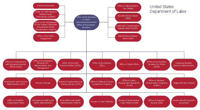
This organization chart sample was created on the base of the figure from the website of U.S. Department of Labor. [dol.gov/ dol/ aboutdol/ orgchart.htm]
"The United States Department of Labor (DOL) is a cabinet-level department of the U.S. federal government responsible for occupational safety, wage and hour standards, unemployment insurance benefits, re-employment services, and some economic statistics; many U.S. states also have such departments. The department is headed by the U.S. Secretary of Labor.
The purpose of the Department of Labor is to foster, promote, and develop the welfare of the wage earners, job seekers, and retirees of the United States; improve working conditions; advance opportunities for profitable employment; and assure work-related benefits and rights. In carrying out this mission, the Department of Labor administers and enforces more than 180 federal laws. These mandates and the regulations that implement them cover many workplace activities for about 10 million employers and 125 million workers." [United States Department of Labor. Wikipedia]
The organizational chart example "United States Department of Labor" was created using the ConceptDraw PRO diagramming and vector drawing software extended with the Organizational Charts solution from the Management area of ConceptDraw Solution Park.
Organizational chart
Geo Map — USA — Montana

Geo Map — USA — Mississippi

Geo Map - USA - Minnesota

Geo Map - USA - Ohio

Geo Map - USA - West Virginia

The vector stencils library "North America" contains 70 contours for drawing thematic maps of North America in spatial infographics.
Use it for visual representation of geospatial information, statistics and quantitative data in the ConceptDraw PRO diagramming and vector drawing software extended with the Spatial Infographics solution from the area "What is Infographics" of ConceptDraw Solution Park.
Use it for visual representation of geospatial information, statistics and quantitative data in the ConceptDraw PRO diagramming and vector drawing software extended with the Spatial Infographics solution from the area "What is Infographics" of ConceptDraw Solution Park.
North America

Greenland (Denmark)
-north-america---vector-stencils-library.png--diagram-flowchart-example.png)
Canada

Canada (provinces and territories)
-north-america---vector-stencils-library.png--diagram-flowchart-example.png)
Alberta

British Columbia

Manitoba

New Brunswick

Newfoundland and Labrador

Northwest Territories

Nova Scotia

Nunavut

Ontario

Prince Edward Island

Quebec

Saskatchewan

Yukon

USA

US states

Alabama

Alaska

Arizona

Arkansas

California

Colorado

Connecticut

Delaware

Florida

Georgia

Hawaii

Idaho

Illinois

Indiana

Iowa

Kansas

Kentucky

Louisiana

Maine

Maryland

Massachusetts

Michigan

Minnesota

Mississippi

Missouri

Montana

Nebraska

Nevada

New Hampshire

New Jersey

New Mexico

New York

North Carolina

North Dakota

Ohio

Oklahoma

Oregon

Pennsylvania

Rhode Island

South Carolina

South Dakota

Tennessee

Texas

Utah

Vermont

Virginia

Washington

West Virginia

Wisconsin

Wyoming

Mexico

Geo Map - USA - New York

- Ranks US states by peacefulness | Geo Map - United States of ...
- Geo Map - United States of America Map | Ranks US states by ...
- Map Of American States
- Geo Map - United States of America Map | Map 0f Us States
- Ranks US states by peacefulness
- Us States Map
- Map Of Us States
- Detailed Map Of Us States
- Map Showing Us States
- Geo Map - United States of America Map | Geo Map - USA - Iowa ...
- USA Map States
- Geo Map - United States of America Map | Map of USA | USA Maps ...
- USA Maps | Geo Map - USA - Kansas | Geo Map - United States of ...
- Benefit Corporation legislation - Thematic map | United States ...
- Geo Map - United States of America Map | Geo Map - USA ...
- USA Map | USA Maps | Map of USA States | Show Usa Map
- Geo Map - United States of America Map | Map of USA States | Map ...
- USA Maps | How to Draw a Map of USA States Using ConceptDraw ...
- How To Draw The United States With Their Full Names
- USA Maps | Map of USA | Map of USA States | Usa Map Template