A color-coded map showing US state-by-state status of Benefit Corporation legislation.
"A thematic map is a type of map or chart especially designed to show a particular theme connected with a specific geographic area. These maps "can portray physical, social, political, cultural, economic, sociological, agricultural, or any other aspects of a city, state, region, nation, or continent"." [Thematic map. Wikipedia]
This U.S.A. thematic map was redesigned from Wikipedia file: Benefit Corporation Map 2012 05 16.svg. [commons.wikimedia.org/ wiki/ File:Benefit_ Corporation_ Map_ 2012_ 05_ 16.svg]
This file is licensed under the Creative Commons Attribution-Share Alike 3.0 Unported license.
[creativecommons.org/ licenses/ by-sa/ 3.0/ deed.en]
This U.S. thematic map example was created using the ConceptDraw PRO diagramming and vector drawing software extended with the Continent Maps solution from the Maps area of ConceptDraw Solution Park.
Thematic map of U.S.

 USA Maps
Use the USA Maps solution to create a map of USA, a US interstate map, printable US maps, US maps with cities and US maps with capitals. Create a complete USA states map.
Geo Map — United States of America Map

Geo Map - USA - West Virginia

Map of USA

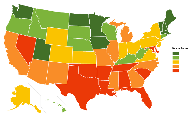
"The United States Peace Index (USPI) is a measurement of American States and cities by their peacefulness. Created by the Institute for Economics and Peace, the creators of the Global Peace Index, it is said to be the first in a series of National sub-divisions by their peacefulness." [United States Peace Index. Wikipedia]
This thematic map example was redesigned from the Wikimedia Commons file: 2011 USPI map.png.
[commons.wikimedia.org/ wiki/ File:2011_ USPI_ map.png]
This file is licensed under the Creative Commons Attribution 3.0 Unported license. [creativecommons.org/ licenses/ by/ 3.0/ deed.en]
The thematic map example "Ranks US states by peacefulness" was created using the ConceptDraw PRO diagramming and vector drawing software extended with the Continent Map solution from the Maps area of ConceptDraw Solution Park.
Thematic map - USA
Geo Map of Americas

HelpDesk
How to Draw Maps of Australia

Map of USA States

Geo Map — USA — Alaska

Geo Map - USA - Iowa

Geo Map — USA — Washington

Geo Map — USA — Wisconsin

Geo Map — USA — Mississippi

- Benefit Corporation legislation - Thematic map | Ranks US states by ...
- Geo Map - United States of America Map | Continent Maps ...
- Map of USA with state names | Benefit Corporation legislation ...
- Geo Map - United States of America Map | Geo Map - USA - Iowa ...
- Us Color Coded Map
- Geo Map - United States of America Map | Map of USA with state ...
- Geo Map - United States of America Map | Geo Map - USA ...
- Geo Map - United States of America Map | Geo Map - USA - Alaska ...
- Geo Map - United States of America Map | Andean states - Political ...
- Map Of States In America
- How to Draw a Map of USA States Using ConceptDraw PRO | Map ...
- Geo Map of Americas | Geo Map - United States of America Map ...
- Languages of South America - Thematic map | Europe thematic map ...
- North America Map With States And Capitals
- How to Draw a Map of North America Using ConceptDraw PRO ...
- Geo Map - United States of America Map | Map of USA States | How ...
- Design elements - Thematic maps | Visualization Spatial Data Using ...
- Geo Map - United States of America Map | USA Maps | Geo Map ...
- Ranks US states by peacefulness | Geo Map - United States of ...
- Continent Maps | Geo Map of Americas | Geo Map - United States of ...