The vector stencils library "Landmarks" contains 69 landmark symbols of buildings, waterways, scale and directional indicators for labeling transportation and directional maps, road and route maps, street and transit maps, locator and tourist maps.
The pictograms example "Landmarks - Vector stencils library" was created using the ConceptDraw PRO diagramming and vector drawing software extended with the Directional Maps solution from the Maps area of ConceptDraw Solution Park.
The pictograms example "Landmarks - Vector stencils library" was created using the ConceptDraw PRO diagramming and vector drawing software extended with the Directional Maps solution from the Maps area of ConceptDraw Solution Park.
Viewpoint

North arrow
North arrow
Building

Building

Town house

Suburban home

Skyscraper

Town hall

Public house

Petrol station

Gas station

Factory

School

Warehouse

Hospital

Fire station

Train station

Condos

Barn

Motel

Convenience store

Shopping centre

City

Church

Cathedral

National tail train station

Train railway

Bus stop

Tramlink

Marina / Ferry dock

Car ferry

Stop light

Airport

Airport

Underground / Subway / Metro

Taxi

Bicycle parking

Parking

Fuel / Gas / Petrol

Police

Hospital

Wheelchair access

First aid

Telephone

Post office

Landmarks and museums

University

Shopping

Refreshments / Public House

Restrooms / Toilets

Park

Zoo

Information center

Stadium 1

Stadium 2

Park

Tree

Fir-tree

Ocean

Lake

River

Angled river

Forked river

Curved river

Curved river

Flexible river

Bridge

Scale

"A locator map, sometimes referred to simply as a locator, is typically a simple map used in cartography to show the location of a particular geographic area within its larger and presumably more familiar context. Depending on the needs of the cartographer, this type of map can be used on its own or as an inset or addition to a larger map. ...
Direct marketing.
The widespread distribution of sophisticated Geographic Information System (GIS) mapping techniques has allowed the development of large-scale customized locator maps that can be tailored to individual consumers in direct marketing campaigns. This sophistication allows a variety of customized locator maps to be produced in a relatively short period of time. Major types of direct marketing locator maps are:
Single Location: A single business location is shown with major street and road connections. While this type of map can be efficiently constructed using GIS with existing street databases and customized map templates, special software is not required because the map does not change for each direct mailing." [Locator map. Wikipedia]
This example was created using the ConceptDraw PRO diagramming and vector drawing software extended with the Directional Maps solution from the Maps area of ConceptDraw Solution Park.
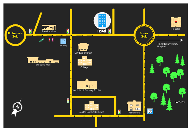
Hotel location map
The vector stencils library "Landmarks" contains 69 landmark symbols of buildings, waterways, scale and directional indicators for labeling transportation and directional maps, road and route maps, street and transit maps, locator and tourist maps.
The pictograms example "Landmarks - Vector stencils library" was created using the ConceptDraw PRO diagramming and vector drawing software extended with the Directional Maps solution from the Maps area of ConceptDraw Solution Park.
The pictograms example "Landmarks - Vector stencils library" was created using the ConceptDraw PRO diagramming and vector drawing software extended with the Directional Maps solution from the Maps area of ConceptDraw Solution Park.
Viewpoint
North arrow
North arrow
Building
Building
Town house
Suburban home
Skyscraper
Town hall
Public house
Petrol station
Gas station
Factory
School
Warehouse
Hospital
Fire station
Train station
Condos
Barn
Motel
Convenience store
Shopping centre
City
Church
Cathedral
National tail train station
Train railway
Bus stop
Tramlink
Marina / Ferry dock
Car ferry
Stop light
Airport
Airport
Underground / Subway / Metro
Taxi
Bicycle parking
Parking
Fuel / Gas / Petrol
Police
Hospital
Wheelchair access
First aid
Telephone
Post office
Landmarks and museums
University
Shopping
Refreshments / Public House
Restrooms / Toilets
Park
Zoo
Information center
Stadium 1
Stadium 2
Park
Tree
Fir-tree
Ocean
Lake
River
Angled river
Forked river
Curved river
Curved river
Flexible river
Bridge
Scale
"A locator map, sometimes referred to simply as a locator, is typically a simple map used in cartography to show the location of a particular geographic area within its larger and presumably more familiar context. Depending on the needs of the cartographer, this type of map can be used on its own or as an inset or addition to a larger map. ...
Direct marketing.
The widespread distribution of sophisticated Geographic Information System (GIS) mapping techniques has allowed the development of large-scale customized locator maps that can be tailored to individual consumers in direct marketing campaigns. This sophistication allows a variety of customized locator maps to be produced in a relatively short period of time. Major types of direct marketing locator maps are:
Single Location: A single business location is shown with major street and road connections. While this type of map can be efficiently constructed using GIS with existing street databases and customized map templates, special software is not required because the map does not change for each direct mailing." [Locator map. Wikipedia]
This example was created using the ConceptDraw PRO diagramming and vector drawing software extended with the Directional Maps solution from the Maps area of ConceptDraw Solution Park.
Direct marketing.
The widespread distribution of sophisticated Geographic Information System (GIS) mapping techniques has allowed the development of large-scale customized locator maps that can be tailored to individual consumers in direct marketing campaigns. This sophistication allows a variety of customized locator maps to be produced in a relatively short period of time. Major types of direct marketing locator maps are:
Single Location: A single business location is shown with major street and road connections. While this type of map can be efficiently constructed using GIS with existing street databases and customized map templates, special software is not required because the map does not change for each direct mailing." [Locator map. Wikipedia]
This example was created using the ConceptDraw PRO diagramming and vector drawing software extended with the Directional Maps solution from the Maps area of ConceptDraw Solution Park.
Hotel location map
The vector stencils library "Landmarks" contains 69 landmark symbols of buildings, waterways, scale and directional indicators for labeling transportation and directional maps, road and route maps, street and transit maps, locator and tourist maps.
The pictograms example "Landmarks - Vector stencils library" was created using the ConceptDraw PRO diagramming and vector drawing software extended with the Directional Maps solution from the Maps area of ConceptDraw Solution Park.
The pictograms example "Landmarks - Vector stencils library" was created using the ConceptDraw PRO diagramming and vector drawing software extended with the Directional Maps solution from the Maps area of ConceptDraw Solution Park.
Viewpoint
North arrow
North arrow
Building
Building
Town house
Suburban home
Skyscraper
Town hall
Public house
Petrol station
Gas station
Factory
School
Warehouse
Hospital
Fire station
Train station
Condos
Barn
Motel
Convenience store
Shopping centre
City
Church
Cathedral
National tail train station
Train railway
Bus stop
Tramlink
Marina / Ferry dock
Car ferry
Stop light
Airport
Airport
Underground / Subway / Metro
Taxi
Bicycle parking
Parking
Fuel / Gas / Petrol
Police
Hospital
Wheelchair access
First aid
Telephone
Post office
Landmarks and museums
University
Shopping
Refreshments / Public House
Restrooms / Toilets
Park
Zoo
Information center
Stadium 1
Stadium 2
Park
Tree
Fir-tree
Ocean
Lake
River
Angled river
Forked river
Curved river
Curved river
Flexible river
Bridge
Scale
The vector stencils library "Road signs" contains 58 symbols of road signs for labeling the road and route maps, directional and transit maps, street and locator maps.
"Traffic signs or road signs are signs erected at the side of or above roads to give instructions or provide information to road users.
... many countries have adopted pictorial signs or otherwise simplified and standardized their signs to overcome language barriers, and enhance traffic safety. Such pictorial signs use symbols (often silhouettes) in place of words and are usually based on international protocols. Such signs were first developed in Europe, and have been adopted by most countries to varying degrees." [Traffic sign. Wikipedia]
The pictograms example "Road signs - Vector stencils library" was created using the ConceptDraw PRO diagramming and vector drawing software extended with the Directional Maps solution from the Maps area of ConceptDraw Solution Park.
www.conceptdraw.com/ solution-park/ maps-directional
Danger place

Intersection

Intersection 2

Bend

Double bend

Two-way traffic

Mobile bridge

Light signal

Pedestrian crossing

Road work

Back-up

Give way

Crossing

Stop

Roundabout

Pass this side

Direction to be followed

One-way street

Cycle track

No entry

No entry both directions

No power vehicles

No U-turns

No passing without stopping

No standing and parking

No parking

Speed limit

Height limit

Width limit

Weight limit

Priority over oncoming traffic

Streetcar or regular buses

Taxi status

Beginning that speed 30-Zone

End that speed 30-Zone

Pedestrian crossing 2

Police

Hotel

Breakdown service

Restaurant

P + R

Restroom

Fuel

Telephone

Recommended speed

Nodal point of a motorwa

Parking

Dead end

Motorway

End motorway

Populated zone

End populated zone

Parking with clock

Number sign (motorway)
-road-signs---vector-stencils-library.png--diagram-flowchart-example.png)
Exit

Direction to place

Board of announcement of exit

Number sign (federal highway)
-road-signs---vector-stencils-library.png--diagram-flowchart-example.png)
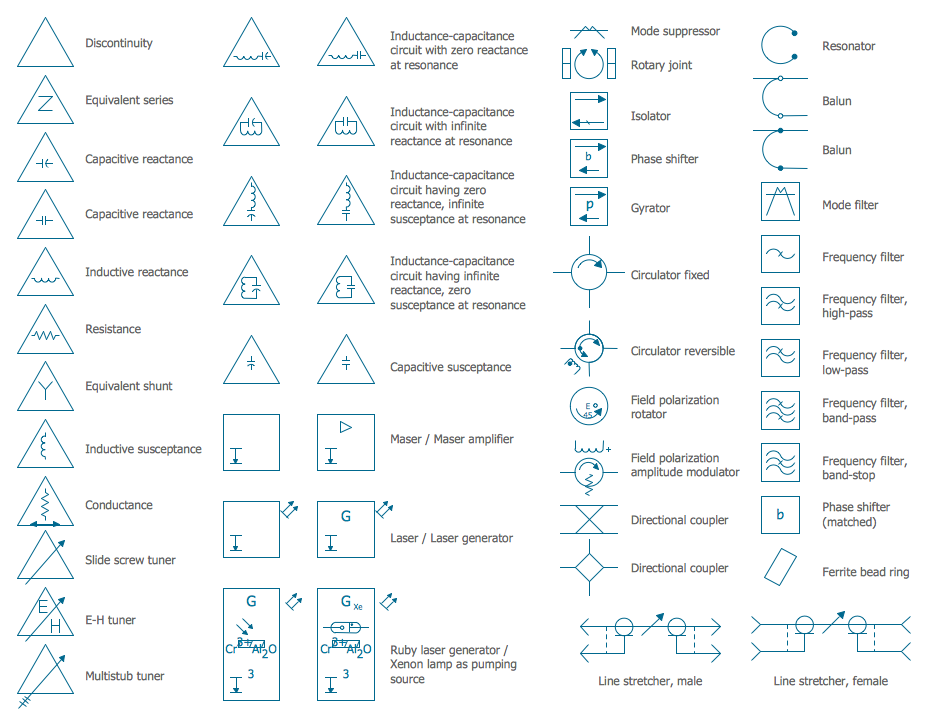
Electrical Symbols — VHF UHF SHF
Network Glossary Definition

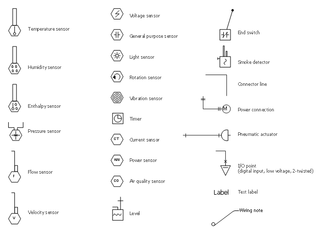
The vector stencil library "HVAC controls" contains contains 24 HVAC control symbols: sensors, actuators, timers, controllers, I/ O points.
Use it for drawing HVAC system diagrams, heating, ventilation, air conditioning, refrigeration, automated building control, and environmental control design floor
plans and equipment layouts.
"HVAC (... Heating, Ventilation and Air Conditioning) is a control system that applies regulation to a heating and/ or air conditioning system. ...
Central controllers and most terminal unit controllers are programmable, meaning the direct digital control program code may be customized for the intended use. The program features include time schedules, setpoints, controllers, logic, timers, trend logs, and alarms. The unit controllers typically have analog and digital inputs that allow measurement of the variable (temperature, humidity, or pressure) and analog and digital outputs for control of the transport medium (hot/ cold water and/ or steam). Digital inputs are typically (dry) contacts from a control device, and analog inputs are typically a voltage or current measurement from a variable (temperature, humidity, velocity, or pressure) sensing device. Digital outputs are typically relay contacts used to start and stop equipment, and analog outputs are typically voltage or current signals to control the movement of the medium (air/ water/ steam) control devices such as valves, dampers, and motors." [HVAC control system. Wikipedia]
The vector stencils example "Design elements - HVAC controls" is included in HVAC Plans solution from the Building Plans area of ConceptDraw Solution
Park.
HVAC control symbols
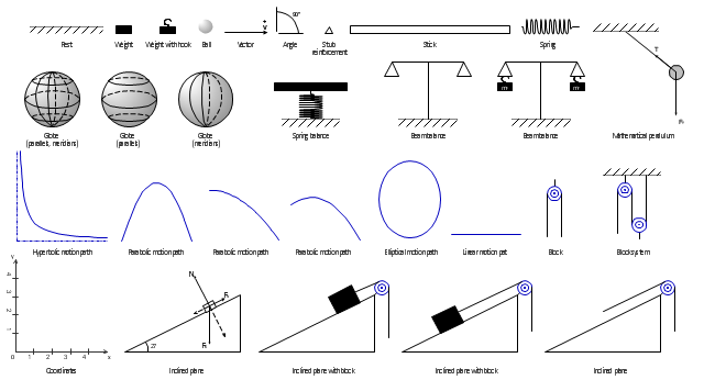
The vector stencils library "Mechanics" contains 29 symbol shapes for drawing mechanics experiment schemes and physical diagrams.
"Mechanics ... is the branch of science concerned with the behavior of physical bodies when subjected to forces or displacements, and the subsequent effects of the bodies on their environment. The scientific discipline has its origins in Ancient Greece with the writings of Aristotle and Archimedes. During the early modern period, scientists such as Galileo, Kepler, and especially Newton, laid the foundation for what is now known as classical mechanics. It is a branch of classical physics that deals with particles that are either at rest or are moving with velocities significantly less than the speed of light. It can also be defined as a branch of science which deals with the motion of and forces on objects." [Mechanics. Wikipedia]
The example "Design elements - Mechanics" was created using the ConceptDraw PRO diagramming and vector drawing software extended with the Physics solution from the Science and Education area of ConceptDraw Solution Park.
Mechanical symbols
The vector stencils library "Road signs" contains 58 symbols of traffic signs for labeling the road and route maps, street and locator maps, transit and directional maps using the ConceptDraw PRO diagramming and vector drawing software.
"Traffic signs or road signs are signs erected at the side of or above roads to give instructions or provide information to road users. ...
With traffic volumes increasing since the 1930s, many countries have adopted pictorial signs or otherwise simplified and standardized their signs to overcome language barriers, and enhance traffic safety. Such pictorial signs use symbols (often silhouettes) in place of words and are usually based on international protocols. Such signs were first developed in Europe, and have been adopted by most countries to varying degrees." [Traffic sign. Wikipedia]
The vector stencils library "Road signs" is included in the Directional Maps solution from the Maps area of ConceptDraw Solution Park.
Road signs

The vector stencils library "Landmarks" contains 34 signs and pictograms for drawing road and transit maps.
The vector stencils library "Map symbols" contains 10 signs and pictograms for drawing road and transit maps.
"A landmark is a recognizable natural or man-made feature used for navigation, a feature that stands out from its near environment and is often visible from long distances.
In modern use, the term can also be applied to smaller structures or features, that have become local or national symbols." [Landmark. Wikipedia]
The pictograms example "Design elements - Location map" was created using the ConceptDraw PRO diagramming and vector drawing software extended with the Spatial Infographics solution from the Maps area of ConceptDraw Solution Park.
Landmarks and Map symbols

- Hotel locator map | Rolla USGS Center locator map | Maps | Locator ...
- Landmarks - Vector stencils library | Hotel Plan. Hotel Plan ...
- Landmarks - Vector stencils library | How To use Building Plan ...
- Landmark Symbols For Shopping Malls
- Examples Of Stop Road Signs
- Landmarks - Vector stencils library | Design elements - Location ...
- Landmarks - Vector stencils library | Marina Sample Plans With ...
- Landmarks - Vector stencils library | Road Angle Parking Clipart
- Ferry
- Landmarks - Vector stencils library | Design elements - Landmarks ...
- 3D pictorial street map | Design elements - 3D directional maps ...
- Light Symbols
- Traffic Map 3d
- How To Draw A Road Without Traffic Signal
- Bus stop
- Hotel locator map
- Bathroom - Vector stencils library | Design elements - Bathroom ...
- Light Plan House
- First Floor Light