Geo Map - USA - New Hampshire

The vector stencils library New Hampshire contains contours for ConceptDraw PRO diagramming and vector drawing software. This library is contained in the Continent Maps solution from Maps area of ConceptDraw Solution Park.
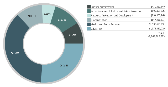
This donut chart example shows the citizens and taxpayers of New Hampshire how the State of New Hampshire spends their money they pay for their government.
The donut chart example "Budgeted appropriations" depicts how the New Hampshire's FY2014 Authorized Budget as enacted is allocated to the six categories of government.
The doughnut chart example "Budgeted appropriations" was redrawn from the official website of New Hampshire government. [www.nh.gov/ transparentnh/ where-the-money-goes/ ].
"Authorization and appropriations.
In general, funds for federal government programs must be authorized by an "authorizing committee" through enactment of legislation. Then, through subsequent acts by Congress, budget authority is then appropriated by the Appropriations Committee of the House. In principle, committees with jurisdiction to authorize programs make policy decisions, while the Appropriations Committees decide on funding levels, limited to a program's authorized funding level, though the amount may be any amount less than the limit.
The budget resolutions specify funding levels for the House and Senate Appropriations Committees and their 12 subcommittees, establishing various budget totals, allocations, entitlements, and may include reconciliation instructions to designated House or Senate committees. The appropriations committees, starting with allocations in the budget resolution, draft appropriations bills, which may be considered in the House after May 15. Once appropriations committees pass their bills, they are considered by the House and Senate. When there is a final budget, the spending available to each appropriations committee for the coming fiscal year is usually provided in the joint explanatory statement included in the conference report. The appropriations committees then allocate that amount among their respective subcommittees, each to allocate the funds they control among the programs within their jurisdiction." [United States budget process. Wikipedia]
The donut chart example "Budgeted appropriations" is created using the ConceptDraw PRO diagramming and vector drawing software extended with the Pie Charts solution of the Graphs and Charts area in ConceptDraw Solution Park.
www.conceptdraw.com/ solution-park/ charts-pie
Donut chart
Geo Map - USA - Maine

The vector stencils library Maine contains contours for ConceptDraw PRO diagramming and vector drawing software. This library is contained in the Continent Maps solution from Maps area of ConceptDraw Solution Park.
Geo Map - USA - Vermont

The vector stencils library Vermont contains contours for ConceptDraw PRO diagramming and vector drawing software. This library is contained in the Continent Maps solution from Maps area of ConceptDraw Solution Park.
Geo Map - USA - Massachusetts

The vector stencils library Massachusetts contains contours for ConceptDraw PRO diagramming and vector drawing software. This library is contained in the Continent Maps solution from Maps area of ConceptDraw Solution Park.
Geo Map - USA - New York

The vector stencils library New York contains contours for ConceptDraw PRO diagramming and vector drawing software. This library is contained in the Continent Maps solution from Maps area of ConceptDraw Solution Park.
Geo Map - USA - New Jersey

The vector stencils library New Jersey contains contours for ConceptDraw PRO diagramming and vector drawing software. This library is contained in the Continent Maps solution from Maps area of ConceptDraw Solution Park.
Geo Map - USA - New Mexico

The vector stencils library New Mexico contains contours for ConceptDraw PRO diagramming and vector drawing software. This library is contained in the Continent Maps solution from Maps area of ConceptDraw Solution Park.
Geo Map - USA - Pennsylvania

The vector stencils library Pennsylvania contains contours for ConceptDraw PRO diagramming and vector drawing software. This library is contained in the Continent Maps solution from Maps area of ConceptDraw Solution Park.
Geo Map - USA - Louisiana

The vector stencils library Louisiana contains contours for ConceptDraw PRO diagramming and vector drawing software. This library is contained in the Continent Maps solution from Maps area of ConceptDraw Solution Park.
Geo Map - USA - Connecticut

The vector stencils library Connecticut contains contours for ConceptDraw PRO diagramming and vector drawing software. This library is contained in the Continent Maps solution from Maps area of ConceptDraw Solution Park.
Geo Map - USA - Arizona

The vector stencils library Arizona contains contours for ConceptDraw PRO diagramming and vector drawing software. This library is contained in the Continent Maps solution from Maps area of ConceptDraw Solution Park.
Geo Map - USA - Delaware

The vector stencils library Delaware contains contours for ConceptDraw PRO diagramming and vector drawing software. This library is contained in the Continent Maps solution from Maps area of ConceptDraw Solution Park.
Geo Map - USA - Kansas

The vector stencils library Kansas contains contours for ConceptDraw PRO diagramming and vector drawing software. This library is contained in the Continent Maps solution from Maps area of ConceptDraw Solution Park.
Geo Map - USA - Arkansas

The vector stencils library Arkansas contains contours for ConceptDraw PRO diagramming and vector drawing software. This library is contained in the Continent Maps solution from Maps area of ConceptDraw Solution Park.
Geo Map - USA - Virginia

The vector stencils library Virginia contains contours for ConceptDraw PRO diagramming and vector drawing software. This library is contained in the Continent Maps solution from Maps area of ConceptDraw Solution Park.
Geo Map - USA - Utah

The vector stencils library Utah contains contours for ConceptDraw PRO diagramming and vector drawing software. This library is contained in the Continent Maps solution from Maps area of ConceptDraw Solution Park.
Geo Map - USA - Indiana

The vector stencils library Indiana contains contours for ConceptDraw PRO diagramming and vector drawing software. This library is contained in the Continent Maps solution from Maps area of ConceptDraw Solution Park.
Geo Map - USA - Wisconsin

The vector stencils library Wisconsin contains contours for ConceptDraw PRO diagramming and vector drawing software. This library is contained in the Continent Maps solution from Maps area of ConceptDraw Solution Park.
Geo Map - USA - Alabama

The vector stencils library Alabama contains contours for ConceptDraw PRO diagramming and vector drawing software. This library is contained in the Continent Maps solution from Maps area of ConceptDraw Solution Park.
- Geo Map - USA - New Hampshire
- Geo Map - USA - Maine | Geo Map - USA - New Hampshire | Geo ...
- Geo Map - USA - New York - Conceptdraw.com
- Geo Map - Canada - Quebec
- Geo Map - USA - New Mexico - Conceptdraw.com
- Geo Map - Canada - Quebec - Conceptdraw.com
- Geo Map - USA - Vermont - Conceptdraw.com
- Geo Map - America - United States | Geo Map - USA - Indiana | Geo ...
- Nature Drawings - How to Draw | Geo Map - USA - California | Geo ...
- Geo Map - USA - Massachusetts - Conceptdraw.com
- Geo Map - USA - New York - Conceptdraw.com
- Geo Map - America - United States | Design elements - USA | Geo ...
- Cubetto Flowchart | Work Order Process Flowchart. Business ...
- Geo Map - USA - New York
- Geo Map - America - United States
- Ring chart template | How to Create a Pie Chart | Arrow circle chart ...
- Pie Donut Chart. Pie Chart Examples
- Geo Map - USA - Colorado
- Geo Map - USA - Delaware | Geo Map - USA - New Jersey | Geo ...
- Chart Examples | Design elements - Pie charts | Donut chart template |