Geo Map — United States of America Map

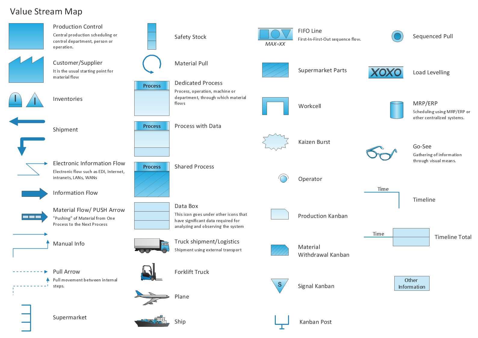
Learn how to create a current state value stream map
Geo Map - South America - Mexico

Geo Map of Americas

Geo Map - USA - Maryland

Geo Map - USA - California

Geo Map - Europe - Russia

HelpDesk
How to Draw a Map of USA States

 USA Maps
Use the USA Maps solution to create a map of USA, a US interstate map, printable US maps, US maps with cities and US maps with capitals. Create a complete USA states map.
Geo Map - USA - Maine

Geo Map — USA — Alaska

Geo Map - USA - West Virginia

The vector stencils library "Marketing maps" contains 44 state map contours with capitals and major cities: the Group of Twenty (G20) state maps, EU state maps and World map.
Use it to visualize geospatial information in your marketing infograms.
"The Group of Twenty (also known as the G-20 or G20) is a forum for the governments and central bank governors from 20 major economies. The members, shown highlighted on the map at right, include 19 individual countries—Argentina, Australia, Brazil, Canada, China, France, Germany, India, Indonesia, Italy, Japan, Republic of Korea, Mexico, Russian Federation, Saudi Arabia, South Africa, Turkey, United Kingdom, United States—and the European Union (EU). The EU is represented by the European Commission and by the ECB." [G-20 major economies. Wikipedia]
The G-20 state map contours example "Design elements - Marketing maps (G-20)" was created using the ConceptDraw PRO diagramming and vector drawing software extended with the Marketing Infographics solition from the area "Business Infographics" in ConceptDraw Solution Park.
The Group of Twenty (G-20) state maps
-state-maps-design-elements---marketing-maps-(g-20).png--diagram-flowchart-example.png)
Geo Map — USA — Washington

Geo Map — USA — Mississippi

- Geo Map - United States of America Map | Geo Map - USA - Alaska ...
- Geo Map - United States of America Map | USA Maps | Map of USA ...
- Geo Map - United States of America Map | USA Maps | Geo Map ...
- Geo Map - United States of America Map | How to Draw a Map of ...
- Geo Map - United States of America Map
- Benefit Corporation legislation - Thematic map | Ranks US states by ...
- Geo Map - United States of America Map | Geo Map - USA ...
- Nature Drawings - How to Draw | Geo Map - USA - California | Geo ...
- Geo Map - United States of America Map | Map of USA States | How ...
- USA Maps | Geo Map - United States of America Map | USA Maps ...
- Learn how to create a current state value stream map | Geo Map ...
- Map of USA with state names | Geo Map - United States of America ...
- Geo Map - United States of America Map | Continent Maps | Map of ...
- Geo Map - United States of America Map | Geo Map of Americas ...
- Geo Map - South America Continent | Geo Map - Asia | Geo Map ...
- Geo Map - United States of America Map | Andean states - Political ...
- USA Maps | Geo Map - United States of America Map | How to Draw ...
- Geo Map - United States of America Map | Map of USA with state ...
- Geo Map - United States of America Map | Geo Map - South America ...
- Geo Map - South America - Mexico | Geo Map - USA - Arizona | Geo ...