The vector stencils library "Marketing maps" contains 44 state map contours with capitals and major cities: the Group of Twenty (G20) state maps, EU state maps and World map.
Use it to visualize geospatial information in your marketing infograms.
"The Group of Twenty (also known as the G-20 or G20) is a forum for the governments and central bank governors from 20 major economies. The members, shown highlighted on the map at right, include 19 individual countries—Argentina, Australia, Brazil, Canada, China, France, Germany, India, Indonesia, Italy, Japan, Republic of Korea, Mexico, Russian Federation, Saudi Arabia, South Africa, Turkey, United Kingdom, United States—and the European Union (EU). The EU is represented by the European Commission and by the ECB." [G-20 major economies. Wikipedia]
The G-20 state map contours example "Design elements - Marketing maps (G-20)" was created using the ConceptDraw PRO diagramming and vector drawing software extended with the Marketing Infographics solition from the area "Business Infographics" in ConceptDraw Solution Park.
The Group of Twenty (G-20) state maps
-state-maps-design-elements---marketing-maps-(g-20).png--diagram-flowchart-example.png)
Geo Map of Americas

Geo Map — United States of America Map

Geo Map — South America Continent

Geo Map - South America - Nicaragua

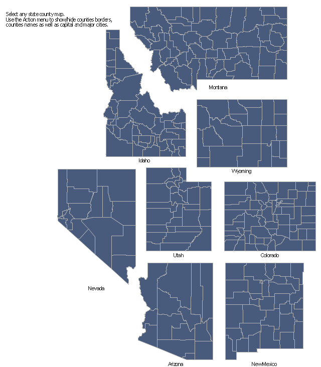
The vector stencils library "Map of US Mountain" contains 8 state maps of Arizona, Colorado, Idaho, Montana, Nevada, New Mexico, Utah, Wyoming with main cities and borders of counties.
Use it to design your U.S. thematic maps using the ConceptDraw PRO diagramming and vector drawing software.
The county map example "Design elements - Map of US Mountain" is included in the USA Maps solution from the Maps area of ConceptDraw Solution Park.
Use it to design your U.S. thematic maps using the ConceptDraw PRO diagramming and vector drawing software.
The county map example "Design elements - Map of US Mountain" is included in the USA Maps solution from the Maps area of ConceptDraw Solution Park.
County maps of Mountain states
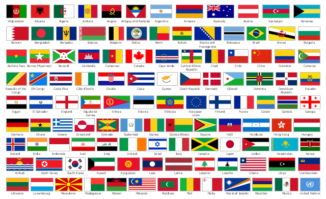
The vector stencils library "Flags" contains 204 clipart images of state flags.
The clip art example "Design elements - Flags" was created using the ConceptDraw PRO diagramming and vector drawing software extended with the Continent Maps solution from the Maps area of ConceptDraw Solution Park.
The clip art example "Design elements - Flags" was created using the ConceptDraw PRO diagramming and vector drawing software extended with the Continent Maps solution from the Maps area of ConceptDraw Solution Park.
State flags
Use the map contours library "South America" to design thematic maps of South American countries using the ConceptDraw PRO diagramming and vector drawing software.
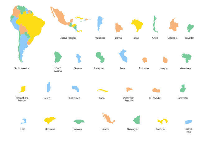
The vector stencils library "South America" contains 29 map contours: South America political map, Central America political map, state map contours of South American countries.
The map contours example "Design elements - South America" is included in the Continent Maps solution from the Maps area of ConceptDraw Solution Park.
South and Central America state map contours
 Continent Maps
Continent Maps solution extends ConceptDraw DIAGRAM software with templates, samples and libraries of vector stencils for drawing the thematic maps of continents, state maps of USA and Australia.
Geo Map - USA - Iowa

 USA Maps
Use the USA Maps solution to create a map of USA, a US interstate map, printable US maps, US maps with cities and US maps with capitals. Create a complete USA states map.
Geo Map - USA - Connecticut

Continents Map

Geo Map - South America - Mexico

- Design elements - Thematic maps | Geo Map - South America ...
- Political map of Central America | Design elements - North and ...
- Map of USA | North and Central America flags - Stencils library ...
- Spatial infographics Design Elements : Continental Map | Continents ...
- Design elements - North and Central America flags | Geo Map ...
- Design elements - North and Central America country flags | North ...
- Geo Map - United States of America Map | Design elements ...
- Languages of South America - Thematic map | Design elements ...
- Americas Map Design
- Continents and Oceans Map | Continents Map | Spatial infographics ...
- Design elements - South America | Geo Map - South America ...
- North and Central America flags - Stencils library | Design elements ...
- Mexico Flag
- North America Thematic Map
- Geo Map - Europe - Switzerland
- Geo Map - South America Continent
- Design elements - Education maps (EU) | Geo Map - Europe ...
- Design elements - Continental map | Geo Map - South America ...
- Geo Map - South America Continent | South America flags - Stencils ...
- Geo Map - South America Continent | Design elements - Marketing ...