"Spanish and Portuguese are the most spoken languages in South America, with approximately 200 million speakers each. Spanish is the official language of most countries, along with other native languages in some countries. Portuguese is the official language of Brazil. Dutch is the official language of Suriname; English is the official language of Guyana, although there are at least twelve other languages spoken in the country, including Hindi and Arabic. English is also spoken in the Falkland Islands. French is the official language of French Guiana and the second language in Amapá, Brazil.
Indigenous languages of South America include Quechua in Ecuador, Peru, Chile, Argentina, Colombia, and Bolivia; Wayuunaiki in northern Colombia (La Guajira); Guaraní in Paraguay and, to a much lesser extent, in Bolivia; Aymara in Bolivia, Peru, and less often in Chile; and Mapudungun is spoken in certain pockets of southern Chile and, more rarely, Argentina. At least three South American indigenous languages (Quechua, Aymara, and Guarani) are recognized along with Spanish as national languages." [South America. Wikipedia]
The Languages of South America map example was redesigned from Wikimedia Commons file: Languages of South America (en).svg.
[commons.wikimedia.org/ wiki/ File:Languages_ of_ South_ America_ (en).svg]
This file is licensed under the Creative Commons Attribution-Share Alike 3.0 Unported license. [creativecommons.org/ licenses/ by-sa/ 3.0/ deed.en]
The Languages of South America map example was drawn using ConceptDraw PRO diagramming and vector drawing software extended with design elements library South America.
The Languages of South America map example is included in the Continent Maps solution from the Maps area of ConceptDraw Solution Park.
Thematic map - South America

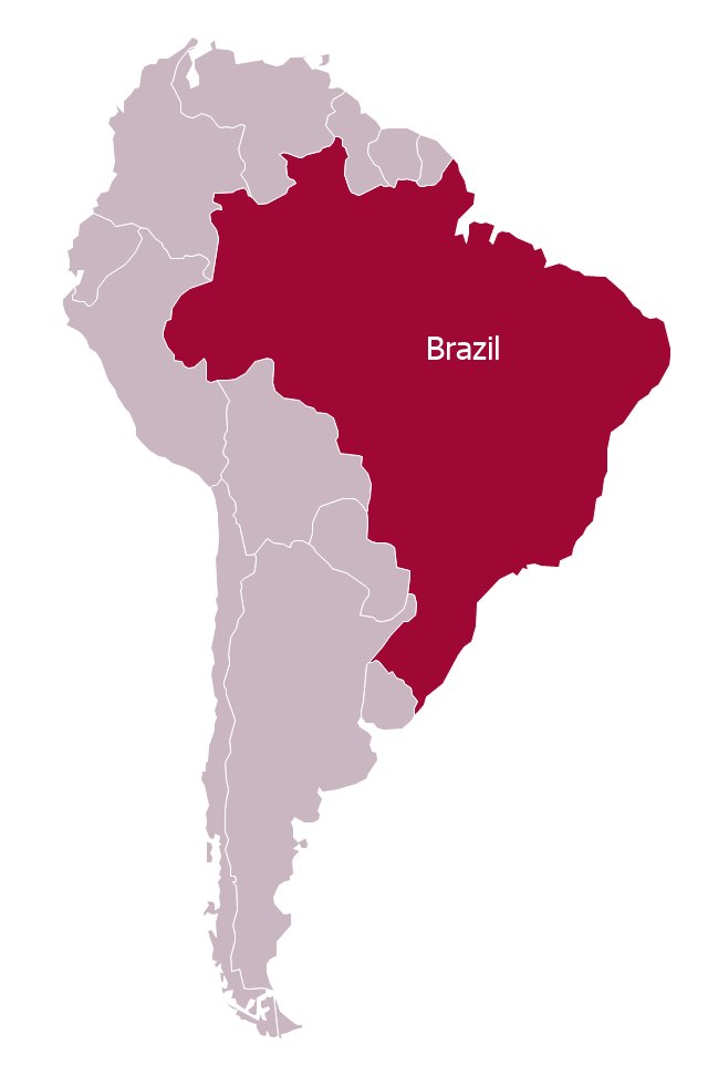
"Brazil ..., officially the Federative Republic of Brazil ... is the largest country in both South America and the Latin American region. It is the world's fifth largest country, both by geographical area and by population. It is the largest Lusophone country in the world, and the only one in the Americas.
Bounded by the Atlantic Ocean on the east, Brazil has a coastline of 7,491 km (4,655 mi). It is bordered on the north by Venezuela, Guyana, Suriname and the French overseas region of French Guiana; on the northwest by Colombia; on the west by Bolivia and Peru; on the southwest by Argentina and Paraguay and on the south by Uruguay. Numerous archipelagos form part of Brazilian territory, such as Fernando de Noronha, Rocas Atoll, Saint Peter and Paul Rocks, and Trindade and Martim Vaz. It borders all other South American countries except Ecuador and Chile and occupies 47 percent of the continent of South America." [Brazil. Wikipedia]
This Brazil in South America map was redesigned from Wikimedia Commons file: Brazil in South America (-mini map -rivers).svg. [commons.wikimedia.org/ wiki/ File:Brazil_ in_ South_ America_ (-mini_ map_ -rivers).svg]
This file is licensed under the Creative Commons Attribution-Share Alike 3.0 Unported license. [creativecommons.org/ licenses/ by-sa/ 3.0/ deed.en]
This Brazil in South America map example was drawn using ConceptDraw PRO diagramming and vector drawing software extended with design elements library South America. This example is included in the Continent Maps solution from the Maps area of ConceptDraw Solution Park.
Political map - Brazil in South America
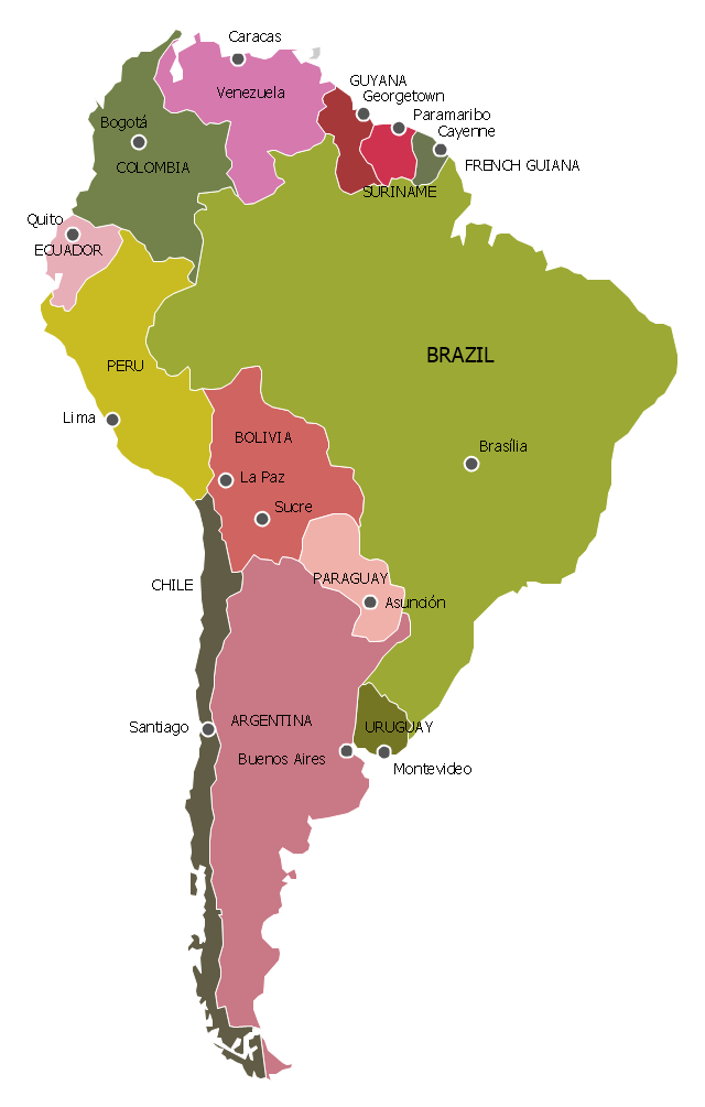
"South America is a continent located in the Western Hemisphere, mostly in the Southern Hemisphere, with a relatively small portion in the Northern Hemisphere. It can also be considered as a subcontinent of the Americas.
It is bordered on the west by the Pacific Ocean and on the north and east by the Atlantic Ocean; North America and the Caribbean Sea lie to the northwest. It includes twelve sovereign states – Argentina, Bolivia, Brazil, Chile, Colombia, Ecuador, Guyana, Paraguay, Peru, Suriname, Uruguay, and Venezuela – and two non-sovereign areas – French Guiana, an overseas department of France, and the Falkland Islands, a British Overseas Territory (though disputed by Argentina). In addition to this, the ABC islands of the Netherlands may also be considered part of South America. ... Countries and territories: Argentina, Bolivia, Brazil, Chile, Colombia, Ecuador, Falkland Islands (United Kingdom), French Guiana (France), Guyana, Paraguay, Peru, South Georgia and the South Sandwich Islands (United Kingdom), Suriname, Uruguay, Venezuela." [South America. Wikipedia]
This political map sample was redesigned from the Wikimedia Commons file: Map of South America.svg. [commons.wikimedia.org/ wiki/ File:Map_ of_ South_ America.svg]
This file is licensed under the Creative Commons Attribution-Share Alike 3.0 Unported license. [creativecommons.org/ licenses/ by-sa/ 3.0/ deed.en]
The example "South America - Political map" was created using the ConceptDraw PRO diagramming and vector drawing software extended with the Continent Maps solution from the Maps area of ConceptDraw Solution Park.
Political map - South America
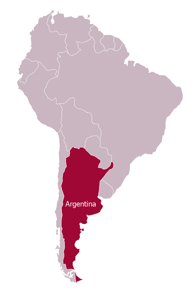
"Argentina..., officially the Argentine Republic..., is a federal republic located in southeastern South America. Covering most of the Southern Cone, it is bordered by Bolivia and Paraguay to the north, Brazil to the northeast, Uruguay and the Atlantic Ocean to the east, Chile to the west and the waters of the Drake Passage to the south." [Argentina. Wikipedia]
This Argentina in South America map was redesigned from Wikimedia Commons file: Argentina in South America (-mini map -rivers).svg.
[commons.wikimedia.org/ wiki/ File:Argentina_ in_ South_ America_ (-mini_ map_ -rivers).svg]
This file is licensed under the Creative Commons Attribution-Share Alike 3.0 Unported license. [creativecommons.org/ licenses/ by-sa/ 3.0/ deed.en]
The political map example "Argentina in South America" was drawn using the ConceptDraw PRO diagramming and vector drawing software extended with the design elements library South America. This example is included in the Continent Maps solution from the Maps area of ConceptDraw Solution Park.
Political map - Argentina in South America
Geo Map - South America - Peru

Geo Map of Americas

Map Software

Geo Map - Asia - Philippines

Geo Map - World

Geo Map - Asia - Kazakhstan

Geo Map - Africa - Uganda

Types of Map - Overview

Geo Map - Asia

Geo Map - Asia - Vietnam

Continent Map

- Geo Map - South America Continent | Languages of South America ...
- Geo Map - South America - Argentina
- Southern Cone - Political map | South America regions - Political ...
- Geo Map - South America Continent | Geo Map - United States of ...
- Languages of South America - Thematic map | Brazil in South ...
- South America - Political map | South America regions - Political ...
- Languages of South America - Thematic map | Geo Map - South ...
- Geo Map - South America - Argentina | Argentina in South America ...
- Geo Map - South America - Brazil | Brazil in South America - Political ...
- Middle East - Political map | South America - Political map | South ...
- Languages of South America - Thematic map | Design elements ...
- Languages of South America - Thematic map | South America map ...
- South America regions - Political map | Southern Cone - Political ...
- Geo Map - South America Continent | South America - Vector ...
- Languages of South America - Thematic map | North America map ...
- Argentina in South America - Political map | Geo Map - South ...
- Maghreb countries - Political map | Andean states - Political map ...
- Design elements - Continental map | Geo Map of Americas | Geo ...
- Geo Map - South America Continent | South America regions ...
- Languages of South America - Thematic map | The most spoken ...