Geo Map — South America Continent

Geo Map - Europe - Austria

 Illustration Area
Solutions from the Illustrations Area of ConceptDraw Solution Park collect templates, samples and libraries of color scalable vector stencils, icons and clip art for illustrating documents, presentations, infographics, web sites and blogs.
Geo Map - Africa

Geo Map — United States of America Map

 Website Wireframe
The innovative Website Wireframe solution enhances the ConceptDraw DIAGRAM functionality with newest wireframe tools, libraries with variety of predesigned icons, symbols, buttons, graphics, forms, boxes, and many other vector elements, templates and professionally designed samples, which make it the best wireframing software. Website Wireframe solution gives you significant advantages when designing and maintaining websites, creating skeletal and content-free depictions of website structure, making website prototypes and planning the content arrangement before committing to design, also speeds up the processes of sketching, producing and sharing wireframe examples of website style and interface design.
 Education Package
Education Package is a comprehensive set of multifarious graphical solutions from ConceptDraw Solution Park, collected together in help to ConceptDraw DIAGRAM users working in a field of science, education and training, which is aimed at improving the quality of education and helping to design with ease variety of interesting and colorful educational materials, diagrams, charts and maps. Use it to present the information and knowledge in an interesting, clear, structured and simple form to achieve a success in education and pedagogy, to maintain the interest of students and pupils throughout the whole learning process, at the lectures, lessons and even during independent work with additional materials, to contribute to better perception of scientific information by listeners during the conferences and reports.
Geo Map Software

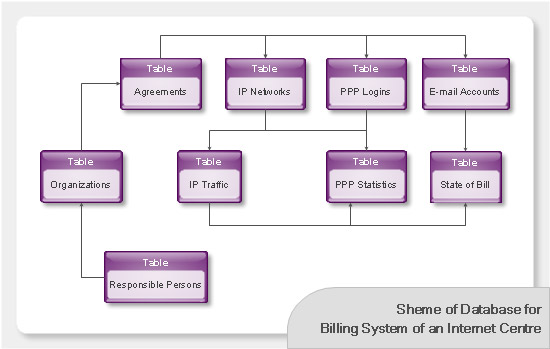
Databases Access Objects Model with ConceptDraw DIAGRAM
 Maps Area
Solutions from the Maps Area of ConceptDraw Solution Park collect templates, samples and libraries of vector stencils for drawing geographical, directional and transport maps.
Geo Map of Americas

 Australia Map
For graphic artists creating accurate maps of Australia. The Australia Map solution - allows designers to map Australia for their needs, offers a collection of scalable graphics representing the political geography of Australia, split into distinct state
Geo Map — USA — Oklahoma

Geo Map - South America - Nicaragua

- Geo Map - Africa | Flowchart design. Flowchart symbols , shapes ...
- Flowchart design. Flowchart symbols , shapes, stencils and icons ...
- Flowchart design. Flowchart symbols , shapes, stencils and icons ...
- Africa Icon
- Design elements - Fast food | South America flags - Stencils library ...
- Flowchart design. Flowchart symbols , shapes, stencils and icons ...
- Pakistan Flag Icon
- Flowchart design. Flowchart symbols , shapes, stencils and icons ...
- Goalkeeper Icon
- Design elements - Tab Bar Icons | iPhone interface - Vector stencils ...
- IVR Internet - Vector stencils library | Cloud round icons - Vector ...
- A single currency to boots the Single Market | Cloud round icons ...
- What is Cloud Computing | Cloud round icons - Vector stencils ...
- India Map Icon
- IVR Internet - Vector stencils library
- Cisco Routers. Cisco icons , shapes, stencils and symbols | Cisco ...
- Webpage Icon
- Milestone Icon Vector
- Website Wireframe | Basic Flowchart Symbols and Meaning | Design ...
- African Countries And Their Flag