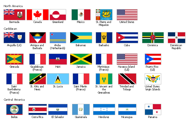
The vector stencils library "North and Central America flags" contains 35 state flags of North and Central American countries.
The clip art example "Design elements - North and Central America flags" was created using the ConceptDraw PRO diagramming and vector drawing software extended with the Continent Maps solution from the Maps area of ConceptDraw Solution Park.
The clip art example "Design elements - North and Central America flags" was created using the ConceptDraw PRO diagramming and vector drawing software extended with the Continent Maps solution from the Maps area of ConceptDraw Solution Park.
North and Central America state flags
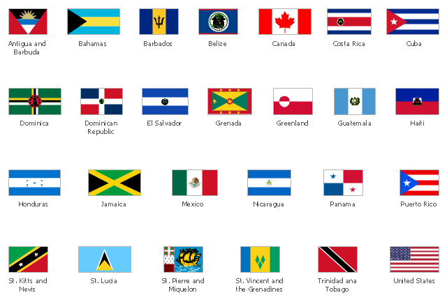
The vector stencils library "North and Central America country flags" contains 26 North and Central American state flags clipart.
Use this clip art library to illustrate your business documents, presentation slides, webpages, infographics.
The clip art example "Design elements - North and Central America country flags" was created using the ConceptDraw PRO diagramming and vector drawing software extended with the Artwork solution from the Illustration area of ConceptDraw Solution Park.
North and Central American state flags clip art
Geo Map — United States of America Map

Geo Map — South America Continent

Geo Map — South America Continent
Map Software

Geo Map - Africa

World Continents Map

 Continent Maps
Continent Maps solution extends ConceptDraw DIAGRAM software with templates, samples and libraries of vector stencils for drawing the thematic maps of continents, state maps of USA and Australia.
Geo Map of Americas

Geo Map — Asia

Geo Map — Europe — France

Map of Continents

Continents Map

- Design elements - North and Central America flags | Geo Map ...
- Design elements - North and Central America country flags | North ...
- Design elements - North and Central America flags | Design ...
- Design elements - North and Central America country flags
- Design elements - Europe flags | Design elements - European ...
- Design elements - North and Central America country flags | Geo ...
- South America country flags - Vector stencils library | Design ...
- Design elements - North and Central America flags
- Design elements - Africa flags | Design elements - South America ...
- Geo Map - South America Continent | South America flags - Stencils ...
- Design elements - Education maps (EU) | Geo Map - Europe ...
- North and Central America flags - Stencils library | Virgin Islands ...
- All Country Flags Of North America
- North and Central America flags - Stencils library | South America ...
- Design elements - South America flags | South America country ...
- Design elements - Oceania flags | Geo Map - South America - Chile ...
- Design elements - South America country flags | South America ...
- Flags - Stencils library | Design elements - Africa flags | Design ...
- North and Central America flags - Stencils library | Geo Map - South ...
- Design elements - Continental map | Geo Map of Americas | Geo ...