"Road maps come in many shapes, sizes and scales. Small, single-page maps may be used to give an overview of a region's major routes and features. ...
Highway maps generally give an overview of major routes within a medium to large region ranging from a few dozen to a few thousand miles or kilometers.
Street maps usually cover an area of a few miles or kilometers (at most) within a single city or extended metropolitan area. City maps are generally a specialized form of street map." [Road map. Wikipedia]
This 3D pictorial road map example was created using the ConceptDraw PRO diagramming and vector drawing software extended with the Directional Maps solution from the Maps area of ConceptDraw Solution Park.
3D Directional map

Directions Maps

The 3D pictorial street maps are used as road maps, route maps, locator maps, transit maps, directional maps, tourist maps with points of interest (POI).
"A point of interest, or POI, is a specific point location that someone may find useful or interesting. ...
Most consumers use the term when referring to hotels, campsites, fuel stations or any other categories used in modern (automotive) navigation systems. ...
The term is widely used in cartography, especially in electronic variants including GIS, and GPS navigation software. In this context the synonym waypoint is common.
A GPS point of interest specifies, at minimum, the latitude and longitude of the POI, assuming a certain map datum. A name or description for the POI is usually included, and other information such as altitude or a telephone number may also be attached. GPS applications typically use icons to represent different categories of POI on a map graphically." [Point of interest. Wikipedia]
The example "3D pictorial street map" was created using the ConceptDraw PRO diagramming and vector drawing software extended with the Directional Maps solution from the Maps area of ConceptDraw Solution Park.
3D pictorial street map

Map Directions

Directions Map

Maps and Directions

Map Infographic Creator

Audit Process Flowchart. Audit Flowchart

HelpDesk
How to Create a Directional Map Using ConceptDraw PRO

How To use House Electrical Plan Software


Aerospace - Design Elements

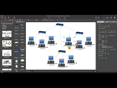
Star Network Topology

Examples of Flowcharts, Org Charts and More

Metropolitan area networks (MAN). Computer and Network Examples
. Computer and Network Examples")

The vector stencils library "Transport map" contains 96 pictograms for drawing transport maps.
Use it in your spatial infographics for visual representation of transport schemes and plans as metro maps in the ConceptDraw PRO diagramming and vector drawing software extended with the Spatial Infographics solution from the area "What is Infographics" of ConceptDraw Solution Park.
Use it in your spatial infographics for visual representation of transport schemes and plans as metro maps in the ConceptDraw PRO diagramming and vector drawing software extended with the Spatial Infographics solution from the area "What is Infographics" of ConceptDraw Solution Park.
Train Railway

Bus Stop

Tramlink

Marina/Ferry Dock

Information Center

Information Center

Airport

Airport

Underground/Subway/Metro

Underground/Subway/Metro

National Rail Train Station

Taxi

Taxi

Parking

Parking

Parking

Parking

Bicycle Parking

Bicycle Parking

Fuel/Gas/Petrol

Fuel/Gas/Petrol

Police

Police

Hospital

Hospital

Wheelchair Access

Wheelchair Access

First Aid

First Aid

Telephone

Telephone

Post Office

Post Office

Landmarks and Museums

Landmarks and Museums

University

University

Shopping/Supermarket

Shopping/Supermarket

Cafe

Cafe

Food and Drinks

Food and Drinks

Man

Woman

Restrooms/Toilets

Restrooms/Toilets

Park

Park

Zoo

Zoo

Hotel

Hotel

Camping

Camping

City

Skyscraper

Building

Ocean

Straight River

Flexible River

Bridge

North Arrow
Viewpoint

Scale

Road line

Road rounded line

Road corner

Road curve 1

Road curve 2

Crossroads

Roundabout

Cloverleaf interchange

Roadway break

Railway line

Railway curve

Railway fork

Standard line with standard station - basic road

Thick line with standard station - basic road

Standard line with rectangular station - basic road

Thick line with rectangular station - basic road

Standard line with standard station - double road

Thick line with standard station - double road

Standard line with rectangular station - double road

Thick line with rectangular station - double road

Standard line with standard station - dotted road

Thick line with standard station - dotted road

Standard line with rectangular station - dotted road

Thick line with rectangular station - dotted road

Interchange Station Vertical

Interchange Station Horizontal

Transfer Station 1

Transfer Station 2

Transfer Station 3

Line Notation

Street direction

- Infographic software: the sample of New York City Subway map ...
- Road Transport - Design Elements | 3D pictorial street map ...
- 3D pictorial road map | 2D Directional map - Template | Map ...
- 3d City Map Vector
- 3d Map Tree Examples
- 3D pictorial street map | 3D pictorial road map | Design elements ...
- Geo Map - Africa - Rwanda | Design elements - 3D directional maps ...
- 3D pictorial road map | ARL route map | Rolla USGS Center locator ...
- 3D pictorial street map | Design elements - 3D directional maps ...
- Directional Maps | How to Create a Directional Map Using ...
- 3D pictorial road map | Flow chart Example. Warehouse Flowchart ...
- 3D pictorial road map | Design elements - 3D directional maps | 3D ...
- 3D pictorial road map | 2D Directional map - Template | Design ...
- Design elements - 3D directional maps | 3D pictorial road map ...
- Design elements - 3D directional maps | How to draw Metro Map ...
- Map Directions | How to draw Metro Map style infographics? (New ...
- 3D pictorial road map | Road transport - Vector stencils library ...
- Advertising - Design Elements | 3D pictorial street map | Geo Map ...
- Design elements - 3D directional maps | Landmarks - Vector stencils ...
- Design elements - 3D directional maps | Directional Maps | 3D ...