Use this Africa map template to design your political or thematic map.
This Africa map template for the ConceptDraw PRO diagramming and vector drawing software is included in the Continent Maps solution from the Maps area of ConceptDraw Solution Park.
This Africa map template for the ConceptDraw PRO diagramming and vector drawing software is included in the Continent Maps solution from the Maps area of ConceptDraw Solution Park.
Africa map

Use this template of North America map with contours of North American countries, capitals and main cities to design your political or thematic map. This North America map template for the ConceptDraw PRO diagramming and vector drawing software is included in the Continent Maps solution from the Maps area of ConceptDraw Solution Park.
North America map template

Maps of Germany With Cities

Use this template of Europe map with contours of European countries, capitals and main cities to design your political or thematic map.
This Europe map template for the ConceptDraw PRO diagramming and vector drawing software is included in the Continent Maps solution from the Maps area of ConceptDraw Solution Park.
This Europe map template for the ConceptDraw PRO diagramming and vector drawing software is included in the Continent Maps solution from the Maps area of ConceptDraw Solution Park.
Europe map template

UK Map

Use this template of South America map with contours of South American countries, capitals and main cities to design your political or thematic map. This South America map template for the ConceptDraw PRO diagramming and vector drawing software is included in the Continent Maps solution from the Maps area of ConceptDraw Solution Park.
South America map

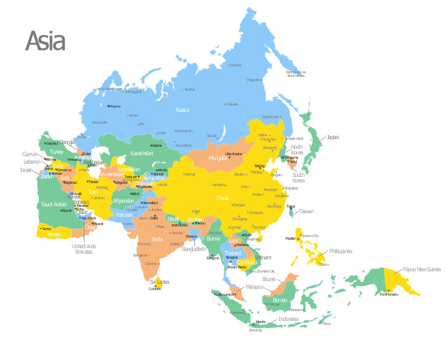
Use this template of Asia map with contours of Asian countries, capitals and main cities to design your political or thematic map.
This Asia map template for the ConceptDraw PRO diagramming and vector drawing software is included in the Continent Maps solution from the Maps area of ConceptDraw Solution Park.
This Asia map template for the ConceptDraw PRO diagramming and vector drawing software is included in the Continent Maps solution from the Maps area of ConceptDraw Solution Park.
Asia map
Map of USA States

 Australia Map
For graphic artists creating accurate maps of Australia. The Australia Map solution - allows designers to map Australia for their needs, offers a collection of scalable graphics representing the political geography of Australia, split into distinct state
Map of Germany — Brandenburg State

Map of Germany

USA Map

Germany Map

Map of Germany — Bavaria State

- Africa map with countries, main cities and capitals - Template ...
- Africa map with countries, main cities and capitals - Template | Africa ...
- Africa map with countries, main cities and capitals - Template | Geo ...
- Africa map with countries, main cities and capitals - Template | South ...
- Africa map with countries, main cities and capitals - Template
- Africa map with countries, main cities and capitals - Template | Maps ...
- Africa map with countries, main cities and capitals - Template | Geo ...
- Africa map - Template | Africa map with countries, main cities and ...
- Geo Map - South America Continent | North America Capital Cities ...
- Europe map with capitals - Template | Continents Map | Maps of ...
- Europe map with capitals - Template | Geo Map - Europe - Ukraine ...
- Geo Map - Africa | Africa map with countries, main cities and capitals ...
- Geo Map - Asia - Philippines | Asia map with capitals - Template ...
- Australia map with cities - Template | Australia map - Template ...
- South American Countries And Capital Cities
- Geo Map - Europe - Germany | Europe map with capitals - Template ...
- Geo Map - South America Continent | Capital Cities Of North ...
- Map Of South America With Capital Cities
- North America map with capitals - Template | South America map ...
- North And South America Cities Map