Geo Map — Asia — Vietnam

Geo Map - Asia - Bangladesh

Geo Map - Asia - South Korea
Geo Map - Asia - Japan

Geo Map - Asia - Singapore

 Continent Maps
Continent Maps solution extends ConceptDraw DIAGRAM software with templates, samples and libraries of vector stencils for drawing the thematic maps of continents, state maps of USA and Australia.
Geo Map - Asia - Kuwait

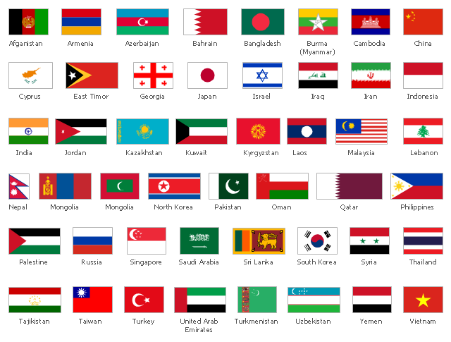
The vector stencils library "Asian country flags" contains 48 clipart images of Asia state flags.
Use it to illustrate your business documents, presentation slides, web pages and infographics.
The clip art example "Design elements - Asian country flags" was created using the ConceptDraw PRO diagramming and vector drawing software extended with the Artwork solution from the Illustration area of ConceptDraw Solution Park.
Asia state flags clip art
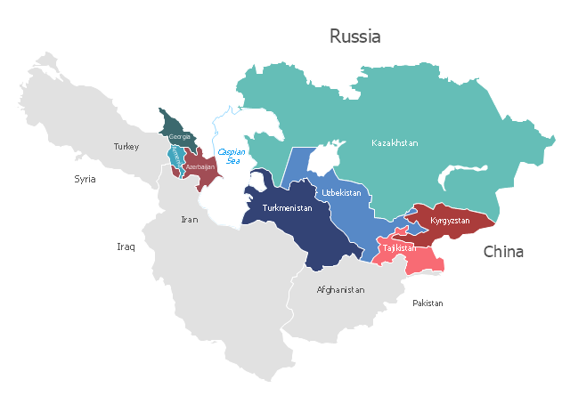
"Central Asia is the core region of the Asian continent and stretches from the Caspian Sea in the west to China in the east and from Afghanistan in the south to Russia in the north. It is also sometimes referred to as Middle Asia, and, colloquially, "the 'stans" (as the five countries generally considered to be within the region all have names ending with the Persian suffix "-stan", meaning "land of") and is within the scope of the wider Eurasian continent.
In modern contexts, all definitions of Central Asia include these five republics of the former Soviet Union: Kazakhstan ..., Kyrgyzstan ..., Tajikistan ..., Turkmenistan ..., and Uzbekistan ... Other areas sometimes included are Afghanistan, Mongolia, eastern Iran, and northwestern Pakistan, and sometimes Xinjiang and Tibet in western China, the Kashmir region of northern India and northern Pakistan, and southern Siberia in southern Russia." [Central Asia. Wikipedia]
This Central Asia political map was redesigned from Wikimedia Commons file: Central Asia - political map - 2000.svg.
[commons.wikimedia.org/ wiki/ File:Central_ Asia_ -_ political_ map_ -_ 2000.svg]
This file is licensed under the Creative Commons Attribution-Share Alike 3.0 Unported license. [creativecommons.org/ licenses/ by-sa/ 3.0/ deed.en]
The political map example "Central Asia" was drawn using the ConceptDraw PRO diagramming and vector drawing software extended with the design elements library Asia.
The political map example "Central Asia" is included in the Continent Maps solution from the Maps area of ConceptDraw Solution Park.
Political map - Central Asia

"Central Asia is the core region of the Asian continent and stretches from the Caspian Sea in the west to China in the east and from Afghanistan in the south to Russia in the north. It is also sometimes referred to as Middle Asia, and, colloquially, "the 'stans" (as the six countries generally considered to be within the region all have names ending with the Persian suffix "-stan", meaning "land of") and is within the scope of the wider Eurasian continent.
In modern contexts, all definitions of Central Asia include these five republics of the former Soviet Union: Kazakhstan (pop. 17.9 million), Kyrgyzstan (5.8 million), Tajikistan (8.0 million), Turkmenistan (5.2 million), and Uzbekistan (30.2 million), for a total population of 67.1 million as of 2013-2014. Afghanistan (pop. 31.1 million) is also sometimes included." [Central Asia. Wikipedia]
"The Caucasus / ˈkɔːkəsəs/ or Caucasia / kɔːˈkeɪʒə/ (for endonyms, see below), is a region at the border of Europe and Asia, situated between the Black and the Caspian seas. It is home to the Caucasus Mountains, which contain Europe's highest mountain, Mount Elbrus. Politically, the Caucasus region is separated between northern and southern parts. The southern parts consist of independent sovereign states: Abkhazia, Armenia, Azerbaijan, Georgia, Nagorno-Karabakh, South Ossetia, Turkey (part), Iran (part). The northern parts are under the jurisdiction of the Russian Federation." [Caucasus. Wikipedia]
This political map sample was redesigned from the Wikimedia Commons file: Caucasus central asia political map 2000.jpg. [commons.wikimedia.org/ wiki/ File:Caucasus_ central_ asia_ political_ map_ 2000.jpg]
The example "Caucasus and Central Asia 2000 - Political map" was created using the ConceptDraw PRO diagramming and vector drawing software extended with the Continent Maps solution from the Maps area of ConceptDraw Solution Park.
Political map - Caucasus and Central Asia 2000
Geo Map — United States of America Map

Map of Germany

UK Map

Geo Map - Europe - Macedonia

Geo Map - Europe - Serbia

- Names Of Asian Countries
- Design elements - Asian country flags | Geo Map - Asia - Kuwait ...
- Asian Countries Country Name With National Flag Dh Pic
- Draw A Flag Of Some African And Asian Countries With Country Name
- Asia Country Names
- Europe Countries Flags With Names
- Geo Map - Asia | List Asian Cuntry
- Asian Country Picture
- Flags And Their Names
- All The State Flags With Their Names
- Maghreb Countries Names
- Asian Continents Countries
- Mainland Southeast Asia Consists Of What Six Countries
- Country Map
- Design elements - Asia flags | Asia flags - Stencils library | Design ...
- All Flags With Names And Pictures
- Central Asian Countries Map
- List Of All Asian Countries
- Map of Germany | Geo Map - United States of America Map | Geo ...
- Geo Map - Asia