Geo Map - Africa

Use the map contours library Africa to design thematic maps of African countries using the ConceptDraw PRO diagramming and vector drawing software.
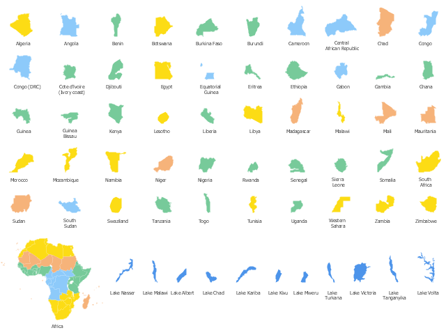
The design elements library Africa contains 122 African state map contours, Africa political map and biggest lakes contours.
The vector stencils library "Africa" is included in the Continent Maps solution from the Maps area of ConceptDraw Solution Park.
The design elements library Africa contains 122 African state map contours, Africa political map and biggest lakes contours.
The vector stencils library "Africa" is included in the Continent Maps solution from the Maps area of ConceptDraw Solution Park.
African countries map contours
The vector stencils library "African country flags" contains 54 Africa state flags clipart.
Use it to illustrate your business documents, presentation slides, web pages and infographics.
The clip art example "Design elements - African country flags" was created using the ConceptDraw PRO diagramming and vector drawing software extended with the Artwork solution from the Illustration area of ConceptDraw Solution Park.
African state flags clip art

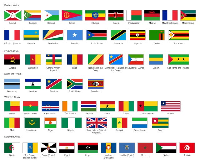
The vector stencils library "Africa flags" contains 61 clipart images of African countries state flags.
State flags of East Africa (Eastern Africa) countries and territories: Burundi, Comoros, Djibouti, Eritrea, Ethiopia, Kenya, Madagascar, Malawi, Mayotte (France), Mozambique, Réunion (France), Rwanda, Seychelles, Somalia, South Sudan, Tanzania, Uganda, Zambia, Zimbabwe.
State flags of Central Africa countries: Angola, Cameroon, Central African Republic, Chad, Republic of the Congo, Democratic Republic of the Congo, Equatorial Guinea, Gabon, São Tomé and Príncipe.
State flags of Southern Africa countries: Botswana, Lesotho, Namibia, South Africa, Swaziland.
State flags of West Africa (Western Africa) countries and territories: Benin, Burkina Faso, Cape Verde, Côte d'Ivoire, Gambia, Ghana, Guinea, Guinea-Bissau, Liberia, Mali, Mauritania, Niger, Nigeria, Saint Helena (United Kingdom), Senegal, Sierra Leone, Togo.
State flags of North Africa (Northern Africa) countries and territories: Algeria, The Canary Islands (Spain), Ceuta (Spain), Egypt, Libya, Madeira (Portugal), Melilla (Spain), Morocco, Sudan, Tunisia.
The clip art example "Design elements - Africa flags" was created using the ConceptDraw PRO diagramming and vector drawing software extended with the Continent Maps solution from the Maps area of ConceptDraw Solution Park.
Africa state flags
Geo Map - Africa - Tanzania

Geo Map - Africa - Chad

Geo Map - Africa - Morocco

Geo Map - Africa - Uganda

Geo Map - Africa - Senegal

Geo Map - Africa - South Sudan

Geo Map - Africa - Algeria

Geo Map - Africa - Congo

Geo Map - Africa - Central African Republic

Geo Map - Africa - Libya

Geo Map - Africa - Kenya

- Africa flags - Stencils library | Banner Png Black And White
- Education pictograms - Vector stencils library | Bus Flat Design Png
- Africa Map Png
- Geo Map - Africa - Nigeria | West Africa countries | Africa - Vector ...
- West Africa Map Png
- Geo Map - Africa - Madagascar | East Africa - Political map | Geo ...
- Map Of Nigeria Png
- High Quality Map Of Africa Png
- Geo Map - Africa - Angola | Africa - Vector stencils library | Geo Map ...
- Design elements - Dessert | Healthy Food Ideas | Dinner Recipes ...
- Morocco Map Vector Png
- Education pictograms - Vector stencils library | Dna Png Flat Design
- Pen Flat Design Png
- Dna Logo Design Png
- Grape Flat Design Png
- Paper And Pencil Flat Design Png
- Design elements - Ponds and Fountains | Landscape Plan | Modern ...
- Bulb Flat Design Png
- Ruler Flat Design Png
- South America regions - Political map | East Africa - Political map ...