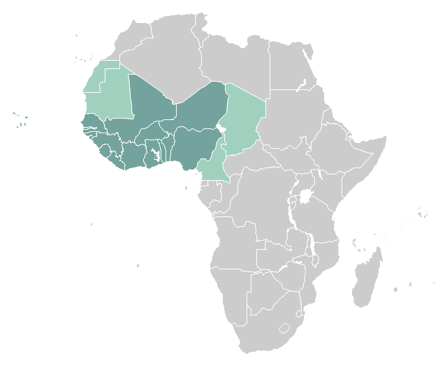
"West Africa, also called Western Africa and the West of Africa, is the westernmost region of the African continent. In line with the current membership of the Economic Community of West African States (ECOWAS), West Africa has been defined in Africa as including the fifteen countries of Benin, Burkina Faso, Cape Verde, Gambia, Ghana, Guinea, Guinea-Bissau, Ivory Coast, Liberia, Mali, Niger, Nigeria, Senegal, Sierra Leone and Togo." [West Africa. Wikipedia]
This example West Africa countries map was redesigned from the Wikimedia Commons file: Afryka Zachodnia.png.
[commons.wikimedia.org/ wiki/ File:Afryka_ Zachodnia.png]
The political map example "West Africa countries" was created using ConceptDraw PRO diagramming and vector drawing software extended with the Continent Map solution from the Maps area of ConceptDraw Solution Park.
Political map - West Africa
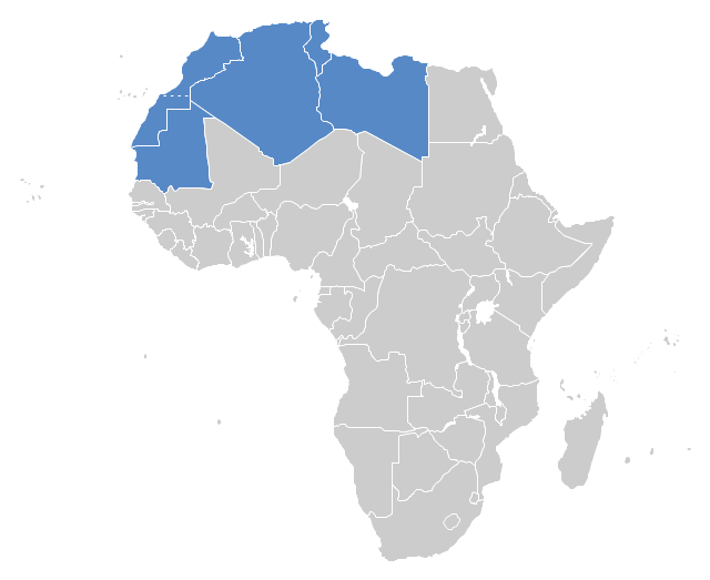
"The Maghreb is usually defined as much or most of the region of Northwest Africa, west of Egypt. The traditional definition as being the region including the Atlas Mountains and the coastal plains of Morocco, Algeria, Tunisia, and Libya, was later superseded, especially since the 1989 formation of the Arab Maghreb Union, by the inclusion of Mauritania and of the disputed territory of Western Sahara (mostly controlled by Morocco)." [Maghreb. Wikipedia]
This Maghreb map example was redesigned using ConceptDraw PRO diagramming and vector drawing software from the Wikimedia Commons file: Maghreb.png.
[commons.wikimedia.org/ wiki/ File:Maghreb.png]
The political map example "Maghreb countries" is included in the Continent Map solution from Maps area of ConceptDraw Solution Park.
Political map - Maghreb countries
"East Africa or Eastern Africa is the easterly region of the African continent, variably defined by geography or geopolitics. In the UN scheme of geographic regions, 20 territories constitute Eastern Africa:
- Tanzania, Kenya, Uganda, Rwanda and Burundi – in Southeast Africa included in the African Great Lakes region and are members of the East African Community (EAC). Burundi and Rwanda are sometimes considered part of Central Africa.
- Djibouti, Eritrea, Ethiopia and Somalia – collectively known as the Horn of Africa.
- Mozambique and Madagascar – often considered part of Southern Africa. Madagascar has close cultural ties to Southeast Asia and the islands of the Indian Ocean.
- Malawi, Zambia and Zimbabwe – often included in Southern Africa, and formerly of the Central African Federation.
- Comoros, Mauritius and Seychelles – small island nations in the Indian Ocean.
- Réunion and Mayotte – French overseas territories also in the Indian Ocean.
- South Sudan – newly independent from Sudan." [East Africa. Wikipedia]
South Sudan has become independent on July 9, 2011. Sudan and South Sudan are shown with the new international border between them.
This East Africa political map was redesigned using the ConceptDraw PRO diagrammin and vector drawing software from the Wikimedia Commons file: Afryka Wschodnia.png.
[commons.wikimedia.org/ wiki/ File:Afryka_ Wschodnia.png]
The example "East Africa - Political map" is included in the Continent Maps solution from the Maps area of ConceptDraw Solution Park.
Political map - East Africa

Geo Map - Africa - Guinea

Geo Map — Asia — Indonesia

Geo Map - Asia - Papua New Guinea

Geo Map - Africa

Geo Map - Africa - Burkina Faso

Geo Map - Africa - Kenya

Geo Map - Africa - Senegal

Geo Map - Africa - Algeria

Geo Map — Africa — Tanzania

Geo Map - Africa - Chad

Geo Map - Africa - Uganda

Geo Map - Africa - South Sudan

- Geo Map - Africa - Nigeria
- East Africa - Political map | West Africa countries | Geo Map - Africa ...
- West Africa Map Png
- Geo Map - Africa - Nigeria | West Africa countries | Geo Map - Africa ...
- Map Of Nigeria Png
- Geo Map - Africa - Ghana | West Africa countries | Geo Map - Africa ...
- East Africa - Political map | West Africa countries | Geo Map - Asia ...
- Maghreb countries - Political map | Geo Map - Africa - Morocco | Geo ...
- Maghreb countries - Political map
- High Quality Map Of Africa Png
- Geo Map - Africa - Cote d'Ivoire | West Africa countries | Geo Map ...
- Maghreb countries - Political map | Continent Maps | Geo Map ...
- West Africa countries | Geo Map - Africa - Nigeria | Africa - Vector ...
- Geo Map - Africa | Geo Map - Asia - Papua New Guinea | Spatial ...
- West Africa Countries Map
- Geo Map - Africa - Tunisia | Maghreb countries - Political map | Geo ...
- Africa - Vector stencils library | East Africa - Political map | West ...
- Geo Map - Africa - Nigeria | West Africa countries | Geo Map - Africa ...
- Nigera Map Png
- South America regions - Political map | East Africa - Political map ...