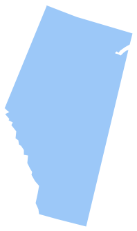
Geo Map - Canada - Alberta
Maps of Canada - Alberta
"Alberta is a province of Canada. With a population of 3,645,257 in 2011 and an estimated population of 4,025,074 in 2013, it is Canada's fourth-most populous province and most populous of Canada's three prairie provinces. Alberta and its neighbour, Saskatchewan, were established as provinces on September 1, 1905." [Alberta. Wikipedia]
The vector stencils library Alberta contains contours for ConceptDraw DIAGRAM diagramming and vector drawing software. This library is contained in the Continent Maps solution from Maps area of ConceptDraw Solution Park.
Use the Alberta library to draw thematic maps, geospatial infographics and vector illustrations for your business documents, presentations and websites.
Geo Map - Canada - Alberta
Geo Map - Canada - Alberta Contour

Geo Map - Canada

Geo Map - Canada Contour

Geo Map - contours of Canada provinces and territories

See also Geo Maps of Canada provinces and territories :
THREE RELATED HOW TO's:
No one can imagine a geography class without such educational stuff as a geo map or a globe. As for one of the biggest countries in North America, the United States of America Map is present in every American school or college. It’s easier to remember all the states if you look on the map more often.
The following sample represents the map of USA. This precise map has names of all states of America. The different colors which are used to indicate each state add the visuality and brightness to the whole map. The ConceptDraw USA Maps solution - one of a family of ConceptDraw Maps solutions. Any country invokes a big piece of data: geographical, political, statistical, etc. A simple way of representing this data is to design maps that will show a certain item in relation to a particular area of Earth.
Picture: How to Draw the US Map? ConceptDraw Diagram Software for Easy USA Map Drawing
Related Solution:
British Columbia, also commonly referred to by its initials BC or B.C.
The vector stencils library British Columbia contains contours for ConceptDraw DIAGRAM diagramming and vector drawing software. This library is contained in the Continent Maps solution from Maps area of ConceptDraw Solution Park.
Picture: Geo Map - Canada - British Columbia
Related Solution:
Maine is a state in the New England region of the northeastern United States, bordered by the Atlantic Ocean to the east and south; New Hampshire to the west; the Canadian provinces of Quebec to the northwest; and New Brunswick to the northeast.
The vector stencils library Maine contains contours for ConceptDraw DIAGRAM diagramming and vector drawing software. This library is contained in the Continent Maps solution from Maps area of ConceptDraw Solution Park.
Picture: Geo Map — USA — Maine
Related Solution:


