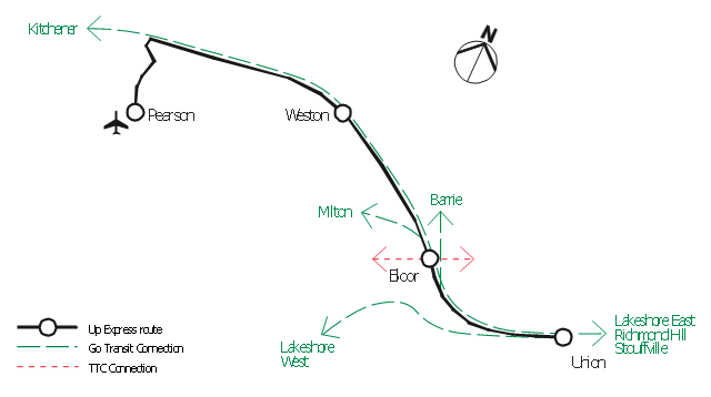
"An airport rail link is a service providing passenger rail transport from an airport to a nearby city; by mainline- or commuter trains, rapid transit, people mover or light rail. Direct links operate straight to the airport terminal, while other systems require an intermediate use of people mover or shuttle bus.
Although airport rail links have been popular solutions in Europe and Japan for decades, only recently have links been constructed in North America and Oceania, and the rest of Asia. Advantages for the rider include faster travel time and easy interconnection with other public transport, while authorities have benefited from less highway and parking congestion, less pollution, and additional business opportunities. Additionally, the links benefit airports by drawing in more passengers via easy access." [Airport rail link. Wikipedia]
This route map example was redesigned from the Wikimedia Commons file: ARL route map.png. [commons.wikimedia.org/ wiki/ File:ARL_ route_ map.png]
This file is made available under the Creative Commons CC0 1.0 Universal Public Domain Dedication. [creativecommons.org/ publicdomain/ zero/ 1.0/ deed.en]
The example "ARL route map" was created using the ConceptDraw PRO diagramming and vector drawing software extended with the Metro Map solution from the Maps area of ConceptDraw Solution Park.
Route map
The vector stencils library "Map symbols" contains 19 symbols for labeling the maps.
The pictograms example "Map symbols - Vector stencils library" was created using the ConceptDraw PRO diagramming and vector drawing software extended with the Directional Maps solution from the Maps area of ConceptDraw Solution Park.
The pictograms example "Map symbols - Vector stencils library" was created using the ConceptDraw PRO diagramming and vector drawing software extended with the Directional Maps solution from the Maps area of ConceptDraw Solution Park.
Compass

North

North arrow 1
North arrow 2
North arrow 3
North arrow 4
North arrow 5
Scale

Scale symbol 1

Scale symbol 2

Horizontal

Vertical

Callout

Church

Cathedral

Viewpoint

Castle

Ruins

Curiosity

The vector stencils library "Map symbols" contains 19 symbols for labeling the maps.
The pictograms example "Map symbols - Vector stencils library" was created using the ConceptDraw PRO diagramming and vector drawing software extended with the Directional Maps solution from the Maps area of ConceptDraw Solution Park.
The pictograms example "Map symbols - Vector stencils library" was created using the ConceptDraw PRO diagramming and vector drawing software extended with the Directional Maps solution from the Maps area of ConceptDraw Solution Park.
Compass
North
North arrow 1
North arrow 2
North arrow 3
North arrow 4
North arrow 5
Scale
Scale symbol 1
Scale symbol 2
Horizontal
Vertical
Callout
Church
Cathedral
Viewpoint
Castle
Ruins
Curiosity
The vector stencils library "Map symbols" contains 10 spatial infographics symbols.
Use these signs and pictograms for drawing road and transit maps in the ConceptDraw PRO diagramming and vector drawing software extended with the Spatial Infographics solution from the area "What is Infographics" of ConceptDraw Solution Park.
Use these signs and pictograms for drawing road and transit maps in the ConceptDraw PRO diagramming and vector drawing software extended with the Spatial Infographics solution from the area "What is Infographics" of ConceptDraw Solution Park.
Windrose

North arrow
North arrow
Callout

Callout

Location

Direction Right

Direction Left

Direction Up

Direction Down

The vector stencils library "Map symbols" contains 10 spatial infographics symbols.
Use these signs and pictograms for drawing road and transit maps in the ConceptDraw PRO diagramming and vector drawing software extended with the Spatial Infographics solution from the area "What is Infographics" of ConceptDraw Solution Park.
Use these signs and pictograms for drawing road and transit maps in the ConceptDraw PRO diagramming and vector drawing software extended with the Spatial Infographics solution from the area "What is Infographics" of ConceptDraw Solution Park.
Windrose
North arrow
North arrow
Callout
Callout
Location
Direction Right
Direction Left
Direction Up
Direction Down
The vector stencils library "Landmarks" contains 69 landmark symbols of buildings, waterways, scale and directional indicators for labeling transportation and directional maps, road and route maps, street and transit maps, locator and tourist maps.
The pictograms example "Landmarks - Vector stencils library" was created using the ConceptDraw PRO diagramming and vector drawing software extended with the Directional Maps solution from the Maps area of ConceptDraw Solution Park.
The pictograms example "Landmarks - Vector stencils library" was created using the ConceptDraw PRO diagramming and vector drawing software extended with the Directional Maps solution from the Maps area of ConceptDraw Solution Park.
Viewpoint

North arrow
North arrow
Building

Building

Town house

Suburban home

Skyscraper

Town hall

Public house

Petrol station

Gas station

Factory

School

Warehouse

Hospital

Fire station

Train station

Condos

Barn

Motel

Convenience store

Shopping centre

City

Church

Cathedral

National tail train station

Train railway

Bus stop

Tramlink

Marina / Ferry dock

Car ferry

Stop light

Airport

Airport

Underground / Subway / Metro

Taxi

Bicycle parking

Parking

Fuel / Gas / Petrol

Police

Hospital

Wheelchair access

First aid

Telephone

Post office

Landmarks and museums

University

Shopping

Refreshments / Public House

Restrooms / Toilets

Park

Zoo

Information center

Stadium 1

Stadium 2

Park

Tree

Fir-tree

Ocean

Lake

River

Angled river

Forked river

Curved river

Curved river

Flexible river

Bridge

Scale

The vector stencils library "Map symbols" contains 10 spatial infographics symbols.
Use these signs and pictograms for drawing road and transit maps in the ConceptDraw PRO diagramming and vector drawing software extended with the Spatial Infographics solution from the area "What is Infographics" of ConceptDraw Solution Park.
Use these signs and pictograms for drawing road and transit maps in the ConceptDraw PRO diagramming and vector drawing software extended with the Spatial Infographics solution from the area "What is Infographics" of ConceptDraw Solution Park.
Windrose
North arrow
North arrow
Callout
Callout
Location
Direction Right
Direction Left
Direction Up
Direction Down
The vector stencils library "Map symbols" contains 19 symbols for labeling the maps.
The pictograms example "Map symbols - Vector stencils library" was created using the ConceptDraw PRO diagramming and vector drawing software extended with the Directional Maps solution from the Maps area of ConceptDraw Solution Park.
The pictograms example "Map symbols - Vector stencils library" was created using the ConceptDraw PRO diagramming and vector drawing software extended with the Directional Maps solution from the Maps area of ConceptDraw Solution Park.
Compass
North
North arrow 1
North arrow 2
North arrow 3
North arrow 4
North arrow 5
Scale
Scale symbol 1
Scale symbol 2
Horizontal
Vertical
Callout
Church
Cathedral
Viewpoint
Castle
Ruins
Curiosity
The vector stencils library "Transport map" contains 96 pictograms for drawing transport maps.
Use it in your spatial infographics for visual representation of transport schemes and plans as metro maps in the ConceptDraw PRO diagramming and vector drawing software extended with the Spatial Infographics solution from the area "What is Infographics" of ConceptDraw Solution Park.
Use it in your spatial infographics for visual representation of transport schemes and plans as metro maps in the ConceptDraw PRO diagramming and vector drawing software extended with the Spatial Infographics solution from the area "What is Infographics" of ConceptDraw Solution Park.
Train Railway

Bus Stop

Tramlink

Marina/Ferry Dock

Information Center

Information Center

Airport

Airport

Underground/Subway/Metro

Underground/Subway/Metro

National Rail Train Station

Taxi

Taxi

Parking

Parking

Parking

Parking

Bicycle Parking

Bicycle Parking

Fuel/Gas/Petrol

Fuel/Gas/Petrol

Police

Police

Hospital

Hospital

Wheelchair Access

Wheelchair Access

First Aid

First Aid

Telephone

Telephone

Post Office

Post Office

Landmarks and Museums

Landmarks and Museums

University

University

Shopping/Supermarket

Shopping/Supermarket

Cafe

Cafe

Food and Drinks

Food and Drinks

Man

Woman

Restrooms/Toilets

Restrooms/Toilets

Park

Park

Zoo

Zoo

Hotel

Hotel

Camping

Camping

City

Skyscraper

Building

Ocean

Straight River

Flexible River

Bridge

North Arrow
Viewpoint

Scale

Road line

Road rounded line

Road corner

Road curve 1

Road curve 2

Crossroads

Roundabout

Cloverleaf interchange

Roadway break

Railway line

Railway curve

Railway fork

Standard line with standard station - basic road

Thick line with standard station - basic road

Standard line with rectangular station - basic road

Thick line with rectangular station - basic road

Standard line with standard station - double road

Thick line with standard station - double road

Standard line with rectangular station - double road

Thick line with rectangular station - double road

Standard line with standard station - dotted road

Thick line with standard station - dotted road

Standard line with rectangular station - dotted road

Thick line with rectangular station - dotted road

Interchange Station Vertical

Interchange Station Horizontal

Transfer Station 1

Transfer Station 2

Transfer Station 3

Line Notation

Street direction

Export from ConceptDraw PRO Document to a Graphic File

ConceptDraw PRO can save your drawings and diagrams in a number of highly useful formats, including graphic files. You can save your drawing as a .PNG, .JPG, or other graphic format file.

Geo Map - Europe - Bulgaria

Use the Continent Maps solution to create Bulgaria geographical map, cartograms and thematic map, to help visualize the business and thematic information connected with geographic areas, locations or customs.
HelpDesk
How to Draw a Map of North America Using ConceptDraw PRO

The vector stencils library "Transport map" contains 96 pictograms for drawing transport maps.
Use it in your spatial infographics for visual representation of transport schemes and plans as metro maps in the ConceptDraw PRO diagramming and vector drawing software extended with the Spatial Infographics solution from the area "What is Infographics" of ConceptDraw Solution Park.
Use it in your spatial infographics for visual representation of transport schemes and plans as metro maps in the ConceptDraw PRO diagramming and vector drawing software extended with the Spatial Infographics solution from the area "What is Infographics" of ConceptDraw Solution Park.
Train Railway
Bus Stop
Tramlink
Marina/Ferry Dock
Information Center
Information Center
Airport
Airport
Underground/Subway/Metro
Underground/Subway/Metro
National Rail Train Station
Taxi
Taxi
Parking
Parking
Parking
Parking
Bicycle Parking
Bicycle Parking
Fuel/Gas/Petrol
Fuel/Gas/Petrol
Police
Police
Hospital
Hospital
Wheelchair Access
Wheelchair Access
First Aid
First Aid
Telephone
Telephone
Post Office
Post Office
Landmarks and Museums
Landmarks and Museums
University
University
Shopping/Supermarket
Shopping/Supermarket
Cafe
Cafe
Food and Drinks
Food and Drinks
Man
Woman
Restrooms/Toilets
Restrooms/Toilets
Park
Park
Zoo
Zoo
Hotel
Hotel
Camping
Camping
City
Skyscraper
Building
Ocean
Straight River
Flexible River
Bridge
North Arrow
Viewpoint
Scale
Road line
Road rounded line
Road corner
Road curve 1
Road curve 2
Crossroads
Roundabout
Cloverleaf interchange
Roadway break
Railway line
Railway curve
Railway fork
Standard line with standard station - basic road
Thick line with standard station - basic road
Standard line with rectangular station - basic road
Thick line with rectangular station - basic road
Standard line with standard station - double road
Thick line with standard station - double road
Standard line with rectangular station - double road
Thick line with rectangular station - double road
Standard line with standard station - dotted road
Thick line with standard station - dotted road
Standard line with rectangular station - dotted road
Thick line with rectangular station - dotted road
Interchange Station Vertical
Interchange Station Horizontal
Transfer Station 1
Transfer Station 2
Transfer Station 3
Line Notation
Street direction
 Germany Map
The Germany Map solution contains collection of samples, templates and scalable vector stencil graphic maps, representing map of Germany and all 16 states of Germany. Use the Germany Map solution from ConceptDraw Solution Park as the base for various them
- North Arrow Architecture Png
- Modern North Arrow Png
- North Arrow Mark Png
- Modern Architectural North Arrow Png
- North Arrow Architecture Vector Png
- North Arrow Architectural
- Map symbols - Vector stencils library | Minimalist North Arrow Png
- North Symbol Architecture Png
- North Point Symbol Png
- Wind Arrow Direction Png
- North Arrow Architecture Symbol
- Wind Direction Arrows Architecture Png
- North Compass Arrow Png
- North Compass Png
- North Pointer On Map
- North Architectural Symbol
- Map Arrow
- Arrow North Png
- Png Of Wind Arrows
- Transport map - Vector stencils library | BPMN 2.0 | HR arrows ...
- ERD | Entity Relationship Diagrams, ERD Software for Mac and Win
- Flowchart | Basic Flowchart Symbols and Meaning
- Flowchart | Flowchart Design - Symbols, Shapes, Stencils and Icons
- Flowchart | Flow Chart Symbols
- Electrical | Electrical Drawing - Wiring and Circuits Schematics
- Flowchart | Common Flowchart Symbols
- Flowchart | Common Flowchart Symbols