This site uses cookies. By continuing to browse the ConceptDraw site you are agreeing to our Use of Site Cookies.

Continents Map

Designing of Continents Map is a quite complex and labour-intensive process. But now we have a way to make it easier - ConceptDraw DIAGRAM diagramming and vector drawing software extended with useful drawing tools of Continent Maps Solution from the Maps Area.

Geo Map - World

ConceptDraw DIAGRAM is idea to draw the geological maps of World from the pre-designed vector geo map shapes.

Spatial infographics Design Elements: Continental Map

ConceptDraw DIAGRAM is a software for making infographics illustrations. You can work with various components to build really impressive and easy-to-understand infographics design.

Geo Map Software

Geo Map Software - Full Geographic Reach of Your Business with Geo Map Shapes.

Geo Mapping Software Examples - World Map Outline

An Example world map, showing a simple outline of world map. The world map is vector and can be edited or export to svg format.
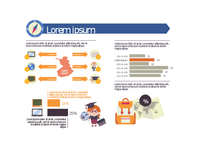
This education infographic template consists of design elements: callouts, world map contour, horizontal bar chart indicator, horizontal bar graph, pictograms.
Simply add text and data to design your educational infogram.
The template "Education infogram 2" for the ConceptDraw PRO diagramming and vector drawing software is included in the Education Infographics solition from the area "Business Infographics" in ConceptDraw Solution Park.
Educational infogram template
Educational infogram template, world map, two bars horizontal bar chart indicator, teacher, schoolmarm, teacher pointer, teacher, school satchel, schoolbag, school bag, portfolio, school backpack, schoolbag, school bag, open book, laptop computer, horizontal bar chart, green blackboard, school board, teacher pointer, chalk, sponge, graduation cap, square academic cap, master's cap, globe, education diagram, earth, diploma, compass, circle callout, callout with divider, arrow text block, arrow right callout, arrow left callout, Finland,

Map of Continents

A continent is one of several very large landmasses on Earth. ConceptDraw DIAGRAM diagramming and vector drawing software offers the unique Continent Maps Solution from the Maps Area which is indispensable for drawing the map of continents of the Earth.
HelpDesk

How to Draw a Map of North America

Geographic maps, cardiograms, and thematic maps are often used for geographical visualization of business information. Any country can inspire a wealth of geopolitical statistical data. A common way of assimilating this data is to create maps that convey a particular theme or subject matter in relation to a specific geographical area. Known as thematic maps, they cover themes such as population density, average rainfall, or political allegiance, differentiating the data by using graphical elements and annotation. Thematic maps contrast general reference maps, which tend to display information on a variety of subjects — vegetation, topology, roads, and highways, for example. A thematic map will always focus on one particular subject matter. ConceptDraw DIAGRAM can be helpful as a tool for creating maps of countries and regions of the world. It allows you to draw continental maps quickly and easily using the special templates and vector stencils libraries.

Map of USA

It is impossible to imagine modern life and science without maps, they surround us anywhere, they are used in geography, history, politics, economics, and many other fields of science. ConceptDraw DIAGRAM diagramming and vector drawing software offers the USA Maps Solution from the Maps Area of ConceptDraw Solution Park with its collection of samples and libraries for easy drawing the Map of USA.

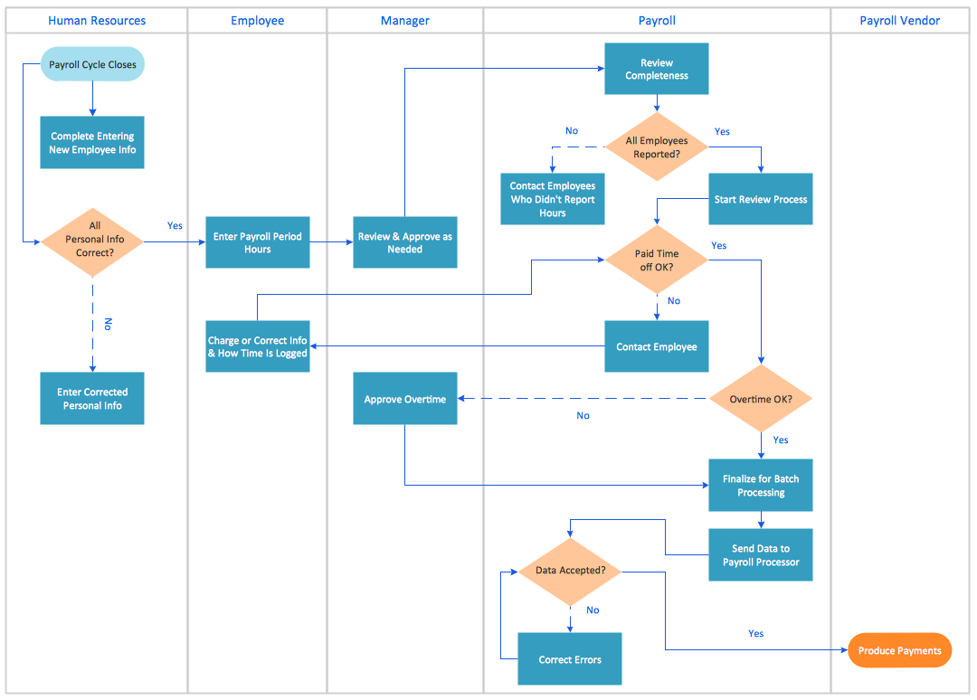
Cross-Functional Process Map Template

When you need a drawing software to create a professional looking cross-functional charts, ConceptDraw with its Arrows10 Technology - is more than enough versatility to draw any type of diagram with any degree of complexity. Use templates with process maps, diagrams, charts to get the drawing in minutes.