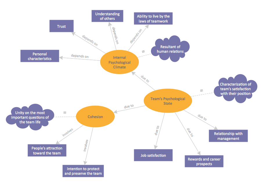
Concept Map
Geo Map — Asia

 UK Map
The Map of UK solution contains collection of professionally designed samples and scalable vector stencil graphics maps, representing the United Kingdom counties, regions and cities. Use the Map of UK solution from ConceptDraw Solution Park as the base fo
 Germany Map
The Germany Map solution contains collection of samples, templates and scalable vector stencil graphic maps, representing map of Germany and all 16 states of Germany. Use the Germany Map solution from ConceptDraw Solution Park as the base for various them
 USA Maps
Use the USA Maps solution to create a map of USA, a US interstate map, printable US maps, US maps with cities and US maps with capitals. Create a complete USA states map.
 HR Dashboard
The HR Dashboard solution extends ConceptDraw DIAGRAM functionality with powerful drawing tools and great collection of comprehensive vector design elements, icons, pictograms and objects, navigation elements, live objects of HR charts, HR indicators, and thematic maps. The range of HR Dashboards applications is extensive, among them the human resource management, recruitment, hiring process, human resource development. ConceptDraw DIAGRAM software is perfect for creation HR Dashboard with any goal you need. It gives you all opportunities for designing not only informative, but also professional looking and attractive HR Dashboards of any style and degree of detalization, that are perfect for using in presentations, reports and other thematic documents.
Geo Map - Africa - Nigeria
Superb Examples of Infographic Maps
Geo Map - Europe - United Kingdom

 Spatial Dashboard
Spatial dashboard solution extends ConceptDraw DIAGRAM software with templates, samples and vector stencils libraries with thematic maps for drawing visual dashboards showing spatial data.
- Concept Maps And Thematic Web Charts
- Concept Map | UK Map | Continent Maps | Difference Between ...
- Thematic Web Chart
- Concept Map | Simple Diagramming | Value Stream Mapping | Draw ...
- Concept Mapping | Team psychological characteristics - Concept ...
- How to Draw a Mind Map on PC Using ConceptDraw MINDMAP ...
- Internet marketing - Concept map | Design elements - Marketing ...
- Concept Maps | Bubble Diagrams | Geo Map — Asia | Diagram Of ...
- Concept Maps | Cafe and Restaurant Floor Plans | The Best Choice ...
- Online shop - Concept map | Concept Maps | How to Share Mind ...