 Australia Map
To simplify the work of drawing the maps of Australia in the ConceptDraw DIAGRAM application, the Australia Map solution can be used, including its collection of scalable graphics that is known to be representing the political geography of Australia, splitting into distinct state maps. Each of the available maps offers many details that can be added to the maps so it becomes possible to show this country’s sub-divisions and its local government areas. Being focused on the main cities and the capital, the maps of Australia can be created by edited the pre-made templates.
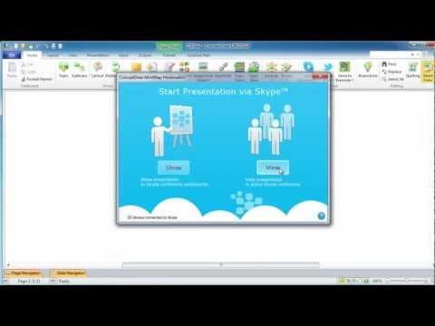
Online Collaboration via Skype

 Site Plans
The Site Plans solution extends ConceptDraw DIAGRAM with samples, templates and numerous libraries of design elements making it powerful site plan software, ideal for landscape drawing, designing Site Plans, Site Layout Plans, Landscape Design Drawings, Home Site Plans, Hotel Site Plans, Park Site Plans, for developing the residential and commercial landscape design drawings and site plan, parks planning, landscaping territories, lighting trails, for creating drainage facilities, yard layouts, plant maps, outdoor recreational facilities, and irrigation systems plans.
 Business Process Mapping
The Business Process Mapping solution has a collection of vector graphic libraries, pre-made templates, and examples of the business process maps. They are useful for many business specialists including economists, politicians, analysts, and other economic experts, officials and state managers for making the unique and professionally looking drawings. Use it to create an effective Business process map, SIPOC diagram, Swim lanes flowchart and clearly define the necessary business processes due to their inputs and outputs.
 Directional Maps
Directional Maps solution extends ConceptDraw DIAGRAM software with templates, samples and libraries of vector stencils for drawing the directional, location, site, transit, road and route maps, plans and schemes.
Geo Map - World

Geo Map — Australia

Geo Map Software

Geo Map - Australia - Nothern Territory

Create Graphs and Charts

Value Stream Mapping for the Lean Office

 Business Diagrams
The Business Diagrams Solution extends ConceptDraw DIAGRAM with an extensive collection of professionally designed illustrative samples and a wide variety of vector stencils libraries, which are the real help for all business-related people, business analysts, business managers, business advisers, marketing experts, PR managers, knowledge workers, scientists, and other stakeholders allowing them to design the bright, neat, expressive and attractive Bubble Diagrams, Circle-Spoke Diagrams, Circular Arrows Diagrams, and Venn Diagrams with different quantity of sets in just minutes; and then successfully use them in documents, reports, statistical summaries, and presentations of any style.
Geo Map - Europe - Bulgaria

Maps and Directions

Infographic Software

 Sport Field Plans
Sport Field Plans solution extends ConceptDraw DIAGRAM with samples, templates and libraries of ready-made design elements for developing layouts of sport fields, recreation areas, playground layouts plans, and for professional drawing various sport field plans — for football, basketball, volleyball, golf, baseball, tennis, etc. Depict all your playground layout ideas easily and decisively implement the playground layout designs. Use the final colorful, strict and accurate ConceptDraw's playground layouts when designing the building documentation, brochures, booklets, advertising materials, sports editions, sport maps, business plans, on web sites of sport complexes, sport centers, hotels, etc.
Geo Map — Europe — France

 Floor Plans
Construction, repair and remodeling of the home, flat, office, or any other building or premise begins with the development of detailed building plan and floor plans. Correct and quick visualization of the building ideas is important for further construction of any building. Floor Plans solution extends the ConceptDraw DIAGRAM with built-in drawing tools and assists in constructing all the needed Building Plans, Floor Plans, Architectural sketches and Architectural plans, Projects of the high-rise buildings and landscapes.
 Manufacturing and Maintenance
Manufacturing and maintenance solution extends ConceptDraw DIAGRAM software with illustration samples, templates and vector stencils libraries with clip art of packaging systems, industrial vehicles, tools, resources and energy.
- Sales Dashboard - Australia | Free Territory Sales Map Software
- Geo Map - Australia | Map Software To Buy For Sales Territory
- Geo Map - Australia - Nothern Territory | Geo Map - Canada ...
- Territory Mapping Software Free Australia
- Geo Map - Canada - Northwest Territories | Geo Map - Australia ...
- Australia Map | Competitor Analysis | Creating Sales Territory Map
- Geo Map - Australia - Nothern Territory | Continent Maps | Geo Map ...
- Sales Process Map | Best Flowcharts | Free Sales Mapping Software
- Marketing and Sales Organization chart. Organization chart ...
- Stakeholder Mapping Tool | Territory Map Maker Free