The vector stencils library "Marketing maps" contains 44 state map contours with capitals and major cities: the Group of Twenty (G20) state maps, EU state maps and World map.
Use it to visualize geospatial information in your marketing infograms.
"The Group of Twenty (also known as the G-20 or G20) is a forum for the governments and central bank governors from 20 major economies. The members, shown highlighted on the map at right, include 19 individual countries—Argentina, Australia, Brazil, Canada, China, France, Germany, India, Indonesia, Italy, Japan, Republic of Korea, Mexico, Russian Federation, Saudi Arabia, South Africa, Turkey, United Kingdom, United States—and the European Union (EU). The EU is represented by the European Commission and by the ECB." [G-20 major economies. Wikipedia]
The G-20 state map contours example "Design elements - Marketing maps (G-20)" was created using the ConceptDraw PRO diagramming and vector drawing software extended with the Marketing Infographics solition from the area "Business Infographics" in ConceptDraw Solution Park.
The Group of Twenty (G-20) state maps
-state-maps-design-elements---marketing-maps-(g-20).png--diagram-flowchart-example.png)
Geo Map - Africa

Geo Map - Africa - Cameroon

Geo Map - Canada - Saskatchewan

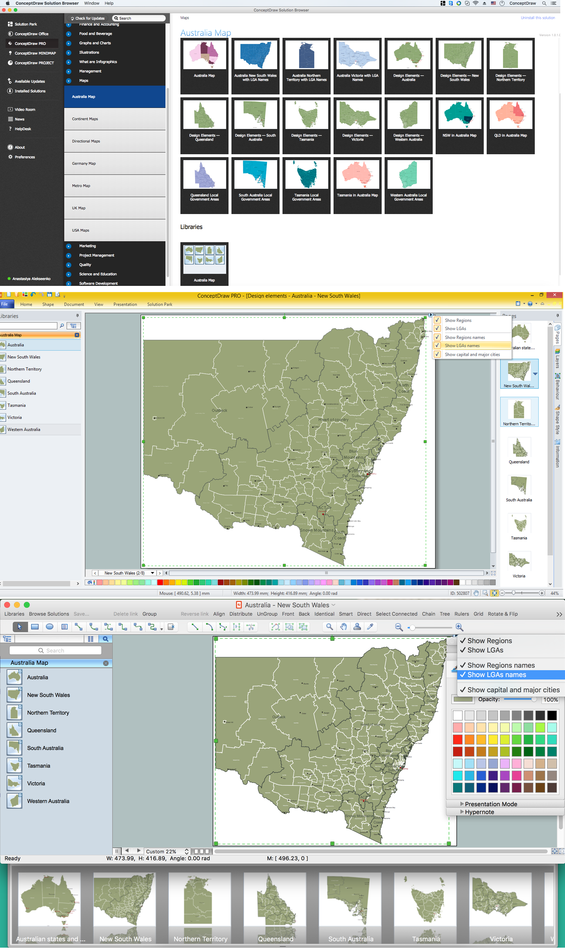
Australia Map — New South Wales
Use this Africa map template to design your political or thematic map.
This Africa map template for the ConceptDraw PRO diagramming and vector drawing software is included in the Continent Maps solution from the Maps area of ConceptDraw Solution Park.
This Africa map template for the ConceptDraw PRO diagramming and vector drawing software is included in the Continent Maps solution from the Maps area of ConceptDraw Solution Park.
Africa map

Geo Map — United States of America Map

Geo Map - Europe - Bosnia and Herzegovina
Geo Map — Europe — Germany

Geo Map - Europe - Belarus
 Maps
Maps
This solution extends ConceptDraw DIAGRAM.4 with the specific tools necessary to help you draw continental, directional, road, or transit maps, to represent international, business, or professional information visually.
Geo Map - Asia - Philippines

Geo Map — USA — Florida

Geo Map - USA - Nevada

Geo Map - Europe - Switzerland

- Africa map with countries, main cities and capitals - Template ...
- Africa map with countries, main cities and capitals - Template | Geo ...
- Africa map with countries, main cities and capitals - Template | Geo ...
- Africa map with countries, main cities and capitals - Template | Geo ...
- Geo Map - South America Continent | Design elements - Marketing ...
- Africa map with countries, main cities and capitals - Template | Africa ...
- Africa map with countries, main cities and capitals - Template | Maps ...
- Africa map with countries, main cities and capitals - Template | Geo ...
- Africa map with countries, main cities and capitals - Template | Geo ...
- Africa map with countries, main cities and capitals - Template | South ...
- Africa map - Template | Africa map with countries, main cities and ...
- Europe map with capitals - Template | Geo Map - Europe - France ...
- Geo Map - Europe | Geo Map - South America Continent | Geo Map ...
- Geo Map - United States of America Map | North America map with ...
- Geo Map - Asia - India | Design elements - Marketing maps (G-20 ...
- Geo Map - Africa
- Australia Map Big Cities
- Australia Map — States and Cities | Geo Map - Europe - Russia ...
- Canada Usa Russia Map
- Map Of East Germany With Cities