How to draw Metro Map style infographics? (New York)

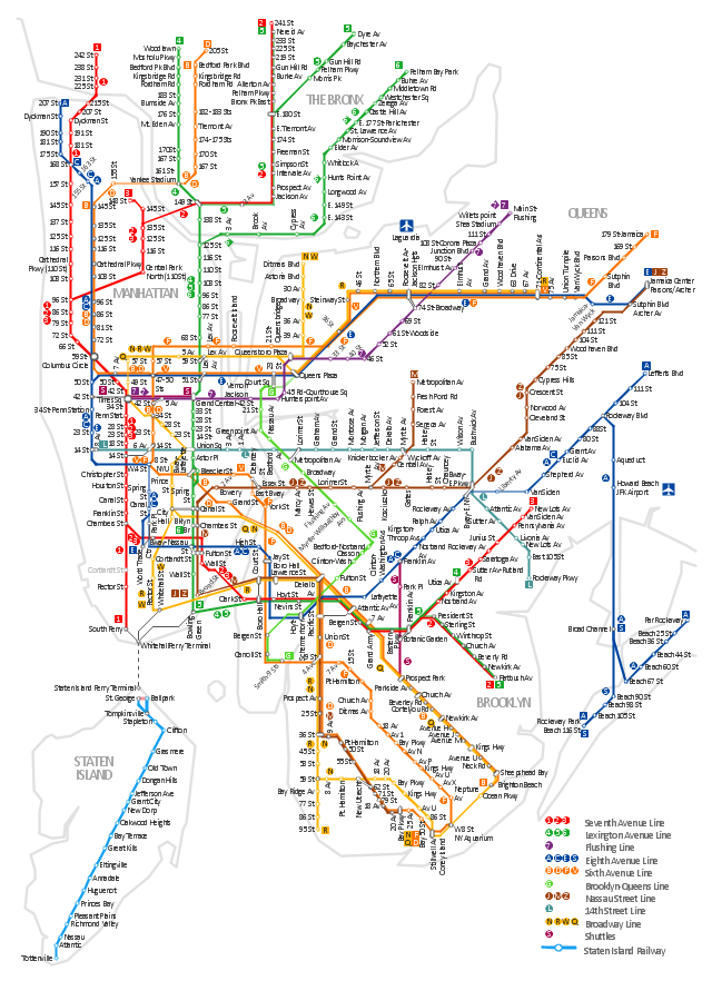
New York Subway has a long history starting on October 27, 1904. Since the opening many agencies have provided schemes of the subway system. At present time are 34 lines in use. This page present New York City subway map construct with Metro Map Solution in Conceptdraw PRO software. This is a one-click tool to add stations to the map. It lets you control the direction in which you create new stations, change lengths, and add text labels and icons. It contains Lines, Stations, and Landmarks objects
"The New York City Subway is a rapid transit system owned by the City of New York and leased to the New York City Transit Authority, a subsidiary agency of the Metropolitan Transportation Authority. It is the most extensive public transportation system in the world by number of stations, with 468 stations in operation (421, if stations connected by transfers are counted as single stations). The New York City Subway is also one of the world's oldest public transit systems. Overall, the system contains 209 mi (337 km) of routes, translating into 656 miles (1,056 km) of revenue track; and a total of 842 miles (1,355 km) including non-revenue trackage." [New York City Subway. Wikipedia]
The transit map example "New York City Subway map" was created using the ConceptDraw PRO diagramming and vector drawing software extended with the Metro Map solution from the Maps area of ConceptDraw Solution Park.
The transit map example "New York City Subway map" was created using the ConceptDraw PRO diagramming and vector drawing software extended with the Metro Map solution from the Maps area of ConceptDraw Solution Park.
New York City Subway
How to draw Metro Map style infographics? Moscow, New York, Los Angeles, London

 Metro Map
Metro Map solution extends ConceptDraw PRO software with templates, samples and library of vector stencils for drawing the metro maps, route maps, bus and other transport schemes, or design tube-style infographics.
- Infographic design elements, software tools Subway and Metro style ...
- How to draw Metro Map style infographics? Moscow, New York , Los
- Infographic software: the sample of New York City Subway map ...
- How to draw Metro Map style infographics? ( New York ) | Infographic ...
- Metro Map | How to draw Metro Map style infographics? Moscow ...
- How to draw Metro Map style infographics? Moscow, New York , Los ...
- Metro Map | How to draw Metro Map style infographics? ( New York ...
- How to draw Metro Map style infographics? ( New York ) | How to ...
- How to draw Metro Map style infographics? ( New York ) | How to ...
- How to draw Metro Map style infographics? Moscow, New York , Los ...
- How to draw Metro Map style infographics? ( New York ) | How to ...
- How to draw Metro Map style infographics? (London) | How to draw ...
- Metro Map | Best Value Stream Mapping mac Software | Subway ...
- Infographic design elements, software tools Subway and Metro style ...
- How to draw Metro Map style infographics? Moscow, New York , Los ...
- Infographic design elements, software tools Subway and Metro style ...
- How to draw Metro Map style infographics? Moscow, New York , Los ...
- Metro Map | Maps | How to draw Metro Map style infographics ...
- Metro Map | How to draw Metro Map style infographics? Moscow ...
- How to draw Metro Map style infographics? Moscow, New York , Los ...