Geo Map — United States of America Map

"A state of the United States of America is one of the 50 constituent political entities that shares its sovereignty with the United States federal government."
[U.S. state. Wikipedia]
This political map example was redesigned from the Wikimedia Commons file: Map of USA with state names 2.svg.
[commons.wikimedia.org/ wiki/ File:Map_ of_ USA_ with_ state_ names_ 2.svg]
This file is licensed under the Creative Commons Attribution-Share Alike 3.0 Unported license. [creativecommons.org/ licenses/ by-sa/ 3.0/ deed.en]
The example "Map of USA with state names" was created using the ConceptDraw PRO diagramming and vector drawing software extended with the Continent Map solution from the Maps area of ConceptDraw Solution Park.
Political map - USA

Map of Australia

Map Australia

 Continent Maps
Continent Maps solution extends ConceptDraw PRO software with templates, samples and libraries of vector stencils for drawing the thematic maps of continents, state maps of USA and Australia.
USA Maps

Map of USA States

UK Map

 Australia Map
For graphic artists creating accurate maps of Australia. The Australia Map solution - allows designers to map Australia for their needs, offers a collection of scalable graphics representing the political geography of Australia, split into distinct state
Map of Germany — Schleswig-Holstein State

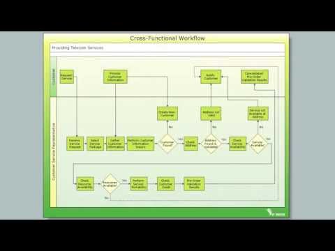
Cross-Functional Flowchart

USA Map

 USA Maps
Use the USA Maps solution to create a map of USA, a US interstate map, printable US maps, US maps with cities and US maps with capitals. Create a complete USA states map.
Concept Maps

Geo Map - Africa - Morocco

- Geo Map - Africa - Senegal | Asia Map No Names
- Geo Map - Asia - Vietnam | Central Asia - Political map | Continent ...
- Map Of United States With State Names
- Maps Continent The Names
- Concept Maps | Water Transport Images With Names
- North America Map Hindi Country Names
- Map of USA with state names
- Map of USA with state names | Benefit Corporation legislation ...
- Geo Map - United States of America Map | Map of USA | Geo Map ...
- Geo Map - USA - Mexico | Map of USA with state names | Geo Map ...
- Concept Maps | Name Water Transport Vehicles
- American Continent With Names
- Physics Sign Names
- Map Of America With Names
- Map of USA with state names | Geo Map - USA - Wisconsin | Geo ...
- Us Map With States Names
- Cross-Functional Flowchart | Concept Maps | Names Of Water ...
- Geo Map - United States of America Map | Map of USA with state ...
- Diagram Of Maps And Country Names
- Us Map With States Names Template