 USA Maps
The USA Maps solution can be used as an additional tool to the ConceptDraw DIAGRAM diagramming and drawing software. Each of the pre-made maps that are available to be taken from this solution is scaled. The USA Maps solution allows using the option of adding further details such as country’s borders, states’ names, their capitals and major cities that can be either shown or hidden by using the action menu for each of the state maps. The solution is incredibly useful for all who have an international business working with people, providing other countries products from the USA, or making purchases to supply those who live in the US with.
USA Map

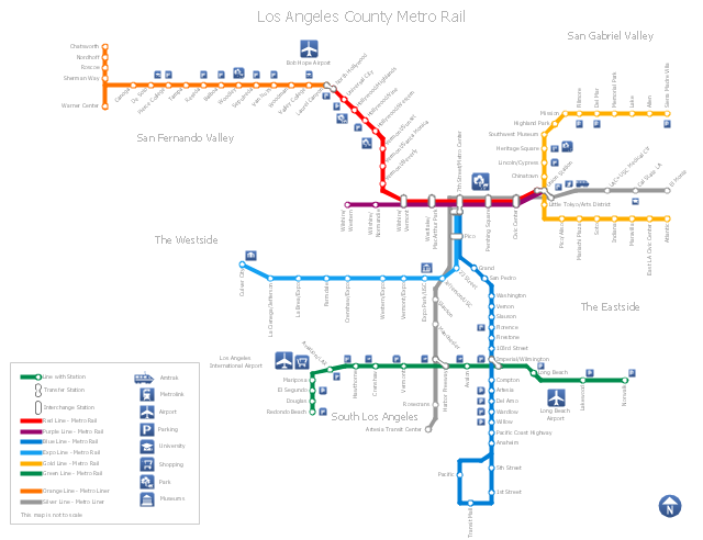
"Metro Rail is an urban rail system serving Los Angeles County, California. It consists of six lines, including two rapid transit subway lines (the Red and Purple Lines) and four light rail lines (the Blue, Green, Gold and Expo lines) serving 80 stations. It connects with the Metro Liner bus rapid transit system (the Orange Line and Silver Line) and also with the Metrolink commuter rail systems. The system, which has an average daily weekday ridership of 362,904 as of June 2012, is owned and operated by the Los Angeles County Metropolitan Transportation Authority (Metro) and started service in 1990. It has been extended significantly since that time and several further extensions are either in the works or being considered.
It is the indirect descendant of the Pacific Electric Red Car and Los Angeles Railway Yellow Car lines, which operated between the late 19th century and the 1960s." [Metro Rail (Los Angeles County). Wikipedia]
The transit map example "Los Angeles county Metro Rail map" was created using the ConceptDraw PRO diagramming and vector drawing software extended with the Metro Map solution from the Maps area of ConceptDraw Solution Park.
Los Angeles metro map
Map of USA States

Geo Map — USA — Virginia

USA Maps

Map of UK — Wales Counties and Towns

Geo Map — USA — Massachusetts

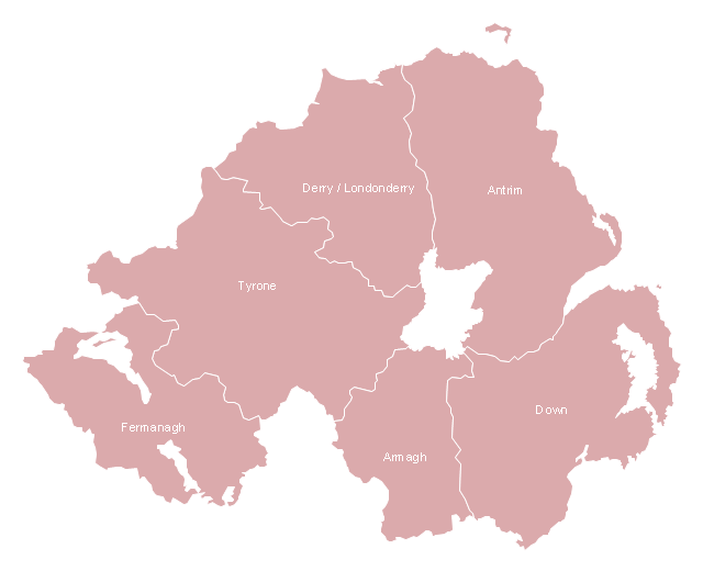
This map example shows Northern Ireland counties borders. You can also show cities and towns by using Action menu command.
"The counties of Northern Ireland were the principal local government divisions of Northern Ireland from its creation in 1921 until 1972, when their governmental features were abolished and replaced with twenty-six unitary authorities.
In total Northern Ireland consisted of six counties: Antrim, Armagh, Down, Fermanagh, Londonderry and Tyrone. These form two-thirds of the historical province of Ulster." [Counties of Northern Ireland. Wikipedia]
The map example "Northern Ireland counties map" was drawn using ConceptDraw PRO software extended with the Map of UK solution from the Maps area of ConceptDraw Solution Park.
Northern Ireland ciities and towns map
Map of UK — England Regions and counties

Map of UK — Cornwall

ConceptDraw Arrows10 Technology

Geo Map — USA — Nevada

USA Map States

Geo Map — USA — Tennesse

Geo Map — USA — Ohio

Geo Map — USA — New Hampshire

 UK Map
Making a map of the UK can be as simple as to create any other needed drawing by using the pre-made examples and templates from the Map of UK solution. The last-mentioned application may increase the opportunities for all users of the ConceptDraw DIAGRAM charting and drawing software by providing the collection of the professionally designed samples and vector stencil graphics of the maps which represent the United Kingdom counties, cities, and regions. The Map of UK solution can be used while working in the ConceptDraw DIAGRAM application enabling its users to have the pre-made templates as the base for some other, unique-looking UK maps of many different levels of detail. It is useful for visualizing business and other UK-related thematic information mentioning the UK geographic areas for either reference guides, presentations or other purposes.
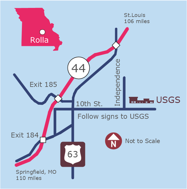
This example was created on the base of the locator map from the website of the Rolla USGS Center. "Rolla USGS Center.
The Rolla USGS is home to the National Geospatial Technical Operations Center, the Missouri Water Science Center, the National Spatial Data Infrastructure Partnership Office Liaisons, and the Rolla Science Information Services office. Employees at this location provide customers with geospatial, geographic, water, biologic and geologic products; science; data; and research, along with offering partnerships and contracting opportunities for local, state, federal, and private entities.
The National Geospatial Technical Operations Center (NGTOC) is a production, research, and data management facility for maps and digital cartographic data products. The work of the NGTOC supports planning and development activities; construction projects; scientific studies; resource management; and environmental monitoring activities, nationwide, at every level of government, academia, and the private sector. The NGTOC in Rolla, along with the other NGTOC site in Denver, plays a key operational role in supporting The National Map, US Topo, The National Atlas™ and all associated products and services, including national coverage of digital orthoimagery, digital elevation data, the National Hydrography Dataset, geographic names, public domain transportation, structures, and governmental units data, and topographic maps. Staff in the Center of Excellence for Geospatial Information Science (CEGIS) are also located in the NGTOC. ... Rolla Missouri Location Map The Rolla USGS Center is located in Rolla, Missouri. Rolla, the county seat of Phelps County, is an attractive mixture of rural and urban life. It is the home of several high-technology businesses and Federal agencies, including the U.S. Geological Survey and the U.S. Forest Service. Missouri University of Science and Technology, a nationally recognized leader in science and technology, has educated students in Rolla for more than 140 years.
Rolla is located at the crossroads of I-44, US 63 and Missouri Highway 72 and is a popular stop on Historic Route 66. Jefferson City, the state capital, is 62 miles to the north, St. Louis lies 106 miles northeast and Springfield is 110 miles southwest." [mcmcweb.er.usgs.gov]
The example "Rolla USGS Center locator map" was created using the ConceptDraw PRO diagramming and vector drawing software extended with the Directional Maps solution from the Maps area of ConceptDraw Solution Park.
Locator map
- USA Map | UK Map | Map of USA States | County Map Software
- Los Angeles county Metro Rail map | How to draw Metro Map style ...
- Map of UK — England Regions and counties | Map of UK — Wales ...
- Los Angeles county Metro Rail map | Geo Map - New York | USA Maps
- Geo Map — United States of America Map | USA Maps | Geo Map ...
- Los Angeles county Metro Rail map | How to draw Metro Map style ...
- MTA Subway Map | Metro Maps | Metro Map | Mta Subway Map Vector
- Geo Map — South America Continent - USA | Flags Of Many County
- Los Angeles county Metro Rail map | How to draw Metro Map style ...