 Directional Maps
Directional Maps solution extends ConceptDraw PRO software with templates, samples and libraries of vector stencils for drawing the directional, location, site, transit, road and route maps, plans and schemes.
 Maps Area
Solutions from the Maps Area of ConceptDraw Solution Park collect templates, samples and libraries of vector stencils for drawing geographical, directional and transport maps.
 Vehicular Networking
The Vehicular Networking solution extends the ConceptDraw PRO software functionality with specialized tools, wide variety of pre-made vector objects, collection of samples and templates in order to help network engineers design vehicular network diagrams for effective network engineering activity, visualize vehicular networks, develop smart transportation systems, design various types of vehicle network management diagrams, regional network diagrams, vehicular communication system diagrams, vehicular ad-hoc networks, vehicular delay-tolerant networks, and other network engineering schemes.
The vector stencils library "Transport map" contains 96 signs and pictograms for drawing road and transit maps.
"A transit map is a topological map in the form of a schematic diagram used to illustrate the routes and stations within a public transport system - whether this be bus lines, tramways, rapid transit, commuter rail or ferry routes. The main components are color coded lines to indicate each line or service, with named icons to indicate stations or stops.
Transit maps can be found in the transit vehicles, at the platforms or in printed timetables. Their primary function is to help users to efficiently use the public transport system, including which stations function as interchange between lines. Unlike conventional maps, transit maps are usually not geographically accurate - instead they use straight lines and fixed angles, and often illustrate a fixed distance between stations, compressing those in the outer area of the system and expanding those close to the center." [Transit map. Wikipedia]
The pictograms example "Design elements - Transport map" was created using the ConceptDraw PRO diagramming and vector drawing software extended with the Spatial Infographics solution from the Maps area of ConceptDraw Solution Park.
Transport map pictograms

 Maps
Maps
This solution extends ConceptDraw PRO v9.4 with the specific tools necessary to help you draw continental, directional, road, or transit maps, to represent international, business, or professional information visually.
 Plant Layout Plans
This solution extends ConceptDraw PRO v.9.5 plant layout software (or later) with process plant layout and piping design samples, templates and libraries of vector stencils for drawing Plant Layout plans. Use it to develop plant layouts, power plant desig
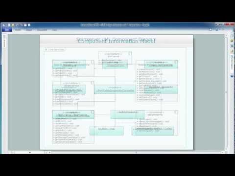
UML Composite Structure Diagram

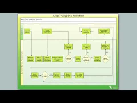
Cross-Functional Flowchart

 Aerospace and Transport
This solution extends ConceptDraw PRO software with templates, samples and library of vector clipart for drawing the Aerospace and Transport Illustrations. It contains clipart of aerospace objects and transportation vehicles, office buildings and anci
 Universal Diagramming Area
This area collects solutions for drawing diagrams, charts, graphs, matrices, geographic and road maps for education, science, engineering, business.
 Illustration Area
Solutions from the Illustrations Area of ConceptDraw Solution Park collect templates, samples and libraries of color scalable vector stencils, icons and clip art for illustrating documents, presentations, infographics, web sites and blogs.
UK Map

Business diagrams & Org Charts with ConceptDraw PRO

Aerospace - Design Elements

Pyramid Charts

- Diagram Of Roundabout In Traffic Road Sign
- Design elements - Road signs | Road signs - Vector stencils library ...
- Directional Maps | Road signs - Vector stencils library | Sign Making ...
- Visible light communication | Road signs - Vector stencils library ...
- Inter-vehicle communication systems | Road signs - Vector stencils ...
- Drawing Of Traffic Symbols
- Road signs - Vector stencils library | Directional Maps | Maps Area ...
- 3D pictorial street map | Design elements - 3D directional maps ...
- Diagrams Of Road Signs
- Road signs - Vector stencils library | Directional Maps | Maps and ...
- Road signs - Vector stencils library | Directional Maps | Map ...
- Design elements - Road signs | Road signs - Vector stencils library ...
- Road signs - Vector stencils library | Recreation signs - Vector ...
- Road Signs Taxi
- Fire Exit Plan. Building Plan Examples | Emergency Plan | Road ...
- Road signs - Vector stencils library | Software workflow diagram ...
- Road signs - Vector stencils library | Design elements - Recreation ...
- Road signs
- Diagrams Of Traffic Signs
- Samples Of Traffic Signs