This site uses cookies. By continuing to browse the ConceptDraw site you are agreeing to our Use of Site Cookies.
The vector stencils library "British Isles" contains 4 map contours: British Isles, Great Britain, Isle of Man, Channel Islands.
Use it to design your thematic and political maps with ConceptDraw PRO software.
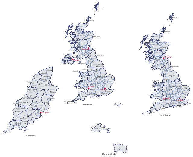
"The British Isles are a group of islands off the north-western coast of continental Europe that consist of the islands of Great Britain, Ireland and over six thousand smaller isles. Two sovereign states are located on the islands: Ireland (a republic which covers roughly five-sixths of the island with the same name) and the United Kingdom of Great Britain and Northern Ireland (which includes the countries of England, Scotland, Wales and Northern Ireland). The British Isles also include three dependencies of the British Crown: the Isle of Man and, by tradition, the Bailiwick of Jersey and the Bailiwick of Guernsey in the Channel Islands, although the latter are not physically a part of the archipelago." [British Isles. Wikipedia]
The thematic map templates example "Design elements - British Islesl" is included in the Map of UK solution from the Maps area of ConceptDraw Solution Park.
Map contours with cities and towns
Map contours with cities and towns, Yorkshire, Worcestershire, Wiltshire, Wigtownshire, Westmorland, West Lothian, Warwickshire, Wales, Tyrone, Sutherland, Sussex, Surrey, Suffolk, Stirlingshire, Staffordshire, Somerset, Shropshire, Shetland, Selkirkshire, Scotland, Rutland, Roxburghshire, Ross-shire, Renfrewshire, Radnorshire, Perthshire, Pembrokeshire, Peeblesshire, Oxfordshire, Orkney, Nottinghamshire, Nothern Ireland, Northumberland, Northamptonshire, Norfolk, Nairnshire, Moray, Montgomeryshire, Monmouthshire, Midlothian, Middlesex, Merionethshire, Londonderry, Lincolnshire, Leicestershire, Lancashire, Lanarkshire, Kirkcudbrightshire, Kinross-shire, Kincardineshire, Kent, Isle of Wight, Isle of Man, Inverness-shire, Huntingdonshire, Hertfordshire, Herefordshire, Hampshire, Great Britain, Gloucestershire, Glamorgan, Flintshire, Fife, Fermanagh, Essex, England, East Lothian, Durham, Dunbartonshire, Dumfriesshire, Down, Dorset, Devon, Derbyshire, Denbighshire, Cumberland, Cromartyshire, Cornwall, Clackmannanshire, Cheshire, Channel Islands, Carmarthenshire, Cardiganshire, Cambridgeshire, Caithness, Caernarfonshire, Buckinghamshire, British Isles, Brecknockshire, Berwickshire, Berkshire, Bedfordshire, Banffshire, Ayrshire, Armagh, Argyllshire, Antrim, Angus, Anglesey, Aberdeenshire,
Used Solutions

Map of UK

The United Kingdom of Great Britain and Northern Ireland, commonly known as the United Kingdom (UK) or Britain, is a sovereign state in Europe.
How to design the Map of UK fast and easy? It is incredibly convenient to use special software. ConceptDraw PRO diagramming and vector drawing software offers the Map of UK Solution from the Maps Area of ConceptDraw Solution Park specially developed to make easier drawing the maps of UK counties, various UK related thematic maps and cartograms on their base.
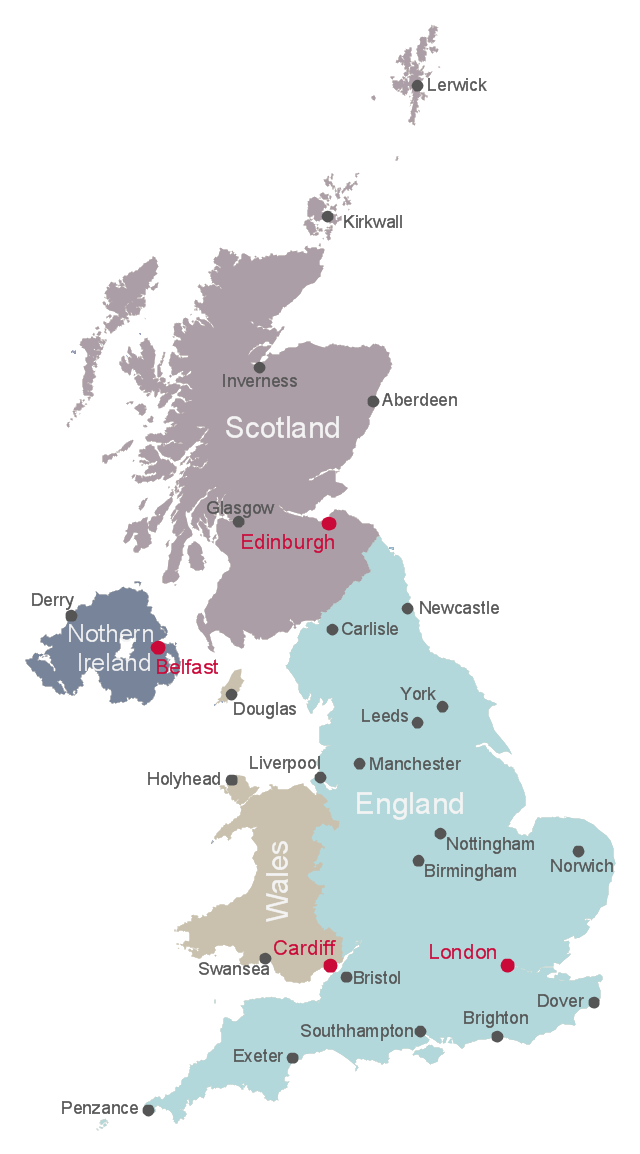
This map example shows UK countries borders and cities. You can also show counties borders using Action menu command.
"The United Kingdom (UK) comprises four countries: England, Scotland, Wales and Northern Ireland.
Within the United Kingdom, a unitary sovereign state, Northern Ireland, Scotland and Wales have gained a degree of autonomy through the process of devolution. The UK Parliament and British Government deal with all reserved matters for Northern Ireland and Scotland and all non-transferred matters for Wales, but not in general matters that have been devolved to the Northern Ireland Assembly, Scottish Parliament and National Assembly for Wales. Additionally, devolution in Northern Ireland is conditional on co-operation between the Northern Ireland Executive and the Government of Ireland and the British Government consults with the Government of Ireland to reach agreement on some non-devolved matters for Northern Ireland." [Countries of the United Kingdom. Wikipedia]
The example "Map of the British Isles" was drawn using ConceptDraw PRO software extended with the Map of UK solution from the Maps area of ConceptDraw Solution Park.
United Kingdom countries map
United Kingdom countries map, Yorkshire, Worcestershire, Wiltshire, Wigtownshire, Westmorland, West Lothian, Warwickshire, Tyrone, Sutherland, Sussex, Surrey, Suffolk, Stirlingshire, Staffordshire, Somerset, Shropshire, Shetland, Selkirkshire, Scotland, Rutland, Roxburghshire, Ross-shire, Renfrewshire, Radnorshire, Perthshire, Pembrokeshire, Peeblesshire, Oxfordshire, Orkney, Nottinghamshire, Nothern Ireland, Northumberland, Northamptonshire, Norfolk, Nairnshire, Moray, Montgomeryshire, Monmouthshire, Midlothian, Middlesex, Merionethshire, Londonderry, Lincolnshire, Leicestershire, Lancashire, Lanarkshire, Kirkcudbrightshire, Kinross-shire, Kincardineshire, Kent, Isle of Wight, Isle of Man, Inverness-shire, Huntingdonshire, Hertfordshire, Hampshire, Gloucestershire, Glamorgan, Flintshire, Fife, Fermanagh, Essex, England, East Lothian, Durham, Dunbartonshire, Dumfriesshire, Down, Dorset, Devon, Derbyshire, Denbighshire, Cumberland, Cromartyshire, Cornwall, Clackmannanshire, Cheshire, Carmarthenshire, Cardiganshire, Cambridgeshire, Caithness, Caernarfonshire, Buckinghamshire, British Isles, Brecknockshire, Berwickshire, Berkshire, Bedfordshire, Banffshire, Ayrshire, Armagh, Argyllshire, Antrim, Angus, Anglesey, Aberdeenshire,
Used Solutions

map of england, map of scotland, united kingdom map, uk map, map of uk, great britain map, map of great britain, map of united kingdom, map of wales UK Map

map of england, map of scotland, united kingdom map, uk map, map of uk, great britain map, map of great britain, map of united kingdom, map of wales
The Map of UK solution contains collection of professionally designed samples and scalable vector stencil graphics maps, representing the United Kingdom counties, regions and cities. Use the Map of UK solution from ConceptDraw Solution Park as the base fo

Map of UK — Isle of Man

The Isle of Man, also known simply as Mann, is a self-governing Crown dependency in the Irish Sea between Great Britain and Ireland.
How to design the Map of UK fast and easy? It is incredibly convenient to use special software. ConceptDraw PRO diagramming and vector drawing software offers the Map of UK Solution from the Maps Area of ConceptDraw Solution Park specially developed to make easier drawing the maps of UK counties, various UK related thematic maps and cartograms on their base.

Map of UK — Great Britain Cities

Great Britain, also known as Britain, is an island in the North Atlantic off the north-west coast of continental Europe. With an area of 209,331 km2 (80,823 sq mi), it is the largest island in Europe and the ninth-largest in the world.
How to design the Map of UK fast and easy? It is incredibly convenient to use special software. ConceptDraw PRO diagramming and vector drawing software offers the Map of UK Solution from the Maps Area of ConceptDraw Solution Park specially developed to make easier drawing the maps of UK counties, various UK related thematic maps and cartograms on their base.

United Kingdom Map

The United Kingdom which includes England, Scotland, Wales, and Northern Ireland, is the 22nd-most populous country - important global city and financial centre. For administrative and political purposes, each country is divided into a number of counties, which are then subdivided into districts.
ConceptDraw PRO diagramming and vector drawing software offers the Map of UK Solution from the Maps Area of ConceptDraw Solution Park with large collection of predesigned samples and libraries with vector map objects for easy drawing the United Kingdom Map of any degree of detail.

Map of UK — England Regions and counties

England is a country that is part of the United Kingdom. It shares land borders with Scotland to the north and Wales to the west.
How to design the Map of UK fast and easy? It is incredibly convenient to use special software. ConceptDraw PRO diagramming and vector drawing software offers the Map of UK Solution from the Maps Area of ConceptDraw Solution Park specially developed to make easier drawing the maps of UK counties, various UK related thematic maps and cartograms on their base.

Map of UK — Cornwall

Cornwall is a county in England. Cornwall is a peninsula bordered to the north and west by the Celtic Sea, to the south by the English Channel, and to the east by the county of Devon, over the River Tamar.
How to design the Map of UK fast and easy? It is incredibly convenient to use special software. ConceptDraw PRO diagramming and vector drawing software offers the Map of UK Solution from the Maps Area of ConceptDraw Solution Park specially developed to make easier drawing the maps of UK counties, various UK related thematic maps and cartograms on their base.

Map of UK — Scotland

Scotland is a country that is part of the United Kingdom and covers the northern third of the island of Great Britain.
How to design the Map of UK fast and easy? It is incredibly convenient to use special software. ConceptDraw PRO diagramming and vector drawing software offers the Map of UK Solution from the Maps Area of ConceptDraw Solution Park specially developed to make easier drawing the maps of UK counties, various UK related thematic maps and cartograms on their base.

Map of Scotland

Scotland is a country that is part of the United Kingdom and covers the northern third of the island of Great Britain.
ConceptDraw PRO diagramming and vector drawing software extended with powerful Map of UK Solution from the Maps Area of ConceptDraw Solution Park is the best for drawing various kinds of United Kingdom maps, map of Scotland, map of England, map of Wales, Northern Ireland map, thematic UK maps of any detailing and geospatial infographics.

Map of UK — Northern Ireland

Northern Ireland is a constituent unit of the United Kingdom of Great Britain and Northern Ireland in the northeast of the island of Ireland. It is variously described as a country, province, region, or "part" of the United Kingdom, amongst other terms.
How to design the Map of UK fast and easy? It is incredibly convenient to use special software. ConceptDraw PRO diagramming and vector drawing software offers the Map of UK Solution from the Maps Area of ConceptDraw Solution Park specially developed to make easier drawing the maps of UK counties, various UK related thematic maps and cartograms on their base.

Map of UK — Wales Subdivisions and Towns

Wales is a country that is part of the United Kingdom and the island of Great Britain, bordered by England to its east, the Irish Sea to its north and west, and the Bristol Channel to its south.
How to design the Map of UK fast and easy? It is incredibly convenient to use special software. ConceptDraw PRO diagramming and vector drawing software offers the Map of UK Solution from the Maps Area of ConceptDraw Solution Park specially developed to make easier drawing the maps of UK counties, various UK related thematic maps and cartograms on their base.

Map of UK — Channel Islands

The Channel Islands are an archipelago in the English Channel, off the French coast of Normandy.
How to design the Map of UK fast and easy? It is incredibly convenient to use special software. ConceptDraw PRO diagramming and vector drawing software offers the Map of UK Solution from the Maps Area of ConceptDraw Solution Park specially developed to make easier drawing the maps of UK counties, various UK related thematic maps and cartograms on their base.

Map of UK — Wales Counties and Towns

Wales is a country that is part of the United Kingdom and the island of Great Britain, bordered by England to its east, the Irish Sea to its north and west, and the Bristol Channel to its south.
How to design the Map of UK fast and easy? It is incredibly convenient to use special software. ConceptDraw PRO diagramming and vector drawing software offers the Map of UK Solution from the Maps Area of ConceptDraw Solution Park specially developed to make easier drawing the maps of UK counties, various UK related thematic maps and cartograms on their base.