A map showing European membership of the EU and NATO.
"The European Union (EU) is an economic and political union of 28 member states that are located primarily in Europe.
The EU operates through a system of supranational independent institutions and intergovernmental negotiated decisions by the member states. Institutions of the EU include the European Commission, the Council of the European Union, the European Council, the Court of Justice of the European Union, the European Central Bank, the Court of Auditors, and the European Parliament. The European Parliament is elected every five years by EU citizens. The EU's de facto capital is Brussels." [European Union. Wikipedia]
"The principal military alliance in Europe remains NATO, which includes 21 of all EU member states as well as other non-EU European countries, Turkey, the United States and Canada." [Military of the European Union. Wikipedia]
"The North Atlantic Treaty Organization (NATO), also called the (North) Atlantic Alliance, is an intergovernmental military alliance based on the North Atlantic Treaty which was signed on 4 April 1949. The organization constitutes a system of collective defence whereby its member states agree to mutual defense in response to an attack by any external party. NATO's headquarters are in Brussels, Belgium, one of the 28 member states across North America and Europe, the newest of which, Albania and Croatia, joined in April 2009." [NATO. Wikipedia]
This Europe map example was redesigned using the ConceptDraw PRO diagramming and vector drawing software from the Wikimedia Commons file: EU and NATO.svg.
[commons.wikimedia.org/ wiki/ File:EU_ and_ NATO.svg]
The Europe political map example "European membership of the EU and NATO map" is included in the Continent Maps solution from the Maps area of ConceptDraw Solution Park.
Political map - EU and NATO

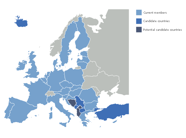
"The 2013 enlargement of the European Union saw Croatia join the European Union as their 28th member state on 1 July 2013.
Croatia is the second former Yugoslav republic to join the European Union after a decade-long negotiation process. The country applied for EU membership in 2003, and the European Commission recommended making it an official candidate in early 2004. Candidate country status was granted to Croatia by the European Council in mid-2004. The entry negotiations, while originally set for March 2005, began in October that year together with the screening process." [2013 enlargement of the European Union. Wikipedia]
This Europe map example was redesigned using ConceptDraw PRO diagramming and vector drawing software from the Wikimedia Commons file: EU28-candidate countries map.svg.
[commons.wikimedia.org/ wiki/ File:EU28-candidate_ countries_ map.svg]
The Europe political map example "EU 28: Candidate countries map" is included in the Continent Maps solution from the Maps area of ConceptDraw Solution Park.
Political map - European Union
The vector stencils library "Education maps" contains 44 state map contours with capitals and major cities: G-20 state maps, EU state maps and world map.
Use it to visualize geospatial information in your education infograms.
"The European Union (EU) is a politico-economic union of 28 member states that are primarily located in Europe: Austria, Belgium, Bulgaria, Croatia, Cyprus, Czech Republic, Denmark, Estonia, Finland, France, Germany, Greece, Hungary, Ireland, Italy, Latvia, Lithuania, Luxembourg, Malta, Netherlands, Poland, Portugal, Romania, Slovakia, Slovenia, Spain, Sweden, United Kingdom." [European Union. Wikipedia]
The European Union map contours example "Design elements - Education maps (EU)" was created using the ConceptDraw PRO diagramming and vector drawing software extended with the Education Infographics solition from the area "Business Infographics" in ConceptDraw Solution Park.
European Union state map contours
.png--diagram-flowchart-example.png)
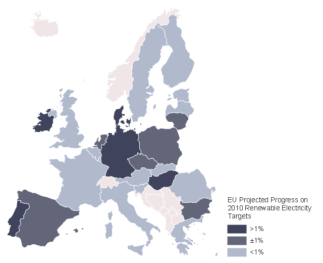
This example was created on the base of thematic map "2009 EU Renewable Electricity Share" from the article "European Union countries reach for higher renewable electricity generation" on the website of U.S. Energy Information Administration (EIA).
"Renewable generation includes hydropower, biomass, wind, solar, and geothermal. Nuclear power is not included." [www.eia.gov/ todayinenergy/ detail.cfm?id=2530]
"The countries of the European Union are the number two global leaders in the development and application of renewable energy. Promoting the use of renewable energy sources is important both to the reduction of the EU's dependence on foreign energy imports, and in meeting targets to combat global warming." [Renewable energy in the European Union. Wikipedia]
The thematic map example "EU countries map - Renewable electricity generation" was designed using the ConceptDraw PRO software extended with the Map of Germany solution from the Maps area of ConceptDraw Solution Park.
EU thematic map example
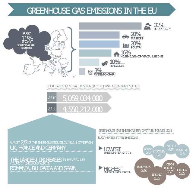
This ecology infographic example was created on the base of the infographics "Greenhouse gas emissions in the EU" from the Debating Europe website. [debatingeurope.eu/ wp-content/ uploads/ 2013/ 06/ TH_ 2_ social.png]
"A greenhouse gas (sometimes abbreviated GHG) is a gas in an atmosphere that absorbs and emits radiation within the thermal infrared range. This process is the fundamental cause of the greenhouse effect. The primary greenhouse gases in the Earth's atmosphere are water vapor, carbon dioxide, methane, nitrous oxide, and ozone. Greenhouse gases greatly affect the temperature of the Earth; without them, Earth's surface would average about 33 °C colder, which is about 59 °F below the present average of 14 °C (57 °F)." [Greenhouse gas. Wikipedia]
The ecology infographic example "EU greenhouse gas emissions" was created using the ConceptDraw PRO diagramming and vector drawing software extended with the Management Infographics solition from the area "Business Infographics" in ConceptDraw Solution Park.
Ecology infographics example
Used Solutions
This infographic template consist of Europe map contours, bar chart, title blocks, text blocks and callouts.
Use it to design your management infograms using the ConceptDraw PRO diagramming and vector drawing software.
The template "EU management infogram" is included in the Management infographics solution from the Business infographics area of ConceptDraw Solution Park.
Use it to design your management infograms using the ConceptDraw PRO diagramming and vector drawing software.
The template "EU management infogram" is included in the Management infographics solution from the Business infographics area of ConceptDraw Solution Park.
EU management infogram template
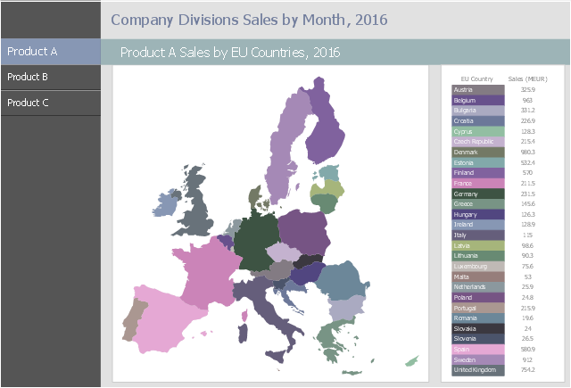
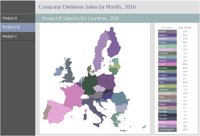
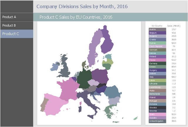
This business intelligence dashboard sample shows the three products sales by EU Countries in 2016 using thematic maps.
"A thematic map is a map that focuses on a specific theme or subject area. ... Thematic maps emphasize spatial variation of one or a small number of geographic distributions." [Thematic map. Wikipedia]
The BI dashboard example "Products A, B and C Sales by EU Countries, 2016" was created using ConceptDraw PRO software extended with the Business Intelligence Dashboards solution from the Business Processes area of ConceptDraw Solution Park.
Product A
Product B
Product C
Registered unemployment rate in Europe (EU-27) - september 2010. Data from Portal Euro-Indicators on EU Commission website (Eurostat). [epp.eurostat.ec.europa.eu/ portal/ page/ portal/ euroindicators/ peeis]
"Eurostat, the statistical office of the European Union, defines unemployed as those persons age 15 to 74 who are not working, have looked for work in the last four weeks, and ready to start work within two weeks, which conform to ILO standards. Both the actual count and rate of unemployment are reported. Statistical data are available by member state, for the European Union as a whole (EU27) as well as for the euro area (EA16). Eurostat also includes a long-term unemployment rate. This is defined as part of the unemployed who have been unemployed for an excess of 1 year.
The main source used is the European Union Labour Force Survey (EU-LFS). The EU-LFS collects data on all member states each quarter. For monthly calculations, national surveys or national registers from employment offices are used in conjunction with quarterly EU-LFS data. The exact calculation for individual countries, resulting in harmonized monthly data, depend on the availability of the data." [Unemployment. Wikipedia]
This example Registered unemployment rate in Europe (EU-27) - september 2010 was redesigned from the Wikimedia Commons file: Unemployment European Union 2010M09.svg.
[commons.wikimedia.org/ wiki/ File:Unemployment_ European_ Union_ 2010M09.svg]
This file is licensed under the Creative Commons Attribution-Share Alike 3.0 Unported license. [creativecommons.org/ licenses/ by-sa/ 3.0/ deed.en]
The thematic map example "Registered unemployment rate in Europe (EU-27) - september 2010" was created using the ConceptDraw PRO diagramming and vector drawing software extended with the Continent Map solution from the Maps area of ConceptDraw Solution Park.
Thematic map - European Union
---september-2010.png--diagram-flowchart-example.png)
The stencils library "Flags" contains 204 clipart images of state flags.
"There are two separate meanings for the term state flag in vexillology - the flag of the government of a sovereign state, and the flag of an individual subnational state, such as a U.S. state, or a Russian oblast. ...
A state flag is a variant of a national flag (or occasionally a completely different design) specifically designated and restricted by law or custom (theoretically or actually) to use by a country's government or its agencies. For this reason they are sometimes referred to as government flags. In many countries the state flag and the civil flag (as flown by the general public) are identical, but in other countries, notably those in Latin America, central Europe, and Scandinavia, the state flag is a more complex version of the national flag, often featuring the national coat of arms or some other emblem as part of the design. Scandinavian countries also use swallowtailed state flags, to further differentiate them from civil flags.
In addition, some countries have state ensigns, separate flags for use by non-military government ships such as guard vessels. For example, government ships in the United Kingdom fly the blue ensign." [State flag. Wikipedia]
The clip art example "Flags - Stencils library" was created using the ConceptDraw PRO diagramming and vector drawing software extended with the Continent Maps solution from the Maps area of ConceptDraw Solution Park.
www.conceptdraw.com/ solution-park/ maps-continent
European Union

United Nations
Afghanistan

Albania
Algeria
Andorra
Angola
Antigua and Barbuda
Argentina
Armenia
Australia

Austria
Azerbaijan
Bahamas
Bahrain
Bangladesh

Barbados
Belarus

Belgium

Belize
Benin
Bolivia
Bosnia and Herzegovina
Botswana

Brazil
Brunei
Bulgaria
Burkina Faso
Burma

Burundi
Cambodia
Cameroon
Canada

Cape Verde
Central African Republic
Chad

Chile
China

Colombia
Comoros
Congo
Congo
Costa Rica
C??te d'Ivoire
Croatia
Cuba
Cyprus

Czech Republic
Denmark
Djibouti
Dominica
Dominican Republic
Ecuador
England
Egypt

El Salvador
Equatorial Guinea
Eritrea
Estonia
France
Ethiopia
Finland
Gabon

Gambia

Georgia
Germany

Ghana

Greece

Greenland
Grenada
Guatemala
Guinea
Guinea-Bissau
Guyana
Haiti
Honduras
Hong Kong

Hungary
Iceland
India
Indonesia
Iran
Iraq

Ireland
Israel
Italy
Jamaica
Jordan
Japan
Kazakhstan

Kenya

Kiribati
North Korea
South Korea

Kosovo
Laos

Kuwait
Kyrgyzstan
Latvia

Lebanon
Lesotho
Liberia

Libya
Liechtenstein
Lithuania

Luxembourg
Macedonia
Madagascar
Malawi

Malaysia

Maldives
Mali
Malta
Marshall Islands

Mauritius
Mauritania
Mexico

Micronesia

Moldova
Monaco
Mongolia

Montenegro
Morocco
Mozambique
Namibia
Nauru
Nepal

Netherlands
New Zealand

Nicaragua
Niger
Nigeria
Norway
Oman
Pakistan

Palau
Palestine
Panama
Papua New Guinea

Paraguay
Peru
Philippines

Poland
Portugal
Puerto Rico
Qatar

Romania
Russia
Rwanda
St. Kitts and Nevis
St. Lucia
St. Pierre and Miquelon
St. Vincent and the Grenadines
Samoa

San Marino
S??o Tom?? and Pr??ncipe
Saudi Arabia

Scotland
Senegal
Serbia
Seychelles
Sierra Leone

Singapore

Slovakia
Slovenia
Solomon Islands
Somalia

South Africa

Spain
Sri Lanka

Sudan

South Sudan

Suriname
Swaziland
Sweden
Switzerland

Syria

Taiwan
Tajikistan
Tanzania

Thailand
Timor Leste

Togo
Tokelau
Tonga

Trinidad and Tobago
Tunisia
Turkey
Turkmenistan

Tuvalu

Uganda
Ukraine

United Arab Emirates

United Kingdom
United States

Uruguay
Uzbekistan
Vanuatu
Venezuela
Vietnam
Western Sahara
Yemen

Zambia
Zimbabwe

- Vector Map of Germany | EU 28: Candidate countries map ...
- European membership of the EU and NATO map | Geo Map ...
- European membership of the EU and NATO map | EU 28: Candidate ...
- European membership of the EU and NATO map | Political map of ...
- Geo Map - Europe
- EU 28: Candidate countries map | International trade statistics - EU ...
- EU 28: Candidate countries map | European membership of the EU ...
- Design elements - Education maps ( EU ) | Political map of Europe ...
- European Parliament election | European membership of the EU ...
- Eu 28 Candidate Countries Map Svg
- ERD | Entity Relationship Diagrams, ERD Software for Mac and Win
- Flowchart | Basic Flowchart Symbols and Meaning
- Flowchart | Flowchart Design - Symbols, Shapes, Stencils and Icons
- Flowchart | Flow Chart Symbols
- Electrical | Electrical Drawing - Wiring and Circuits Schematics
- Flowchart | Common Flowchart Symbols
- Flowchart | Common Flowchart Symbols