Geo Map - Africa - Namibia

Geo Map - Africa - Botswana

Geo Map - Africa - Zambia

Geo Map - Africa - Benin

Geo Map - Africa - Angola

Geo Map - Africa - South Africa

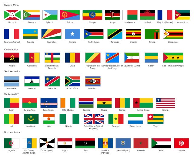
The vector stencils library "Africa flags" contains 61 clipart images of African countries state flags.
State flags of East Africa (Eastern Africa) countries and territories: Burundi, Comoros, Djibouti, Eritrea, Ethiopia, Kenya, Madagascar, Malawi, Mayotte (France), Mozambique, Réunion (France), Rwanda, Seychelles, Somalia, South Sudan, Tanzania, Uganda, Zambia, Zimbabwe.
State flags of Central Africa countries: Angola, Cameroon, Central African Republic, Chad, Republic of the Congo, Democratic Republic of the Congo, Equatorial Guinea, Gabon, São Tomé and Príncipe.
State flags of Southern Africa countries: Botswana, Lesotho, Namibia, South Africa, Swaziland.
State flags of West Africa (Western Africa) countries and territories: Benin, Burkina Faso, Cape Verde, Côte d'Ivoire, Gambia, Ghana, Guinea, Guinea-Bissau, Liberia, Mali, Mauritania, Niger, Nigeria, Saint Helena (United Kingdom), Senegal, Sierra Leone, Togo.
State flags of North Africa (Northern Africa) countries and territories: Algeria, The Canary Islands (Spain), Ceuta (Spain), Egypt, Libya, Madeira (Portugal), Melilla (Spain), Morocco, Sudan, Tunisia.
The clip art example "Design elements - Africa flags" was created using the ConceptDraw PRO diagramming and vector drawing software extended with the Continent Maps solution from the Maps area of ConceptDraw Solution Park.
Africa state flags
Geo Map - Africa - Zimbabwe

Geo Map - Africa - Algeria

Geo Map - Africa - Kenya

Geo Map - Africa - Lesotho

Geo Map - Africa - Mozambique

"East Africa or Eastern Africa is the easterly region of the African continent, variably defined by geography or geopolitics. In the UN scheme of geographic regions, 20 territories constitute Eastern Africa:
- Tanzania, Kenya, Uganda, Rwanda and Burundi – in Southeast Africa included in the African Great Lakes region and are members of the East African Community (EAC). Burundi and Rwanda are sometimes considered part of Central Africa.
- Djibouti, Eritrea, Ethiopia and Somalia – collectively known as the Horn of Africa.
- Mozambique and Madagascar – often considered part of Southern Africa. Madagascar has close cultural ties to Southeast Asia and the islands of the Indian Ocean.
- Malawi, Zambia and Zimbabwe – often included in Southern Africa, and formerly of the Central African Federation.
- Comoros, Mauritius and Seychelles – small island nations in the Indian Ocean.
- Réunion and Mayotte – French overseas territories also in the Indian Ocean.
- South Sudan – newly independent from Sudan." [East Africa. Wikipedia]
South Sudan has become independent on July 9, 2011. Sudan and South Sudan are shown with the new international border between them.
This East Africa political map was redesigned using the ConceptDraw PRO diagrammin and vector drawing software from the Wikimedia Commons file: Afryka Wschodnia.png.
[commons.wikimedia.org/ wiki/ File:Afryka_ Wschodnia.png]
The example "East Africa - Political map" is included in the Continent Maps solution from the Maps area of ConceptDraw Solution Park.
Political map - East Africa

Geo Map - South America Continent

Geo Map - Africa - Liberia

- Southern African Countries N There Flags
- Flags Of The Southern African Countries
- Flags Of Southern African Countries
- Flags Of Southern Africa
- Design elements - African country flags | Geo Map - Africa | Design ...
- Design elements - Africa flags | Geo Map - Africa | African country ...
- East Africa - Political map | West Africa countries | Geo Map - Asia ...
- South Africa Countries And Flags
- East Africa - Political map | West Africa countries | Geo Map - Africa ...
- Design elements - African country flags | Design elements - Africa ...
- All Africa Countries Names With Their Flags
- East Africa - Political map | West Africa countries | Geo Map - Asia ...
- All Africa Countries And Their Flags
- Southern Countries Flags
- Landlocked Countries In Africa According To Diagram
- African country flags
- Drawing Of A Map Of East Africa
- Design elements - Africa | Geo Map - Africa - Tanzania | Design ...
- Flags Of West African Countries
- Diagram For Africa Map Of Landlocked Countries