This site uses cookies. By continuing to browse the ConceptDraw site you are agreeing to our Use of Site Cookies.

Geo Map - South America - Nicaragua

Nicaragua, officially the Republic of Nicaragua, is the largest country in the Central American isthmus, bordering Honduras to the north and Costa Rica to the south.
The vector stencils library Nicaragua contains contours for ConceptDraw DIAGRAM diagramming and vector drawing software. This library is contained in the Continent Maps solution from Maps area of ConceptDraw Solution Park.
The vector stencils library "North America" contains 70 contours for drawing thematic maps of North America in spatial infographics.
Use it for visual representation of geospatial information, statistics and quantitative data in the ConceptDraw PRO diagramming and vector drawing software extended with the Spatial Infographics solution from the area "What is Infographics" of ConceptDraw Solution Park.
North America
North America, North America, North America map, North American countries,
Greenland (Denmark)
Greenland (Denmark), Greenland, Greenland map,
Canada
Canada, Canada, Canada map,
Canada (provinces and territories)
Canada (provinces and territories), Canada, Canada map, provinces, territories,
Alberta
Alberta, Alberta,
British Columbia
British Columbia, British Columbia,
Manitoba
Manitoba, Manitoba,
New Brunswick
New Brunswick, New Brunswick,
Newfoundland and Labrador
Newfoundland and Labrador, Newfoundland and Labrador,
Northwest Territories
Northwest Territories, Northwest Territories,
Nova Scotia
Nova Scotia, Nova Scotia,
Nunavut
Nunavut, Nunavut,
Ontario
Ontario, Ontario,
Prince Edward Island
Prince Edward Island, Prince Edward Island,
Quebec
Quebec, Quebec,
Saskatchewan
Saskatchewan, Saskatchewan,
Yukon
Yukon, Yukon,
USA
USA, USA, United States of America, U.S.A., United States, US, U.S., America,
US states
US states, USA, United States of America, U.S.A., United States, US, U.S., America,
Alabama
Alabama, Alabama,
Alaska
Alaska, Alaska,
Arizona
Arizona, Arizona,
Arkansas
Arkansas, Arkansas,
California
California, California,
Colorado
Colorado, Colorado,
Connecticut
Connecticut, Connecticut,
Delaware
Delaware, Delaware,
Florida
Florida, Florida,
Georgia
Georgia, Georgia,
Hawaii
Hawaii, Hawaii,
Idaho
Idaho, Idaho,
Illinois
Illinois, Illinois,
Indiana
Indiana, Indiana,
Iowa
Iowa, Iowa,
Kansas
Kansas, Kansas,
Kentucky
Kentucky, Kentucky,
Louisiana
Louisiana, Louisiana,
Maine
Maine, Maine,
Maryland
Maryland, Maryland,
Massachusetts
Massachusetts, Massachusetts,
Michigan
Michigan, Michigan,
Minnesota
Minnesota, Minnesota,
Mississippi
Mississippi, Mississippi,
Missouri
Missouri, Missouri,
Montana
Montana, Montana,
Nebraska
Nebraska, Nebraska,
Nevada
Nevada, Nevada,
New Hampshire
New Hampshire, New Hampshire,
New Jersey
New Jersey, New Jersey,
New Mexico
New Mexico, New Mexico,
New York
New York, New York,
North Carolina
North Carolina, North Carolina,
North Dakota
North Dakota, North Dakota,
Ohio
Ohio, Ohio,
Oklahoma
Oklahoma, Oklahoma,
Oregon
Oregon, Oregon,
Pennsylvania
Pennsylvania, Pennsylvania,
Rhode Island
Rhode Island, Rhode Island,
South Carolina
South Carolina, South Carolina,
South Dakota
South Dakota, South Dakota,
Tennessee
Tennessee, Tennessee,
Texas
Texas, Texas,
Utah
Utah, Utah,
Vermont
Vermont, Vermont,
Virginia
Virginia, Virginia,
Washington
Washington, Washington,
West Virginia
West Virginia, West Virginia,
Wisconsin
Wisconsin, Wisconsin,
Wyoming
Wyoming, Wyoming,
Mexico
Mexico, Mexico,

Geo Map - Asia - North Korea

North Korea, officially the Democratic People's Republic of Korea, is a country in East Asia, in the northern part of the Korean Peninsula.
The vector stencils library North Korea contains contours for ConceptDraw DIAGRAM diagramming and vector drawing software. This library is contained in the Continent Maps solution from Maps area of ConceptDraw Solution Park.

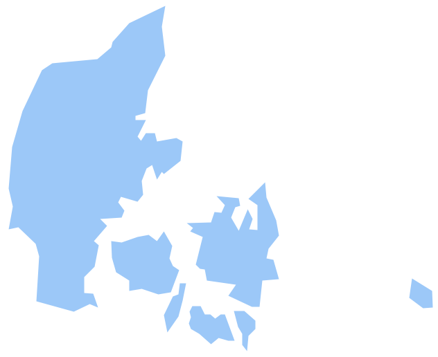
Geo Map - Europe - Denmark

The vector stencils library Denmark contains contours for ConceptDraw DIAGRAM diagramming and vector drawing software. This library is contained in the Continent Maps solution from Maps area of ConceptDraw Solution Park.

Geo Map - USA - North Dakota

North Dakota is the 39th state of the United States, having been admitted to the union on November 2, 1889.
The vector stencils library North Dakota contains contours for ConceptDraw DIAGRAM diagramming and vector drawing software. This library is contained in the Continent Maps solution from Maps area of ConceptDraw Solution Park.

Geo Map - USA - North Carolina

North Carolina is a state in Southeastern United States.
The vector stencils library North Carolina contains contours for ConceptDraw DIAGRAM diagramming and vector drawing software. This library is contained in the Continent Maps solution from Maps area of ConceptDraw Solution Park.

Geo Map - Europe - Norway

The vector stencils library Norway contains contours for ConceptDraw DIAGRAM diagramming and vector drawing software. This library is contained in the Continent Maps solution from Maps area of ConceptDraw Solution Park.
The vector stencils library "Map symbols" contains 19 symbols for labeling the maps.
The pictograms example "Map symbols - Vector stencils library" was created using the ConceptDraw PRO diagramming and vector drawing software extended with the Directional Maps solution from the Maps area of ConceptDraw Solution Park.
Compass
Compass, compass, direction,
North
North, North,
North arrow 1
North arrow 1, North,
North arrow 2
North arrow 2, North,
North arrow 3
North arrow 3, North,
North arrow 4
North arrow 4, North,
North arrow 5
North arrow 5, North,
Scale
Scale, scale,
Scale symbol 1
Scale symbol 1, scale,
Scale symbol 2
Scale symbol 2, scale,
Horizontal
Horizontal, dimension,
Vertical
Vertical, dimension,
Callout
Callout,
Church
Church, church,
Cathedral
Cathedral, cathedral,
Viewpoint
Viewpoint, viewpoint,
Castle
Castle, castle,
Ruins
Ruins, ruins,
Curiosity
Curiosity, curiosity,
HelpDesk

How to Draw a Map of North America

Geographic maps, cardiograms, and thematic maps are often used for geographical visualization of business information. Any country can inspire a wealth of geopolitical statistical data. A common way of assimilating this data is to create maps that convey a particular theme or subject matter in relation to a specific geographical area. Known as thematic maps, they cover themes such as population density, average rainfall, or political allegiance, differentiating the data by using graphical elements and annotation. Thematic maps contrast general reference maps, which tend to display information on a variety of subjects — vegetation, topology, roads, and highways, for example. A thematic map will always focus on one particular subject matter. ConceptDraw DIAGRAM can be helpful as a tool for creating maps of countries and regions of the world. It allows you to draw continental maps quickly and easily using the special templates and vector stencils libraries.

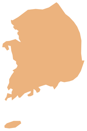
Geo Map - Asia - South Korea

South Korea, officially the Republic of Korea, is a country in East Asia, constituting the southern part of the Korean Peninsula.
The vector stencils library South Korea contains contours for ConceptDraw DIAGRAM diagramming and vector drawing software. This library is contained in the Continent Maps solution from Maps area of ConceptDraw Solution Park.