Geo Map — United States of America Map

Geo Map of Americas

Use this template of North America map with contours of North American countries, capitals and main cities to design your political or thematic map. This North America map template for the ConceptDraw PRO diagramming and vector drawing software is included in the Continent Maps solution from the Maps area of ConceptDraw Solution Park.
North America map template

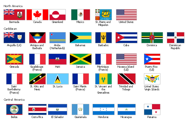
The vector stencils library "North and Central America country flags" contains 26 North and Central American state flags clipart.
Use this clip art library to illustrate your business documents, presentation slides, webpages, infographics.
The clip art example "Design elements - North and Central America country flags" was created using the ConceptDraw PRO diagramming and vector drawing software extended with the Artwork solution from the Illustration area of ConceptDraw Solution Park.
North and Central American state flags clip art
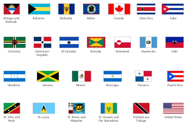
The vector stencils library "North and Central America flags" contains 35 state flags of North and Central American countries.
The clip art example "Design elements - North and Central America flags" was created using the ConceptDraw PRO diagramming and vector drawing software extended with the Continent Maps solution from the Maps area of ConceptDraw Solution Park.
The clip art example "Design elements - North and Central America flags" was created using the ConceptDraw PRO diagramming and vector drawing software extended with the Continent Maps solution from the Maps area of ConceptDraw Solution Park.
North and Central America state flags
Use this template to design your North America political map, cartogram or thematic map, to visualize your spatial business information connected with geographic areas, locations or ways.
This North America map template for the ConceptDraw PRO diagramming and vector drawing software is included in the Continent Maps solution from the Maps area of ConceptDraw Solution Park.
This North America map template for the ConceptDraw PRO diagramming and vector drawing software is included in the Continent Maps solution from the Maps area of ConceptDraw Solution Park.
North America thematic map template

Map of USA

The vector stencils library "United States of America" contains 53 state map contours for drawing thematic maps of USA.
Use it for visual representation of geospatial information, statistics and quantitative data.
The state map contours example "United States of America - Vector stencils library" was created using the ConceptDraw PRO diagramming and vector drawing software extended with the Continent Maps solution from the Maps area of ConceptDraw Solution Park.
USA (color)
-united-states-of-america---vector-stencils-library.png--diagram-flowchart-example.png)
USA

Alabama

Alaska

Arizona

Arkansas

California

Colorado

Connecticut

Delaware

Florida

Georgia

Hawaii

Idaho

Illinois

Indiana

Iowa

Kansas

Kentucky

Louisiana

Maine

Maryland

Massachusetts

Michigan

Minnesota

Mississippi

Missouri

Montana

Nebraska

Nevada

New Hampshire

New Jersey

New York

New Mexico

North Dakota

North Carolina

Ohio

Oklahoma

Oregon

Pennsylvania

Rhode Island

South Carolina

South Dakota

Tennessee

Texas

Utah

Vermont

Virginia

Washington

West Virginia

Wisconsin

Wyoming

Great Lakes

Use this template to design your North America political map, cartogram or thematic map, to visualize your spatial business information connected with geographic areas, locations or ways.
This North America map template for the ConceptDraw PRO diagramming and vector drawing software is included in the Continent Maps solution from the Maps area of ConceptDraw Solution Park.
This North America map template for the ConceptDraw PRO diagramming and vector drawing software is included in the Continent Maps solution from the Maps area of ConceptDraw Solution Park.
North America thematic map template
Geo Map - USA - North Carolina

- Geo Map - South America Continent | North America States List In ...
- North America map with capitals - Template | Geo Map — United ...
- Geo Map - South America Continent | Northern American States ...
- North America States In Hindi Name
- North American States And His Capitals
- Geo Map — United States of America Map | Design elements - North ...
- Geo Map - United States of America Map | North and Central ...
- North America States And Capitals
- Geo Map - South America Continent | Usa Map In Hindi States And ...
- Geo Map - South America Continent | Country Capital Of North ...