Cross-Functional Process Map Template

HelpDesk
How to Start Mind Mapping from a Custom Template


Value Stream Mapping Template

"A transit map is a topological map in the form of a schematic diagram used to illustrate the routes and stations within a public transport system - whether this be bus lines, tramways, rapid transit, commuter rail or ferry routes. The main components are color coded lines to indicate each line or service, with named icons to indicate stations or stops.
Transit maps can be found in the transit vehicles, at the platforms or in printed timetables. Their primary function is to help users to efficiently use the public transport system, including which stations function as interchange between lines. Unlike conventional maps, transit maps are usually not geographically accurate - instead they use straight lines and fixed angles, and often illustrate a fixed distance between stations, compressing those in the outer area of the system and expanding those close to the center." [Transit map. Wikipedia]
This transit map template for the ConceptDraw PRO diagramming and vector drawing software is included in the Metro Map solution from the Maps area of ConceptDraw Solution Park.
www.conceptdraw.com/ solution-park/ maps-metro-map
Transit map

"A transit map is a topological map in the form of a schematic diagram used to illustrate the routes and stations within a public transport system - whether this be bus lines, tramways, rapid transit, commuter rail or ferry routes. The main components are color coded lines to indicate each line or service, with named icons to indicate stations or stops. ...
There are a growing number of books, websites and works of art on the subject of urban rail and metro map design and use. There are now hundreds of examples of diagrams in an urban rail or metro map style that are used to represent everything from other transit networks like buses and national rail services to sewerage systems and Derbyshire public houses." [Transit map. Wikipedia]
The transportation map template for the ConceptDraw PRO diagramming and vector drawing software is included in the Spatial Infographics solution from the area "What is Infographics" of ConceptDraw Solution Park.
Transit map

Metro Maps

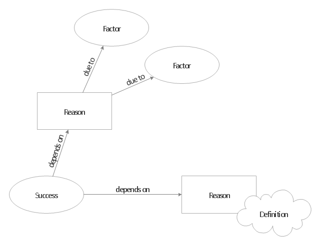
"A concept map is a diagram that depicts suggested relationships between concepts. It is a graphical tool that designers, engineers, technical writers, and others use to organize and structure knowledge. A concept map typically represents ideas and information as boxes or circles, which it connects with labeled arrows in a downward-branching hierarchical structure. The relationship between concepts can be articulated in linking phrases such as causes, requires, or contributes to. The technique for visualizing these relationships among different concepts is called concept mapping. Concept maps define the ontology of computer systems, for example with the object role modeling or Unified Modeling Language formalism." [Concept map. Wikipedia]
The concept map template for the ConceptDraw PRO diagramming and vector drawing software is included in the Concept Maps solution from the area "What is a Diagram" of ConceptDraw Solution Park.
The concept map template for the ConceptDraw PRO diagramming and vector drawing software is included in the Concept Maps solution from the area "What is a Diagram" of ConceptDraw Solution Park.
Concept map template
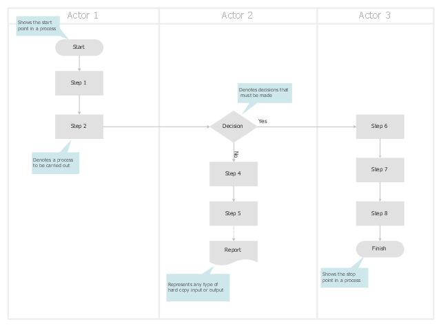
Swim lane business process maps are the type of flow charts that show the organization structure. The maps arranged on a table where the columns or rows display the actors responsible for the steps. The actors may be persons, departments or organizations. Swim lane maps are used to defining of the process bottlenecks and overloaded resources.
The swim lane business process map template for the ConceptDraw PRO diagramming and vector drawing software is included in the Cross-Functional Flowcharts solution from the Business Processes area of ConceptDraw Solution Park.
The swim lane business process map template for the ConceptDraw PRO diagramming and vector drawing software is included in the Cross-Functional Flowcharts solution from the Business Processes area of ConceptDraw Solution Park.
Swim lane process map template
Use this template for creating the directional maps, location plans, site schemes, transit schemes, road maps, route maps.
"A road map or route map is a map that primarily displays roads and transport links rather than natural geographical information. It is a type of navigational map that commonly includes political boundaries and labels, making it also a type of political map. In addition to roads and boundaries, road maps often include points of interest, such as prominent businesses or buildings, tourism sites, parks and recreational facilities, hotels and restaurants, as well as airports and train stations. A road map may also document non-automotive transit routes, although often these are found only on transit maps." [Road map. Wikipedia]
This template for the ConceptDraw PRO diagramming and vector drawing software is included in the Directional Maps solution from the Maps area of ConceptDraw Solution Park.
Directional map template

Use this template to design your North America political map, cartogram or thematic map, to visualize your spatial business information connected with geographic areas, locations or ways.
This North America map template for the ConceptDraw PRO diagramming and vector drawing software is included in the Continent Maps solution from the Maps area of ConceptDraw Solution Park.
This North America map template for the ConceptDraw PRO diagramming and vector drawing software is included in the Continent Maps solution from the Maps area of ConceptDraw Solution Park.
North America thematic map template

Use this template of North America map with contours of North American countries, capitals and main cities to design your political or thematic map. This North America map template for the ConceptDraw PRO diagramming and vector drawing software is included in the Continent Maps solution from the Maps area of ConceptDraw Solution Park.
North America map template

Positioning Map

How To create Value Stream Map (VSM)

Use this template of South America map with contours of South American countries, capitals and main cities to design your political or thematic map. This South America map template for the ConceptDraw PRO diagramming and vector drawing software is included in the Continent Maps solution from the Maps area of ConceptDraw Solution Park.
South America map

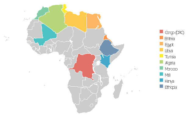
Use this template to design your Africa political map, cartogram or thematic map, to visualize your spatial business information connected with geographic areas, locations or ways.
This Africa map template for the ConceptDraw PRO diagramming and vector drawing software is included in the Continent Maps solution from the Maps area of ConceptDraw Solution Park.
This Africa map template for the ConceptDraw PRO diagramming and vector drawing software is included in the Continent Maps solution from the Maps area of ConceptDraw Solution Park.
Africa thematic map template
- Cross-Functional Process Map Template | Business Process ...
- Australia map - Template | Geo Map - Australia - New Zealand ...
- Cross-Functional Process Map Template | Process Flowchart | Swim ...
- Value Stream Mapping Template
- Concept map - Template
- Time Function Mapping Template
- Transit map template | Transport map - Template | Metro Map ...
- Direction Map Templates
- Process Mapping Template Free Download Mac
- Transport map - Template | Transit map template | Metro Maps ...
- Concept map - Template | Value Stream Mapping | Basic ...
- Value Stream Mapping Template Visio
- Maps and Directions | Value Stream Mapping Template | Directions ...
- Value stream map - Template | Process Flowchart | SWOT Analysis ...
- Template Downloads For Concept Maps
- 3D pictorial road map | 2D Directional map - Template | Map ...
- Australia map with cities - Template | Australia map - Template ...
- Transit map template
- How to Start Mind Mapping from a Custom Template | How to ...
- 2D Directional map - Template | How To use House Electrical Plan ...