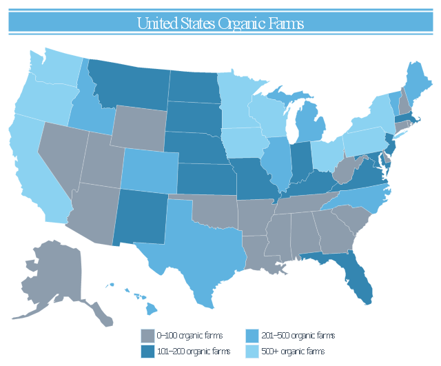
Geo Map — United States of America Map

This infogram sample was redesigned from the Wikimedia Commons file: 2007 United States Organic Farms.svg.
"A map of the United States showing the number of organic farms per state in 2007." [commons.wikimedia.org/ wiki/ File:2007_ United_ States_ Organic_ Farms.svg]
This file is licensed under the Creative Commons Attribution-Share Alike 3.0 Unported license. [creativecommons.org/ licenses/ by-sa/ 3.0/ deed.en]
"Organic farming is a form of agriculture that relies on techniques such as crop rotation, green manure, compost, and biological pest control. Depending on whose definition is used, organic farming uses fertilizers and pesticides (which include herbicides, insecticides and fungicides) if they are considered natural (such as bone meal from animals or pyrethrin from flowers), but it excludes or strictly limits the use of various methods (including synthetic petrochemical fertilizers and pesticides; plant growth regulators such as hormones; antibiotic use in livestock; genetically modified organisms; human sewage sludge; and nanomaterials.) for reasons including sustainability, openness, independence, health, and safety." [Organic farming. Wikipedia]
The thematic map example "United States organic farms" was created using the ConceptDraw PRO diagramming and vector drawing software extended with the Management Infographics solition from the area "Business Infographics" in ConceptDraw Solution Park.
US thematic map
 USA Maps
Use the USA Maps solution to create a map of USA, a US interstate map, printable US maps, US maps with cities and US maps with capitals. Create a complete USA states map.
A color-coded map showing US state-by-state status of Benefit Corporation legislation.
"A thematic map is a type of map or chart especially designed to show a particular theme connected with a specific geographic area. These maps "can portray physical, social, political, cultural, economic, sociological, agricultural, or any other aspects of a city, state, region, nation, or continent"." [Thematic map. Wikipedia]
This U.S.A. thematic map was redesigned from Wikipedia file: Benefit Corporation Map 2012 05 16.svg. [commons.wikimedia.org/ wiki/ File:Benefit_ Corporation_ Map_ 2012_ 05_ 16.svg]
This file is licensed under the Creative Commons Attribution-Share Alike 3.0 Unported license.
[creativecommons.org/ licenses/ by-sa/ 3.0/ deed.en]
This U.S. thematic map example was created using the ConceptDraw PRO diagramming and vector drawing software extended with the Continent Maps solution from the Maps area of ConceptDraw Solution Park.
Thematic map of U.S.

HelpDesk
How to Draw a Map of USA States

HelpDesk
How to Draw Maps of Australia

Map of USA

Geo Map - USA - West Virginia

Map of USA States

Geo Map - USA - Maryland

Geo Map — USA — Alaska

Geo Map - USA - California

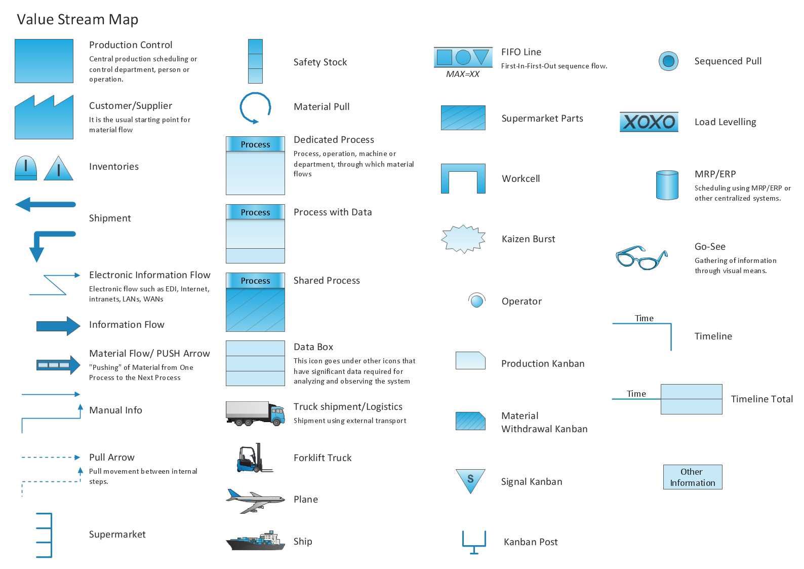
Learn how to create a current state value stream map
Geo Map — USA — Wisconsin

Geo Map of Americas

- Benefit Corporation legislation - Thematic map | Ranks US states by ...
- Usa Map Showing States
- Geo Map - United States of America Map | Continent Maps ...
- Geo Map - United States of America Map | Geo Map - USA ...
- Map of USA with state names | Benefit Corporation legislation ...
- Geo Map - United States of America Map | Map of USA with state ...
- Geo Map - United States of America Map | Geo Map - USA - Alaska ...
- Geo Map - United States of America Map | Geo Map - USA - Iowa ...
- Geo Map - United States of America Map | USA Maps | Geo Map ...
- Geo Map - United States of America Map | Geo Map - USA - Alaska ...
- Us Color Coded Map
- How to Draw a Map of USA States Using ConceptDraw PRO | Map ...
- Geo Map - United States of America Map | USA Map States | Map of ...
- Continent Maps | Geo Map of Americas | Geo Map - United States of ...
- Geo Map - United States of America Map | Map of USA States | How ...
- Geo Map - United States of America Map | USA Maps | Map of USA ...
- Geo Map - United States of America Map | How to Draw a Map of ...
- Ranks US states by peacefulness | Geo Map - United States of ...
- USA Maps | Geo Map - United States of America Map | USA Maps ...
- US State Map