HelpDesk
How to Create a Genogram

 UK Map
The Map of UK solution contains collection of professionally designed samples and scalable vector stencil graphics maps, representing the United Kingdom counties, regions and cities. Use the Map of UK solution from ConceptDraw Solution Park as the base fo
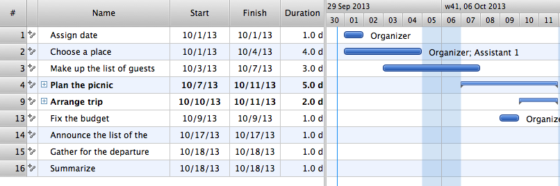
Managing the task list
 Website Wireframe
The innovative Website Wireframe solution enhances the ConceptDraw DIAGRAM functionality with newest wireframe tools, libraries with variety of predesigned icons, symbols, buttons, graphics, forms, boxes, and many other vector elements, templates and professionally designed samples, which make it the best wireframing software. Website Wireframe solution gives you significant advantages when designing and maintaining websites, creating skeletal and content-free depictions of website structure, making website prototypes and planning the content arrangement before committing to design, also speeds up the processes of sketching, producing and sharing wireframe examples of website style and interface design.
The vector stencils library "Northern constellations" contains 6 icons of Northern constellation maps.
Use these star charts for drawing astronomical diagrams and illustrations in ConceptDraw PRO diagramming and vector drawing software extended with the Astronomy solution from the Science and Education area in ConceptDraw Solution Park.
Use these star charts for drawing astronomical diagrams and illustrations in ConceptDraw PRO diagramming and vector drawing software extended with the Astronomy solution from the Science and Education area in ConceptDraw Solution Park.
Ursa Minor
---vector-stencils-library.png--diagram-flowchart-example.png)
Draco
---vector-stencils-library.png--diagram-flowchart-example.png)
Cassiopeia
---vector-stencils-library.png--diagram-flowchart-example.png)
Cepheus
---vector-stencils-library.png--diagram-flowchart-example.png)
Camelopardalis
---vector-stencils-library.png--diagram-flowchart-example.png)
Ursa Major
---vector-stencils-library.png--diagram-flowchart-example.png)
Geo Map — United States of America Map

Geo Map — United States of America Map
- Design elements - UML use case diagrams | Design elements - Use ...
- Involvement matrix - Distribution of responsibilities | Strategic ...
- Northern constellations (45-90 degrees) - Vector stencils library
- Flowchart design . Flowchart symbols, shapes, stencils and icons ...
- Organizational Charts | USA Maps | New application workflow ...
- Pie Charts | Logistics Flow Charts | How to Create a Pie Chart ...
- Schedule pie chart - Daily action plan | Chart Maker for ...