 Germany Map
The Germany Map solution contains collection of samples, templates and scalable vector stencil graphic maps, representing map of Germany and all 16 states of Germany. Use the Germany Map solution from ConceptDraw Solution Park as the base for various them
USA Maps

 Directional Maps
Directional Maps solution extends ConceptDraw DIAGRAM software with templates, samples and libraries of vector stencils for drawing the directional, location, site, transit, road and route maps, plans and schemes.
Maps Driving Directions
Map of USA States

 USA Maps
Use the USA Maps solution to create a map of USA, a US interstate map, printable US maps, US maps with cities and US maps with capitals. Create a complete USA states map.
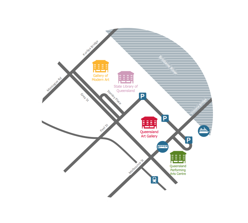
This travelling map sample was created on the base of the location map from the website of the Queensland Art Gallery | Gallery of Modern Art (QAGOMA). "Queensland's premier visual arts institution, the Queensland Art Gallery | Gallery of Modern Art (QAGOMA), connects people and art through a dynamic program of Australian and international exhibitions that showcase works from a diverse range of historical and contemporary artists.
Enriching the cultural life of Brisbane, these two vibrant and accessible galleries, the Queensland Art Gallery (QAG) and the Gallery of Modern Art (GOMA), offer distinct, yet complementary experiences.
QAGOMA’s highly acclaimed Children’s Art Centre presents engaging and interactive exhibitions and events for visitors of all ages and the cinemas at GOMA feature films by influential and popular film makers and artists. ...
The Queensland Art Gallery (QAG) and Gallery of Modern Art (GOMA) are located 150 metres from each other, on the south bank of the Brisbane River. Entrance to both buildings is possible from Stanley Place, and the river front entrance to the Queensland Art Gallery is on Melbourne Street. The Galleries are within easy walking distance to the city centre and South Bank Parklands." [qagoma.qld.gov.au/ visiting-us]
The locator map example "Travelling to the Gallery" was created using the ConceptDraw PRO diagramming and vector drawing software extended with the Directional Maps solution from the Maps area of ConceptDraw Solution Park.
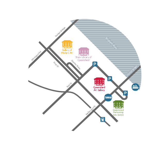
Travelling map
 Australia Map
For graphic artists creating accurate maps of Australia. The Australia Map solution - allows designers to map Australia for their needs, offers a collection of scalable graphics representing the political geography of Australia, split into distinct state
 UK Map
The Map of UK solution contains collection of professionally designed samples and scalable vector stencil graphics maps, representing the United Kingdom counties, regions and cities. Use the Map of UK solution from ConceptDraw Solution Park as the base fo
The 3D pictorial street maps are used as road maps, route maps, locator maps, transit maps, directional maps, tourist maps with points of interest (POI).
"A point of interest, or POI, is a specific point location that someone may find useful or interesting. ...
Most consumers use the term when referring to hotels, campsites, fuel stations or any other categories used in modern (automotive) navigation systems. ...
The term is widely used in cartography, especially in electronic variants including GIS, and GPS navigation software. In this context the synonym waypoint is common.
A GPS point of interest specifies, at minimum, the latitude and longitude of the POI, assuming a certain map datum. A name or description for the POI is usually included, and other information such as altitude or a telephone number may also be attached. GPS applications typically use icons to represent different categories of POI on a map graphically." [Point of interest. Wikipedia]
The example "3D pictorial street map" was created using the ConceptDraw PRO diagramming and vector drawing software extended with the Directional Maps solution from the Maps area of ConceptDraw Solution Park.
3D pictorial street map

- Hotel locator map | Rolla USGS Center locator map | Locator map of ...
- Locator map
- Floor Plans | Basic Network Diagram | Network Diagram Examples ...
- Tools - Vector stencils library | Rolla USGS Center locator map ...
- Rolla USGS Center locator map | Audio, Video, Media | Applications ...
- Hotel Emergency Exit Map
- Geo Map - USA - Missouri | Rolla USGS Center locator map | Geo ...
- Hotel locator map | Design elements - 3D directional maps | Design ...
- Rolla USGS Center locator map | Operational Level Management ...
- Example Of A Map House To School