"East Africa or Eastern Africa is the easterly region of the African continent, variably defined by geography or geopolitics. In the UN scheme of geographic regions, 20 territories constitute Eastern Africa:
- Tanzania, Kenya, Uganda, Rwanda and Burundi – in Southeast Africa included in the African Great Lakes region and are members of the East African Community (EAC). Burundi and Rwanda are sometimes considered part of Central Africa.
- Djibouti, Eritrea, Ethiopia and Somalia – collectively known as the Horn of Africa.
- Mozambique and Madagascar – often considered part of Southern Africa. Madagascar has close cultural ties to Southeast Asia and the islands of the Indian Ocean.
- Malawi, Zambia and Zimbabwe – often included in Southern Africa, and formerly of the Central African Federation.
- Comoros, Mauritius and Seychelles – small island nations in the Indian Ocean.
- Réunion and Mayotte – French overseas territories also in the Indian Ocean.
- South Sudan – newly independent from Sudan." [East Africa. Wikipedia]
South Sudan has become independent on July 9, 2011. Sudan and South Sudan are shown with the new international border between them.
This East Africa political map was redesigned using the ConceptDraw PRO diagrammin and vector drawing software from the Wikimedia Commons file: Afryka Wschodnia.png.
[commons.wikimedia.org/ wiki/ File:Afryka_ Wschodnia.png]
The example "East Africa - Political map" is included in the Continent Maps solution from the Maps area of ConceptDraw Solution Park.
Political map - East Africa

Geo Map - Africa

Geo Map - Africa - Tanzania

Geo Map - Africa - Rwanda

Geo Map - Africa - Kenya

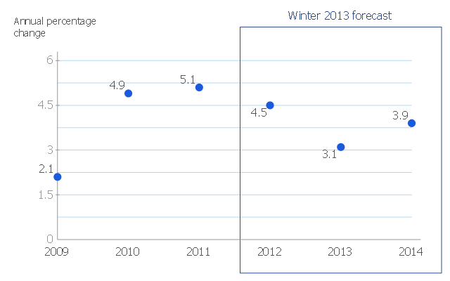
This scatter chart sample shows the MENA's (Middle East and North Africa's) real GDP growth. It was designed on the base scatter graph from the website of the European Economic Forecast (EUROPEAN ECONOMY 1|2013, Economic and Financial Affairs Winter 2013, European Commission). [ec.europa.eu/ economy_ finance/ publications/ european_ economy/ 2013/ pdf/ ee1_ en.pdf]
"The term MENA, for "Middle East and North Africa", is an acronym often used in academic, military planning, disaster relief, and business writing.
Due to the geographic ambiguity and Eurocentric nature of the term "Middle East", many people prefer use of the term WANA (West Asia and North Africa) or the less common NAWA (North Africa-West Asia).
The term covers an extensive region, extending from Morocco to Iran, including the majority of both the Middle Eastern and Maghreb countries. The term is roughly synonymous with the term the Greater Middle East. ...
MENA has no standardized definition; different organizations define the region as consisting of different territories. The following is a list of commonly included countries and territories: Bahrain, Egypt, Iran, Iraq, Israel, Jordan, Kuwait, Lebanon, Yemen, United Arab Emirates, Libya, Morocco, Oman, West Bank and Gaza, Qatar, Saudi Arabia, Syria, Tunisia, Algeria.
Sometimes also included in broader definitions: Armenia, Azerbaijan, Cyprus, Djibouti, Mauritania, Somalia, Sudan, Turkey, Western Sahara." [MENA. Wikipedia]
The scatter chart example "Middle East and North Africa's real GDP growth" was created using the ConceptDraw PRO diagramming and vector drawing software extended with the Line Graphs solution from the Graphs and Charts area of ConceptDraw Solution Park.
Scatter graph
Geo Map - Africa - Chad

Geo Map - Africa - Uganda

Geo Map - Africa - Malawi

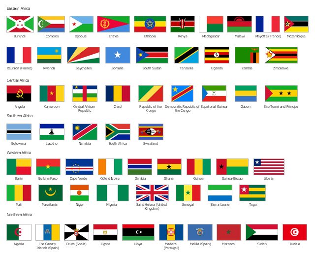
The vector stencils library "Africa flags" contains 61 clipart images of African countries state flags.
State flags of East Africa (Eastern Africa) countries and territories: Burundi, Comoros, Djibouti, Eritrea, Ethiopia, Kenya, Madagascar, Malawi, Mayotte (France), Mozambique, Réunion (France), Rwanda, Seychelles, Somalia, South Sudan, Tanzania, Uganda, Zambia, Zimbabwe.
State flags of Central Africa countries: Angola, Cameroon, Central African Republic, Chad, Republic of the Congo, Democratic Republic of the Congo, Equatorial Guinea, Gabon, São Tomé and Príncipe.
State flags of Southern Africa countries: Botswana, Lesotho, Namibia, South Africa, Swaziland.
State flags of West Africa (Western Africa) countries and territories: Benin, Burkina Faso, Cape Verde, Côte d'Ivoire, Gambia, Ghana, Guinea, Guinea-Bissau, Liberia, Mali, Mauritania, Niger, Nigeria, Saint Helena (United Kingdom), Senegal, Sierra Leone, Togo.
State flags of North Africa (Northern Africa) countries and territories: Algeria, The Canary Islands (Spain), Ceuta (Spain), Egypt, Libya, Madeira (Portugal), Melilla (Spain), Morocco, Sudan, Tunisia.
The clip art example "Design elements - Africa flags" was created using the ConceptDraw PRO diagramming and vector drawing software extended with the Continent Maps solution from the Maps area of ConceptDraw Solution Park.
Africa state flags
Geo Map - Africa - Zambia

Geo Map - Africa - Mozambique

Geo Map - Africa - Sudan

Geo Map - Africa - Angola

Geo Map - Africa - Djibouti

- East Africa - Political map | West Africa countries | Geo Map - Asia ...
- East Africa - Political map | Geo Map - Asia - Papua New Guinea ...
- Geo Map - Asia - Papua New Guinea | South Asia - Political map ...
- Geo Map - Africa - Madagascar | East Africa - Political map | Geo ...
- Drawing Of A Map Of East Africa
- Geo Map - Africa - Tanzania | East Africa - Political map | Africa flags ...
- Geo Map - Africa - Malawi | Geo Map - Africa - Madagascar | East ...
- Geo Map - Asia - India | South Asia - Political map | East Africa ...
- Africa - Vector stencils library | East Africa - Political map | West ...
- South Africa Map Outline Png
- South America regions - Political map | East Africa - Political map ...
- Continent Of East Africa Map
- East Africa Map Drawings
- East Africa - Political map | Asia - Vector stencils library | Africa ...
- Geographical Map Of East Africa
- Geo Map - Asia - Philippines | East Africa - Political map | Geo Map ...
- Geo Map - Africa - Tanzania
- Geo Map - Africa | East Africa - Political map | Geo Map - Africa ...
- Geo Map - Africa - Madagascar | Geo Map - Africa | East Africa ...
- East Africa - Political map