The vector stencils library "Africa flags" contains 61 clipart images of African countries state flags.
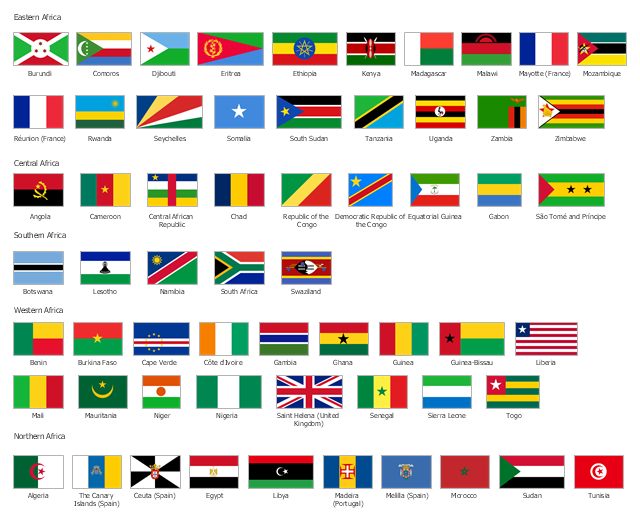
State flags of East Africa (Eastern Africa) countries and territories: Burundi, Comoros, Djibouti, Eritrea, Ethiopia, Kenya, Madagascar, Malawi, Mayotte (France), Mozambique, Réunion (France), Rwanda, Seychelles, Somalia, South Sudan, Tanzania, Uganda, Zambia, Zimbabwe.
State flags of Central Africa countries: Angola, Cameroon, Central African Republic, Chad, Republic of the Congo, Democratic Republic of the Congo, Equatorial Guinea, Gabon, São Tomé and Príncipe.
State flags of Southern Africa countries: Botswana, Lesotho, Namibia, South Africa, Swaziland.
State flags of West Africa (Western Africa) countries and territories: Benin, Burkina Faso, Cape Verde, Côte d'Ivoire, Gambia, Ghana, Guinea, Guinea-Bissau, Liberia, Mali, Mauritania, Niger, Nigeria, Saint Helena (United Kingdom), Senegal, Sierra Leone, Togo.
State flags of North Africa (Northern Africa) countries and territories: Algeria, The Canary Islands (Spain), Ceuta (Spain), Egypt, Libya, Madeira (Portugal), Melilla (Spain), Morocco, Sudan, Tunisia.
The clip art example "Design elements - Africa flags" was created using the ConceptDraw PRO diagramming and vector drawing software extended with the Continent Maps solution from the Maps area of ConceptDraw Solution Park.
Africa state flags
The vector stencils library "African country flags" contains 54 Africa state flags clipart.
Use it to illustrate your business documents, presentation slides, web pages and infographics.
The clip art example "Design elements - African country flags" was created using the ConceptDraw PRO diagramming and vector drawing software extended with the Artwork solution from the Illustration area of ConceptDraw Solution Park.
African state flags clip art

Geo Map - Africa

Geo Map - Africa - Morocco

Geo Map - South America Continent

 Continent Maps
Continent Maps solution extends ConceptDraw PRO software with templates, samples and libraries of vector stencils for drawing the thematic maps of continents, state maps of USA and Australia.
Geo Map - Asia - India

Geo Map - Asia

Geo Map - Asia - Mongolia

Geo Map - Africa - South Africa

Geo Map - Africa - Kenya

Geo Map - Africa - Malawi

Geo Map - Europe - Serbia

Geo Map - Europe

Geo Map - Africa - Togo

- Design elements - Africa flags | Geo Map - South America Continent ...
- Design elements - African country flags | Geo Map - Africa | Design ...
- Africa flags - Stencils library | Geo Map - Africa | Design elements ...
- Design elements - Africa flags | Design elements - African country ...
- Africa flags - Stencils library | Design elements - Africa flags | Geo ...
- Design elements - African country flags | Design elements - Africa ...
- Design elements - African country flags | Geo Map - Africa - Zambia ...
- Design elements - Africa flags | Africa flags - Stencils library | Flags ...
- Design elements - Africa flags | Design elements - South America ...
- Design elements - Africa flags | Africa flags - Stencils library | African ...
- Design elements - Africa flags | Africa flags - Stencils library | Geo ...
- Design elements - African country flags | Map of Continents | Afican ...
- Design elements - Africa flags | Geo Map - Africa | Geo Map - Africa ...
- Design elements - African country flags
- Design elements - Asia flags | Asia flags - Stencils library | Design ...
- Design elements - African country flags | African country flags ...
- Geo Map - Africa | Geo Map - Africa - Morocco | Design elements ...
- Design elements - African country flags | Geo Map - Africa | Geo Map ...
- Geo Map - Africa | Design elements - African country flags | Geo Map ...
- Geo Map - Africa - South Africa | Design elements - African country ...