 Continent Maps
Continent Maps solution extends ConceptDraw PRO software with templates, samples and libraries of vector stencils for drawing the thematic maps of continents, state maps of USA and Australia.
Geo Map - Europe

ConceptDraw PRO is idea to draw the geological maps of Europe from the pre-designed vector geo map shapes.
Use it to draw thematic maps, geospatial infographics and vector illustrations for your business documents, presentations and websites.
Types of Map - Overview

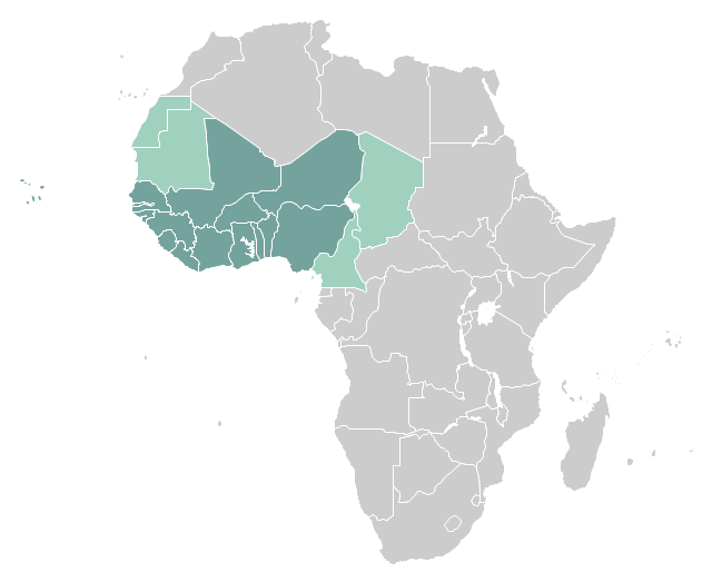
"West Africa, also called Western Africa and the West of Africa, is the westernmost region of the African continent. In line with the current membership of the Economic Community of West African States (ECOWAS), West Africa has been defined in Africa as including the fifteen countries of Benin, Burkina Faso, Cape Verde, Gambia, Ghana, Guinea, Guinea-Bissau, Ivory Coast, Liberia, Mali, Niger, Nigeria, Senegal, Sierra Leone and Togo." [West Africa. Wikipedia]
This example West Africa countries map was redesigned from the Wikimedia Commons file: Afryka Zachodnia.png.
[commons.wikimedia.org/ wiki/ File:Afryka_ Zachodnia.png]
The political map example "West Africa countries" was created using ConceptDraw PRO diagramming and vector drawing software extended with the Continent Map solution from the Maps area of ConceptDraw Solution Park.
Political map - West Africa
Geo Map - Asia - Philippines

Use the Continent Maps solution and Philippines library to draw thematic maps, geospatial infographics and vector illustrations. This solution to help visualize the business and thematic information connected with geographic areas, locations or customs; for your business documents, presentations and websites.
Geo Map - Africa

Vector design elements library Africa contains country map contours, geographical maps, cartograms and thematic maps for ConceptDraw PRO diagramming and vector drawing software. To help visualize the business and thematic information connected with geographic areas, locations or customs.
All ConceptDraw PRO documents are vector graphic files and are available for reviewing, modifying, and converting to a variety of formats: image, HTML, PDF file, MS PowerPoint Presentation, Adobe Flash, MS Visio (.VDX, .VSDX).
World Continents Map

Geo Map - Europe - France

Geo Map - Africa - Malawi

The vector stencils library Malawi contains contours for ConceptDraw PRO diagramming and vector drawing software. This library is contained in the Continent Maps solution from Maps area of ConceptDraw Solution Park.
Map Software

Geo Map - Europe - Belarus

Geo Map - Europe - Bulgaria

Use the Continent Maps solution to create Bulgaria geographical map, cartograms and thematic map, to help visualize the business and thematic information connected with geographic areas, locations or customs.
Geo Map - Asia - Turkey

The vector stencils library Turkey contains contours for ConceptDraw PRO diagramming and vector drawing software. This library is contained in the Continent Maps solution from Maps area of ConceptDraw Solution Park.
Geo Map - Asia - Malaysia

The vector stencils library Malaysia contains contours for ConceptDraw PRO diagramming and vector drawing software. This library is contained in the Continent Maps solution from Maps area of ConceptDraw Solution Park.
Geo Map - Europe - Iceland

- Maghreb countries - Political map | Continent Maps | Maps ...
- | | Geo Map - Europe - Belarus | Maps Of Countries
- West Africa countries | Geo Map - Africa | Continent Maps | West ...
- Asia map with capitals - Template | Continent Maps | Geo Map - Asia ...
- Asian Continent Countries
- Maps Of The Continents With Countries
- Continent Maps | How to Draw a Map of North America Using ...
- Maghreb countries - Political map | Geo Map - Africa - Morocco | Geo ...
- Africa map - Template | Africa map with countries , main cities and ...
- Maghreb countries - Political map | Geo Map - Africa - Morocco ...
- Maghreb countries - Political map | Continent Maps | Maghreb Union ...
- Design elements - Asia | Geo Map - Asia | Continent Maps | Asian ...
- Africa map with countries , main cities and capitals - Template | Geo ...
- Continental Map With Countries
- South America regions - Political map | South Asia - Political map ...
- Continent Maps | Design elements - Continental map | Geo Map ...
- Design elements - Africa flags | Geo Map - Africa - Botswana | Geo ...
- Design elements - Africa flags | Geo Map - Africa | Geo Map - Africa ...
- Design elements - Asia flags | Continent Maps | Flag Of Asian Contries
- Spatial infographics Design Elements: Continental Map | Geospatial ...