The vector stencils library "Africa flags" contains 61 clipart images of African countries state flags.
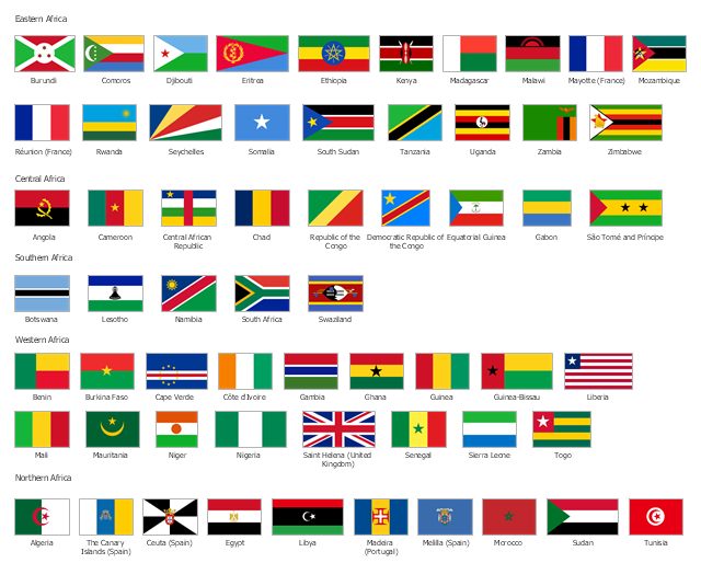
State flags of East Africa (Eastern Africa) countries and territories: Burundi, Comoros, Djibouti, Eritrea, Ethiopia, Kenya, Madagascar, Malawi, Mayotte (France), Mozambique, Réunion (France), Rwanda, Seychelles, Somalia, South Sudan, Tanzania, Uganda, Zambia, Zimbabwe.
State flags of Central Africa countries: Angola, Cameroon, Central African Republic, Chad, Republic of the Congo, Democratic Republic of the Congo, Equatorial Guinea, Gabon, São Tomé and Príncipe.
State flags of Southern Africa countries: Botswana, Lesotho, Namibia, South Africa, Swaziland.
State flags of West Africa (Western Africa) countries and territories: Benin, Burkina Faso, Cape Verde, Côte d'Ivoire, Gambia, Ghana, Guinea, Guinea-Bissau, Liberia, Mali, Mauritania, Niger, Nigeria, Saint Helena (United Kingdom), Senegal, Sierra Leone, Togo.
State flags of North Africa (Northern Africa) countries and territories: Algeria, The Canary Islands (Spain), Ceuta (Spain), Egypt, Libya, Madeira (Portugal), Melilla (Spain), Morocco, Sudan, Tunisia.
The clip art example "Design elements - Africa flags" was created using the ConceptDraw PRO diagramming and vector drawing software extended with the Continent Maps solution from the Maps area of ConceptDraw Solution Park.
Africa state flags
Geo Map - Africa

Vector design elements library Africa contains country map contours, geographical maps, cartograms and thematic maps for ConceptDraw PRO diagramming and vector drawing software. To help visualize the business and thematic information connected with geographic areas, locations or customs.
All ConceptDraw PRO documents are vector graphic files and are available for reviewing, modifying, and converting to a variety of formats: image, HTML, PDF file, MS PowerPoint Presentation, Adobe Flash, MS Visio (.VDX, .VSDX).
Geo Map - Africa - Gambia

The vector stencils library Gambia contains contours for ConceptDraw PRO diagramming and vector drawing software. This library is contained in the Continent Maps solution from Maps area of ConceptDraw Solution Park.
Geo Map - Africa - Burkina Faso

The vector stencils library Burkina Faso contains contours for ConceptDraw PRO diagramming and vector drawing software. This library is contained in the Continent Maps solution from Maps area of ConceptDraw Solution Park.
Geo Map - Africa - Mali

The vector stencils library Mali contains contours for ConceptDraw PRO diagramming and vector drawing software. This library is contained in the Continent Maps solution from Maps area of ConceptDraw Solution Park.
Geo Map - Africa - Togo

The vector stencils library Togo contains contours for ConceptDraw PRO diagramming and vector drawing software. This library is contained in the Continent Maps solution from Maps area of ConceptDraw Solution Park.
Geo Map - Africa - Nigeria

The vector stencils library Nigeria contains contours for ConceptDraw PRO diagramming and vector drawing software. This library is contained in the Continent Maps solution from Maps area of ConceptDraw Solution Park.
Geo Map - Africa - Cote d'Ivoire

Geo Map - Africa - Guinea

The vector stencils library Guinea contains contours for ConceptDraw PRO diagramming and vector drawing software. This library is contained in the Continent Maps solution from Maps area of ConceptDraw Solution Park
Geo Map - Africa - Ghana

The vector stencils library Ghana contains contours for ConceptDraw PRO diagramming and vector drawing software. This library is contained in the Continent Maps solution from Maps area of ConceptDraw Solution Park.
Geo Map - Africa - Niger

The vector stencils library Niger contains contours for ConceptDraw PRO diagramming and vector drawing software. This library is contained in the Continent Maps solution from Maps area of ConceptDraw Solution Park.
Geo Map - Africa - Benin

The vector stencils library Benin contains contours for ConceptDraw PRO diagramming and vector drawing software. This library is contained in the Continent Maps solution from Maps area of ConceptDraw Solution Park.
 Continent Maps
Continent Maps solution extends ConceptDraw PRO software with templates, samples and libraries of vector stencils for drawing the thematic maps of continents, state maps of USA and Australia.
Geo Map - Africa - Liberia

The vector stencils library Liberia contains contours for ConceptDraw PRO diagramming and vector drawing software. This library is contained in the Continent Maps solution from Maps area of ConceptDraw Solution Park.
Geo Map - Africa - Sierra Leone

The vector stencils library Sierra Leone contains contours for ConceptDraw PRO diagramming and vector drawing software. This library is contained in the Continent Maps solution from Maps area of ConceptDraw Solution Park.
- Geo Map - Africa - Nigeria | West Africa countries | Flags - Stencils ...
- Design elements - Africa flags | Design elements - African country ...
- West Africa countries | Geo Map - Africa | Geo Map - Africa - Guinea ...
- Geo Map - Africa - Liberia | Africa flags - Stencils library | African ...
- African country flags
- African Countries And Flags
- Flags Of Southern African Countries
- West Africa countries | Geo Map - Africa | Continent Maps | West ...
- Design elements - Africa flags
- African country flags - Vector stencils library | Design elements ...
- Geo Map - Africa - Congo
- North and Central America flags - Stencils library | Design elements ...
- Africa flags - Stencils library
- West Africa countries | Geo Map - Africa - Nigeria | Africa - Vector ...
- Design elements - Asian country flags | Africa flags - Stencils library ...
- Geo Map - Africa - Western Sahara | Africa - Vector stencils library ...
- Geo Map - Africa - Eritrea | Geo Map - Africa - Gabon | Africa flags ...
- European country flags - Vector stencils library | Design elements ...
- Africa flags - Stencils library
- Flag Of Continents