Geo Map - Asia - South Korea

Geo Map - Asia - Japan

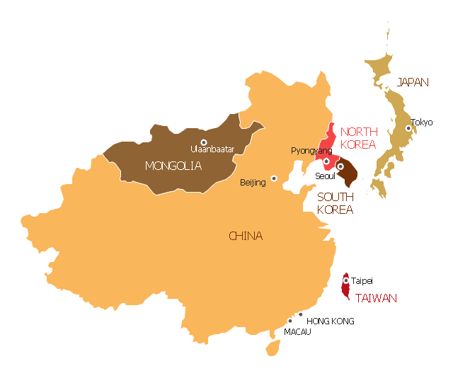
"East Asia or Eastern Asia (the latter form preferred solely by the United Nations) is a subregion of Asia that can be defined in either geographical or cultural terms. ...
The UN subregion of Eastern Asia and other common definitions of East Asia contain the entirety of the People's Republic of China, Japan, North Korea, South Korea, Mongolia and Taiwan.
Culturally, China, Japan, Korea, Taiwan, and Vietnam are commonly seen as being encompassed by cultural East Asia." [East Asia. Wikipedia]
This East Asia map was redesigned from Wikimedia Commons file: Map of East Asia.png. [commons.wikimedia.org/ wiki/ File:Map_ of_ East_ Asia.png]
This file is licensed under the Creative Commons Attribution-Share Alike 3.0 Unported license. [creativecommons.org/ licenses/ by-sa/ 3.0/ deed.en]
The example "East Asia - Political map" was created using the ConceptDraw PRO diagramming and vector drawing software extended with the Continent Maps solution from the Maps area of ConceptDraw Solution Park.
Political map - Eastern Asia
Geo Map - Asia - Vietnam

Geo Map - Asia - India

Geo Map - Asia - Philippines

Geo Map - Asia - Papua New Guinea

Geo Map - Asia - United Arab Emirates

Geo Map - Asia - Laos

The vector stencils library "Marketing maps" contains 44 state map contours with capitals and major cities: the Group of Twenty (G20) state maps, EU state maps and World map.
Use it to visualize geospatial information in your marketing infograms.
"The Group of Twenty (also known as the G-20 or G20) is a forum for the governments and central bank governors from 20 major economies. The members, shown highlighted on the map at right, include 19 individual countries—Argentina, Australia, Brazil, Canada, China, France, Germany, India, Indonesia, Italy, Japan, Republic of Korea, Mexico, Russian Federation, Saudi Arabia, South Africa, Turkey, United Kingdom, United States—and the European Union (EU). The EU is represented by the European Commission and by the ECB." [G-20 major economies. Wikipedia]
The G-20 state map contours example "Design elements - Marketing maps (G-20)" was created using the ConceptDraw PRO diagramming and vector drawing software extended with the Marketing Infographics solition from the area "Business Infographics" in ConceptDraw Solution Park.
The Group of Twenty (G-20) state maps
-state-maps-design-elements---marketing-maps-(g-20).png--diagram-flowchart-example.png)
Geo Map - Asia - Lebanon

Geo Map - Australia - New Zealand

Geo Map - Asia - Iraq

Maps of Germany With Cities

Geo Map - Europe - Bulgaria

- East Asia - Political map
- Geo Map - Asia - Japan | Asia - Vector stencils library | Greater ...
- Map East Asia
- Map Korea Png
- East Asia - Political map
- China Map Png Image
- Geo Map - Asia - Japan | Geo Map - Asia - South Korea | Geo Map ...
- Geo Map - Asia - North Korea
- Political Map East Asia
- Geo Map - Asia - Papua New Guinea | East Asia - Political map ...
- Geo Map - Asia - North Korea
- Geo Map - Asia - India | Geo Map - Asia - Japan | Geo Map - Asia ...
- South Asia - Political map
- Asia Map Logo Png
- Geo Map - Asia - South Korea
- Asia Map Png File
- Geo Map - Asia - Israel | Asian country flags - Vector stencils library ...
- Geo Map - South America - Jamaica
- Geo Map - Asia | Geo Map - Asia - India | Geo Map - Asia - Japan | A ...
- Southeast Asia - Political map | Geo Map - Asia | South Asia ...