Geo Map - Asia - Iran

World Continents Map

Geo Map — Europe

Map of Continents

Types of Map - Overview

Geo Map - Europe - Czech Republic

Geo Map — Asia

Geo Map — Europe — Germany

Geo Map - Asia - Pakistan

Geo Map - Europe - Austria

Geo Map - Asia - Kazakhstan

Geo Map - Asia - Afghanistan

Geo Map - Asia - India

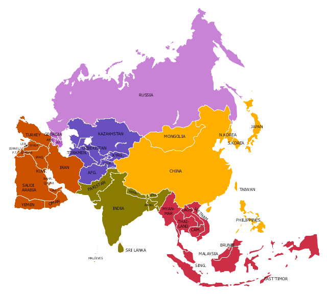
"Asia ... is the world's largest and most populous continent, located primarily in the eastern and northern hemispheres. It covers 8.7% of the Earth's total surface area and comprises 30% of its land area. With approximately 4.3 billion people, it hosts 60% of the world's current human population. Asia has a high growth rate in the modern era. For instance, during the 20th century, Asia's population nearly quadrupled." [Asia. Wikipedia]
This Asia political map was redesigned from Wikimedia Commons file: Map of Asia.svg.
[commons.wikimedia.org/ wiki/ File:Map_ of_ Asia.svg]
This file is licensed under the Creative Commons Attribution-Share Alike 3.0 Unported license. [creativecommons.org/ licenses/ by-sa/ 3.0/ deed.en]
Legend:
Purple = North Asia/ Eurasia (Russia, Georgia, Armenia, Azerbaijan),
Yellow = East Asia (China, Mongolia, Korea, Japan),
Red = South East Asia (10 ASEAN countries + East Timor),
Green = South Asia (India, Pakistan, Bangladesh, Nepal, Bhutan),
Brown = West Asia/ Middle East,
Blue = Central Asia.
The example "Political map of Asia" was created using the ConceptDraw PRO diagramming and vector drawing software extended with the Continent Maps solution from the Maps area of ConceptDraw Solution Park.
Political map - Asia
Geo Map — Europe — Spain

Geo Map — Europe — Greece

"South Asia or Southern Asia is the southern region of the Asian continent, which comprises the sub-Himalayan countries and, for some authorities, adjoining countries to the west and east. Topographically, it is dominated by the Indian Plate, which rises above sea level as northern parts of India south of the Himalayas and the Hindu Kush. South Asia is bounded on the south by the Indian Ocean and on land (clockwise, from west) by West Asia, Central Asia, East Asia, and Southeast Asia.
The current territories of Bangladesh, India, Sri Lanka and Pakistan form the core countries of South Asia, while Nepal, Bhutan and Maldives are generally included, and Afghanistan and Myanmar often added. By various deviating definitions based on often substantially different reasons, the British Indian Ocean Territory, Mauritius, Iran and the Tibet Autonomous Region are included as well. With the 7 core countries considered, South Asia is home to well over one fifth of the world's population, making it both the most populous and the most densely populated geographical region in the world. The South Asian Association for Regional Cooperation is an economic cooperation organisation in the region which was established in 1985." [South Asia. Wikipedia]
This political map sample was redesigned from the Wikimedia Commons file: South Asia (ed)update.PNG.
[commons.wikimedia.org/ wiki/ File:South_ Asia_ %28ed%29update.PNG]
The example "South Asia - Political map" was created using the ConceptDraw PRO diagramming and vector drawing software extended with the Continent Maps solution from the Maps area of ConceptDraw Solution Park.
Political map - South Asia

Geo Map — Asia — Vietnam

Geo Map — Europe — France

Geo Map - Asia - Philippines

- Continent Maps | Geo Mapping Software Examples - World Map ...
- Central Asia - Political map | Political map of Asia | Southwest Asia ...
- North Asia - Political map | Central Asia - Political map | Caucasus ...
- Country Map
- North Asia - Political map | Central Asia - Political map | Political ...
- North Asia - Political map | Geo Map - Europe - Russia | Geo Map ...
- South Asia - Political map | East Asia - Political map | Central Asia ...
- Geo Map - Asia | Central Asia - Political map | Continent Maps ...
- Continent Maps | Geo Map - Asia | Geo Map - Asia - Philippines ...
- Geo Map - Europe
- Design elements - Education maps (EU) | Geo Map - Europe ...
- East Asia - Political map | Central Asia - Political map | Southwest ...
- Geo Map - Asia - Pakistan | Types of Map - Overview | Geo Map ...
- Geo Map - Asia | South Asia - Political map | North Asia - Political ...
- Geo Map - Asia - Indonesia
- Asian Countries Maps
- Geo Map - World | Geo Map Software | Types of Map - Overview ...
- Geo Map - Asia
- Continents and Oceans Map | Continents Map | Spatial infographics ...
- South America regions - Political map | East Africa - Political map ...