This site uses cookies. By continuing to browse the ConceptDraw site you are agreeing to our Use of Site Cookies.

Map of UK — Great Britain Cities

Great Britain, also known as Britain, is an island in the North Atlantic off the north-west coast of continental Europe. With an area of 209,331 km2 (80,823 sq mi), it is the largest island in Europe and the ninth-largest in the world. How to design the Map of UK fast and easy? It is incredibly convenient to use special software. ConceptDraw PRO diagramming and vector drawing software offers the Map of UK Solution from the Maps Area of ConceptDraw Solution Park specially developed to make easier drawing the maps of UK counties, various UK related thematic maps and cartograms on their base.

Contours Map of UK

The United Kingdom of Great Britain and Northern Ireland, commonly known as the United Kingdom (UK) or Britain, is a sovereign state in Europe. How to design the Map of UK fast and easy? It is incredibly convenient to use special software. ConceptDraw PRO diagramming and vector drawing software offers the Map of UK Solution from the Maps Area of ConceptDraw Solution Park specially developed to make easier drawing the maps of UK counties, various UK related thematic maps and cartograms on their base.

United Kingdom Cities

The United Kingdom of Great Britain and Northern Ireland, commonly known as the United Kingdom (UK) or Britain, is a sovereign state in Europe. How to design the Map of UK fast and easy? It is incredibly convenient to use special software. ConceptDraw PRO diagramming and vector drawing software offers the Map of UK Solution from the Maps Area of ConceptDraw Solution Park specially developed to make easier drawing the maps of UK counties, various UK related thematic maps and cartograms on their base.

map of england, map of scotland, united kingdom map, uk map, map of uk, great britain map, map of great britain, map of united kingdom, map of wales UK Map

map of england, map of scotland, united kingdom map, uk map, map of uk, great britain map, map of great britain, map of united kingdom, map of wales
The Map of UK solution contains collection of professionally designed samples and scalable vector stencil graphics maps, representing the United Kingdom counties, regions and cities. Use the Map of UK solution from ConceptDraw Solution Park as the base fo

Map of UK — Isle of Man

The Isle of Man, also known simply as Mann, is a self-governing Crown dependency in the Irish Sea between Great Britain and Ireland. How to design the Map of UK fast and easy? It is incredibly convenient to use special software. ConceptDraw PRO diagramming and vector drawing software offers the Map of UK Solution from the Maps Area of ConceptDraw Solution Park specially developed to make easier drawing the maps of UK counties, various UK related thematic maps and cartograms on their base.
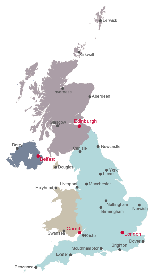
This British Isles map example shows country borders of England, Scotland, Wales and Northern Ireland, and cities of the United Kingdom.
"The United Kingdom (UK) comprises four countries: England, Scotland, Wales and Northern Ireland." [Countries of the United Kingdom. Wikipedia]
The example "British Isles map" was drawn using ConceptDraw PRO software extended with the Map of UK solution from the Maps area of ConceptDraw Solution Park.
Map of countries and cities of UK
Map of countries and  cities of UK , Yorkshire, Worcestershire, Wiltshire, Wigtownshire, Westmorland, West Lothian, Warwickshire, Tyrone, Sutherland, Sussex, Surrey, Suffolk, Stirlingshire, Staffordshire, Somerset, Shropshire, Shetland, Selkirkshire, Scotland, Rutland, Roxburghshire, Ross-shire, Renfrewshire, Radnorshire, Perthshire, Pembrokeshire, Peeblesshire, Oxfordshire, Orkney, Nottinghamshire, Nothern Ireland, Northumberland, Northamptonshire, Norfolk, Nairnshire, Moray, Montgomeryshire, Monmouthshire, Midlothian, Middlesex, Merionethshire, Londonderry, Lincolnshire, Leicestershire, Lancashire, Lanarkshire, Kirkcudbrightshire, Kinross-shire, Kincardineshire, Kent, Isle of Wight, Isle of Man, Inverness-shire, Huntingdonshire, Hertfordshire, Hampshire, Gloucestershire, Glamorgan, Flintshire, Fife, Fermanagh, Essex, England, East Lothian, Durham, Dunbartonshire, Dumfriesshire, Down, Dorset, Devon, Derbyshire, Denbighshire, Cumberland, Cromartyshire, Cornwall, Clackmannanshire, Cheshire, Carmarthenshire, Cardiganshire, Cambridgeshire, Caithness, Caernarfonshire, Buckinghamshire, British Isles, Brecknockshire, Berwickshire, Berkshire, Bedfordshire, Banffshire, Ayrshire, Armagh, Argyllshire, Antrim, Angus, Anglesey, Aberdeenshire,
Used Solutions
This map example shows UK countries borders and cities. You can also show counties borders using Action menu command.
"The United Kingdom (UK) comprises four countries: England, Scotland, Wales and Northern Ireland.
Within the United Kingdom, a unitary sovereign state, Northern Ireland, Scotland and Wales have gained a degree of autonomy through the process of devolution. The UK Parliament and British Government deal with all reserved matters for Northern Ireland and Scotland and all non-transferred matters for Wales, but not in general matters that have been devolved to the Northern Ireland Assembly, Scottish Parliament and National Assembly for Wales. Additionally, devolution in Northern Ireland is conditional on co-operation between the Northern Ireland Executive and the Government of Ireland and the British Government consults with the Government of Ireland to reach agreement on some non-devolved matters for Northern Ireland." [Countries of the United Kingdom. Wikipedia]
The example "Map of the British Isles" was drawn using ConceptDraw PRO software extended with the Map of UK solution from the Maps area of ConceptDraw Solution Park.
United Kingdom countries map
United Kingdom countries map, Yorkshire, Worcestershire, Wiltshire, Wigtownshire, Westmorland, West Lothian, Warwickshire, Tyrone, Sutherland, Sussex, Surrey, Suffolk, Stirlingshire, Staffordshire, Somerset, Shropshire, Shetland, Selkirkshire, Scotland, Rutland, Roxburghshire, Ross-shire, Renfrewshire, Radnorshire, Perthshire, Pembrokeshire, Peeblesshire, Oxfordshire, Orkney, Nottinghamshire, Nothern Ireland, Northumberland, Northamptonshire, Norfolk, Nairnshire, Moray, Montgomeryshire, Monmouthshire, Midlothian, Middlesex, Merionethshire, Londonderry, Lincolnshire, Leicestershire, Lancashire, Lanarkshire, Kirkcudbrightshire, Kinross-shire, Kincardineshire, Kent, Isle of Wight, Isle of Man, Inverness-shire, Huntingdonshire, Hertfordshire, Hampshire, Gloucestershire, Glamorgan, Flintshire, Fife, Fermanagh, Essex, England, East Lothian, Durham, Dunbartonshire, Dumfriesshire, Down, Dorset, Devon, Derbyshire, Denbighshire, Cumberland, Cromartyshire, Cornwall, Clackmannanshire, Cheshire, Carmarthenshire, Cardiganshire, Cambridgeshire, Caithness, Caernarfonshire, Buckinghamshire, British Isles, Brecknockshire, Berwickshire, Berkshire, Bedfordshire, Banffshire, Ayrshire, Armagh, Argyllshire, Antrim, Angus, Anglesey, Aberdeenshire,
Used Solutions

Map of UK — Great Britain

Great Britain, also known as Britain, is an island in the North Atlantic off the north-west coast of continental Europe. With an area of 209,331 km2 (80,823 sq mi), it is the largest island in Europe and the ninth-largest in the world. How to design the Map of UK fast and easy? It is incredibly convenient to use special software. ConceptDraw PRO diagramming and vector drawing software offers the Map of UK Solution from the Maps Area of ConceptDraw Solution Park specially developed to make easier drawing the maps of UK counties, various UK related thematic maps and cartograms on their base.

Map of UK

The United Kingdom of Great Britain and Northern Ireland, commonly known as the United Kingdom (UK) or Britain, is a sovereign state in Europe. How to design the Map of UK fast and easy? It is incredibly convenient to use special software. ConceptDraw PRO diagramming and vector drawing software offers the Map of UK Solution from the Maps Area of ConceptDraw Solution Park specially developed to make easier drawing the maps of UK counties, various UK related thematic maps and cartograms on their base.