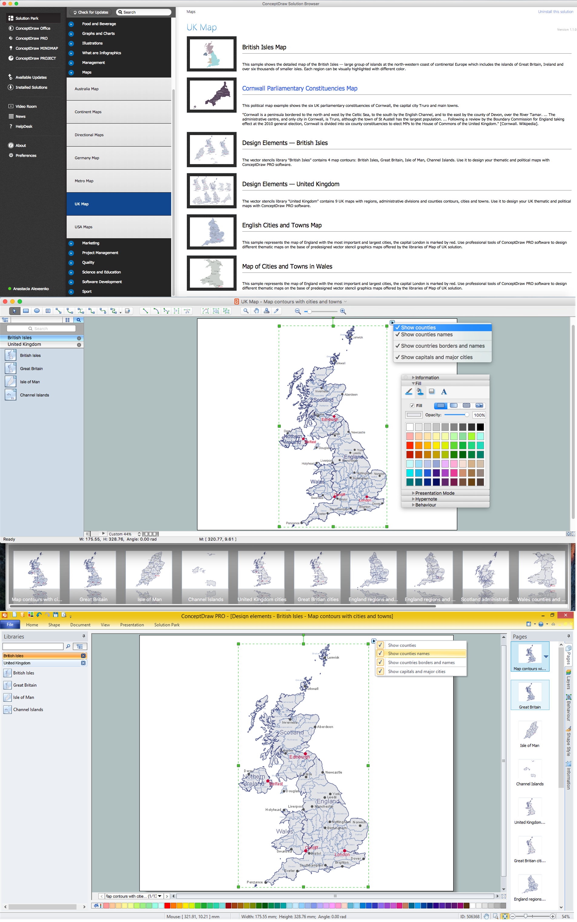
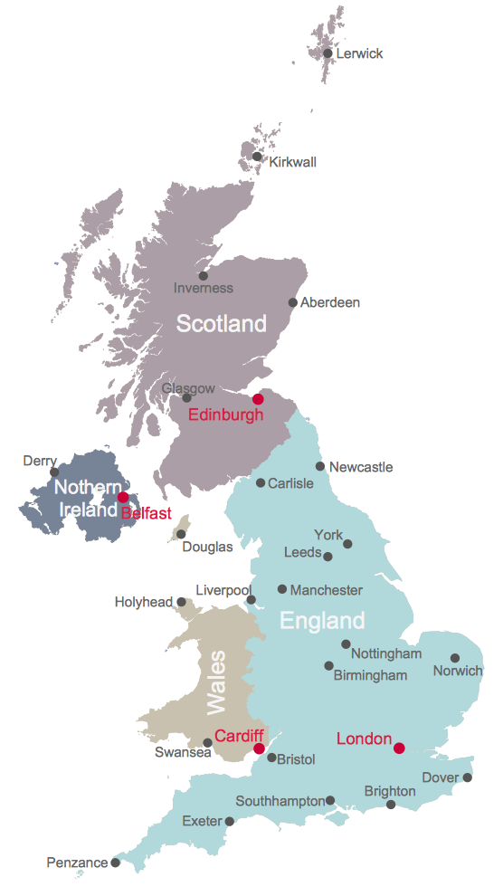
Contours Map of UK
“The United Kingdom of Great Britain and Northern Ireland, commonly known as the United Kingdom (UK) or Britain, is a sovereign state in Europe. Lying off the north-western coast of the European mainland, it includes the island of Great Britain—a term also applied loosely to refer to the whole country—the north-eastern part of the island of Ireland and many smaller islands. Northern Ireland is the only part of the UK that shares a land border with another state—the Republic of Ireland. Apart from this land border, the UK is surrounded by the Atlantic Ocean, with the North Sea to its east, the English Channel to its south and the Celtic Sea to its south-southwest. The Irish Sea lies between Great Britain and Ireland. With an area of 93,800 square miles (243,000 km2), the UK is the 80th-largest sovereign state in the world and the 11th-largest in Europe. It is also is the 22nd-most populous country, with an estimated 64.5 million inhabitants.”
[from Wikipedia]
Counties
- Aberdeenshire
- Anglesey
- Angus
- Antrim
- Argyllshire
- Armagh
- Ayrshire
- Banffshire
- Beds
- Berkshire
- Berwickshire
- Breconshire
- Buckinghamshire
- Buteshire
- Caernarfonshire
- Caithness
- Cambs
- Cardiganshire
- Carmarthenshire
- Cheshire
- Clacks
- Cornwall
- Cromartyshire
- Cumberland
- Denbighshire
- Derbyshire
- Devon
- Dorset
- Down
- Dumfriesshire
- Dunbartonshire
- Durham
- East Lothian
- Essex
- Fermanagh
- Fife
- Flintshire
- Glamorgan
- Glos
- Hampshire
- Herefs
- Herts
- Hunts
- Inverness-shire
- Isle of Man
- Isle of Wight
- Kent
- Kincardineshire
- Kinross-shire
- Kirkcudbrightshire
- Lanarkshire
- Lancashire
- Leics
- Lincolnshire
- Londonderry
- Merionethshire
- Middx
- Midlothian
- Monmouthshire
- Montgomeryshire
- Moray
- Nairnshire
- Norfolk
- Northants
- Northumberland
- Notts
- Orkney
- Oxon
- Peeblesshire
- Pembrokeshire
- Perthshire
- Radnorshire
- Ross-shire
- Roxburghshire
- Rutland
- Selkirkshire
- Shetland
- Shropshire
- Somerset
- Staffordshire
- Stirlingshire
- Suffolk
- Surrey
- Sussex
- Sutherland
- Tyrone
- Warwickshire
- West Lothian
- Westmorland
- Wigtownshire
- Wiltshire
- Worcs
- Yorkshire
Cities
- Aberdeen
- Belfast
- Birmingham
- Brighton
- Bristol
- Cardiff
- Carlisle
- Derry
- Douglas
- Dover
- Edinburgh
- Exeter
- Glasgow
- Holyhead
- Inverness
- Kirkwall
- Leeds
- Lerwick
- Liverpool
- London
- Manchester
- Newcastle
- Norwich
- Nottingham
- Penzance
- Southhampton
- Swansea
- York
How to design the Map of UK fast and easy? It is incredibly convenient to use special software. ConceptDraw DIAGRAM diagramming and vector drawing software offers the Map of UK Solution from the Maps Area of ConceptDraw Solution Park specially developed to make easier drawing the maps of UK counties, various UK related thematic maps and cartograms on their base.
Example 1. UK Map Solution — Contours Map of UK
Map of UK Solution provides wide collection of predesigned maps of UK countries, islands and counties, and 2 libraries with 12 ready-to-use vector maps objects which lie at the base of included samples.

Example 2. British Isles Library Design Elements

Example 3. United Kingdom Library Design Elements
Thanks to all these tools, now design of UK Map and thematic maps for the countries included to UK is very simple process. All that you need is follow the next steps:
- create new ConceptDraw document,
- drag the needed objects from the libraries of Map of UK Solution,
- make changes in color style and apply the commands from the object's action menu to make your map colorful and successful.

Example 4. Map of UK — British Isles Counties
The maps, geospatial infographics and especially thematic maps which are the popular visual way of studying different points of interest and geographical data, all they are incredibly useful in various scientific fields. Design them easy in ConceptDraw DIAGRAM
Use the Map of UK solution for ConceptDraw DIAGRAM software to design your own Map of UK quick, easy and effective, and then successfully use it in your life or work activity.
All source documents are vector graphic documents. They are available for reviewing, modifying, or converting to a variety of formats (PDF file, MS PowerPoint, MS Visio, and many other graphic formats) from the ConceptDraw STORE. The Map of UK Solution is available for all ConceptDraw DIAGRAM users.
THREE RELATED HOW TO's:
England is a country that is part of the United Kingdom. It shares land borders with Scotland to the north and Wales to the west.
Design of various maps, including the Map of England is usually complex and labor-intensive process. But now we have a possibility to create UK maps fast and easy thanks to the ConceptDraw DIAGRAM diagramming and vector drawing software enhanced with Map of UK Solution from the Maps Area of ConceptDraw Solution Park.
Picture: Map of England
Related Solution:
The United Kingdom which includes England, Scotland, Wales, and Northern Ireland, is the 22nd-most populous country - important global city and financial centre. For administrative and political purposes, each country is divided into a number of counties, which are then subdivided into districts.
ConceptDraw DIAGRAM diagramming and vector drawing software offers the Map of UK Solution from the Maps Area of ConceptDraw Solution Park with large collection of predesigned samples and libraries with vector map objects for easy drawing the United Kingdom Map of any degree of detail.
Picture: United Kingdom Map
Related Solution:
You want create a professional room plan quick and easy? ConceptDraw DIAGRAM diagramming and vector drawing software will help you. It’s very simple and convenient design the room plans with Floor Plans Solution from the Building Plans area of ConceptDraw Solution Park.
Picture: Room Planning Software
Related Solution: