Map of Australia depicting time zones offsets from UTC by state (including daylight saving).
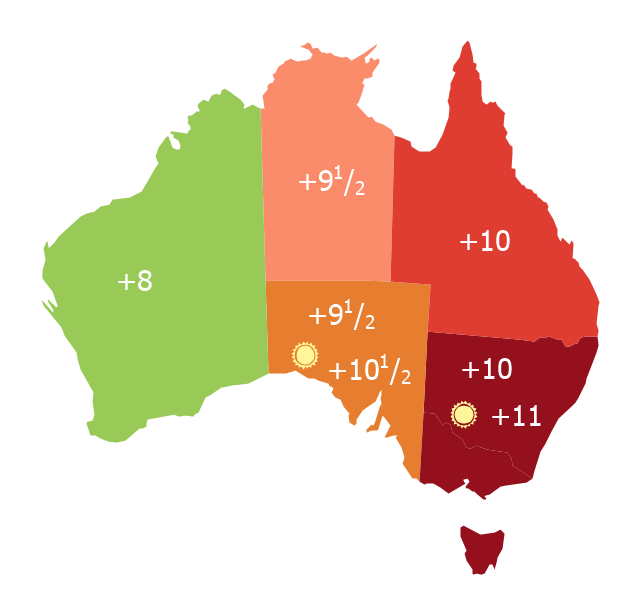
"Time in Australia uses more than three time zones, including Australian Western Standard Time (AWST; UTC+08:00), Australian Central Standard Time (ACST; UTC+09:30), and Australian Eastern Standard Time (AEST; UTC+10:00). Time is regulated by the individual state governments, some of which observe daylight saving time (DST). Australia's external territories observe different time zones." [Time in Australia. Wikipedia]
This thematic map was redesigned from Wikipedia file: Australia states timezones.png. [commons.wikimedia.org/ wiki/ File:Australia-states-timezones.png]
This file is licensed under the Creative Commons Attribution-Share Alike 3.0 Unported license.
[creativecommons.org/ licenses/ by-sa/ 3.0/ deed.en]
The thematic map example "Australia states time zones" was created using the ConceptDraw PRO diagramming and vector drawing software extended with the Continent Maps solution from the Maps area of ConceptDraw Solution Park.
Thematic map - Australia states time zones
7 Continents Map

 Continent Maps
Continent Maps solution extends ConceptDraw PRO software with templates, samples and libraries of vector stencils for drawing the thematic maps of continents, state maps of USA and Australia.
 Germany Map
The Germany Map solution contains collection of samples, templates and scalable vector stencil graphic maps, representing map of Germany and all 16 states of Germany. Use the Germany Map solution from ConceptDraw Solution Park as the base for various them
 Spatial Dashboard
Spatial dashboard solution extends ConceptDraw PRO software with templates, samples and vector stencils libraries with thematic maps for drawing visual dashboards showing spatial data.
 USA Maps
Use the USA Maps solution to create a map of USA, a US interstate map, printable US maps, US maps with cities and US maps with capitals. Create a complete USA states map.
- Choropleth Map Australia Population
- USA Maps | Continent Maps | 7 Continents Map | Choropleth Map Of ...
- Map Australia
- How to Draw Maps of Australia Using ConceptDraw PRO | Australia ...
- Australia states time zones - Thematic map | Design elements ...
- Australia Map Example
- Australia states time zones - Thematic map | 7 Continents Map ...
- Spatial Dashboard | Europe spatial dashboard - Template | What is ...
- Visualization Spatial Data Using Thematic Maps Combined with ...
- Pyramid Diagram | How to Operate with Project Time Frames in ...
- Project task status dashboard - Template | Sales Dashboard ...