Geo Map - Asia - Papua New Guinea

Geo Map - Asia - Indonesia

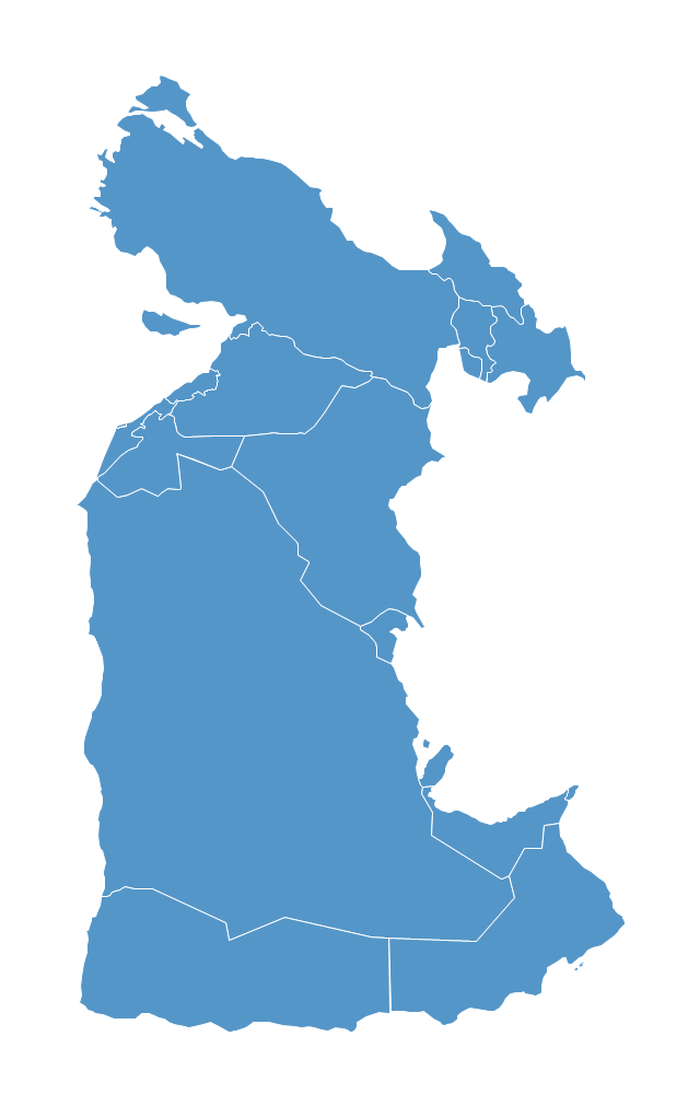
Southwest Asia region comprises countries: Turkey, Georgia, Azerbaijan, Armenia, Syria, Lebanon, Israel, Jordan, Iraq, Kuwait, Cyprus, Saudi Arabia, Bahrain, United Arab Emirates, Oman, Qatar, Yemen.
This political map sample was redesigned from the Wikimedia Commons file: Southwest-Asia-map.PNG.
[commons.wikimedia.org/ wiki/ File:Southwest-Asia-map.PNG]
The example "Southwest Asia - Political map" was created using the ConceptDraw PRO diagramming and vector drawing software extended with the Continent Maps solution from the Maps area of ConceptDraw Solution Park.
Political map - Southwest Asia
"South Asia or Southern Asia is the southern region of the Asian continent, which comprises the sub-Himalayan countries and, for some authorities, adjoining countries to the west and east. Topographically, it is dominated by the Indian Plate, which rises above sea level as northern parts of India south of the Himalayas and the Hindu Kush. South Asia is bounded on the south by the Indian Ocean and on land (clockwise, from west) by West Asia, Central Asia, East Asia, and Southeast Asia.
The current territories of Bangladesh, India, Sri Lanka and Pakistan form the core countries of South Asia, while Nepal, Bhutan and Maldives are generally included, and Afghanistan and Myanmar often added. By various deviating definitions based on often substantially different reasons, the British Indian Ocean Territory, Mauritius, Iran and the Tibet Autonomous Region are included as well. With the 7 core countries considered, South Asia is home to well over one fifth of the world's population, making it both the most populous and the most densely populated geographical region in the world. The South Asian Association for Regional Cooperation is an economic cooperation organisation in the region which was established in 1985." [South Asia. Wikipedia]
This political map sample was redesigned from the Wikimedia Commons file: South Asia (ed)update.PNG.
[commons.wikimedia.org/ wiki/ File:South_ Asia_ %28ed%29update.PNG]
The example "South Asia - Political map" was created using the ConceptDraw PRO diagramming and vector drawing software extended with the Continent Maps solution from the Maps area of ConceptDraw Solution Park.
Political map - South Asia

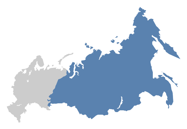
"North Asia or Northern Asia is a subregion of Asia, consisting of the Asian portion of Russia – area on the east of Ural Mountains." [North Asia. Wikipedia]
This political map sample was redesigned from the Wikimedia Commons file: Location-Asia-UNsubregions.png. [commons.wikimedia.org/ wiki/ File:Location-Asia-UNsubregions.png]
The example "North Asia - Political map" was created using the ConceptDraw PRO diagramming and vector drawing software extended with the Continent Maps solution from the Maps area of ConceptDraw Solution Park.
Political map - North Asia
Geo Map - Europe - Bulgaria

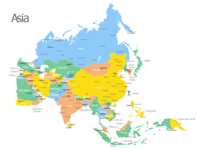
Use this template of Asia map with contours of Asian countries, capitals and main cities to design your political or thematic map.
This Asia map template for the ConceptDraw PRO diagramming and vector drawing software is included in the Continent Maps solution from the Maps area of ConceptDraw Solution Park.
This Asia map template for the ConceptDraw PRO diagramming and vector drawing software is included in the Continent Maps solution from the Maps area of ConceptDraw Solution Park.
Asia map
Geo Map - Asia - Kyrgyzstan

Geo Map - Asia - Iraq

Geo Map - Asia

Geo Map - Asia - Japan

Geo Map - Asia - United Arab Emirates

Geo Map - Asia - Tajikistan

Geo Map - Asia - Bhutan

How To Do A Mind Map In PowerPoint

- Geo Map - Asia - Papua New Guinea | South Asia - Political map ...
- North Asia - Political map | Geo Map - Asia - Papua New Guinea ...
- Geo Map - Asia - Papua New Guinea | Geo Map - Asia - South ...
- Asia map with capitals - Template | Geo Map - Asia - Indonesia ...
- South Asia - Political map | Geo Map - Asia - Papua New Guinea ...
- Geo Map - Asia - Papua New Guinea | Southwest Asia - Political ...
- Southeast Asia Map Png Hd
- Geo Map - Asia - Papua New Guinea | How To Do A Mind Map In ...
- Geo Map - Asia - Papua New Guinea
- Geo Map - Asia - Papua New Guinea | Geo Map - Asia - Indonesia ...
- Southwest Asia Map Png Political
- Geo Map - Asia - Papua New Guinea | Geo Map - Asia - Iran | Middle ...
- Geo Map - Asia - Papua New Guinea
- Saudi Map Outline Png
- Indian Map Vector Png
- Geo Map - Asia - Papua New Guinea | Geo Map - Oceania | Geo ...
- Geo Map - Australia | Geo Map - Asia - Papua New Guinea | Geo ...
- How To Do A Mind Map In PowerPoint | South Asia - Political map ...
- Asian Map Drawing Wiki How